
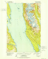
1951 Map of Juneau D-4
USGS Topo · Published 1952About this map
The gold mining legacy of Southeast Alaska is etched into the steep slopes of the Tongass National Forest along the eastern shore of Lynn Canal. This early 1950s survey documents a cluster of dormant industrial sites, including the Ivanhoe Mine, Horrible Mine, and Kensington Mine. An Aerial Tram once linked these highland operations to the coast near Comet, where the Comet Mines and Sherman settlement sat at the base of the mountains.
Find a feature on this map
36 named features on this map. Tap any name to fly to it.
Don’t see what you’re looking for? This feature index may not catch every label — zoom into the map to look around manually.
Map Details
Editions of this 1951 Juneau D-4 Map
2 editions found
Other maps of this area

1948 · Juneau C-5
USGS Topo · 1:63,360

1948 · Juneau C-4
USGS Topo · 1:63,360

1948 · Juneau D-3
USGS Topo · 1:63,360

1948 · Skagway A-1
USGS Topo · 1:63,360

1949 · Atlin
USGS Topo · 1:250,000

1949 · Juneau D-5
USGS Topo · 1:63,360

1949 · Juneau D-4
USGS Topo · 1:63,360

1949 · Juneau C-4
USGS Topo · 1:63,360

1949 · Juneau D-3
USGS Topo · 1:63,360

1951 · Juneau
USGS Topo · 1:250,000