1940s Maps of Kenai Peninsula, Alaska
Explore 11 historic maps of Kenai Peninsula from the 1940s. These maps offer a rare glimpse into what life looked like during the 1940s — showing old roads, neighborhoods, homes, and landmarks that have changed or disappeared over time.
Whether you're researching your family's past, planning a metal detecting trip, or studying how Kenai Peninsula's landscape evolved across the 1940s, these high-resolution maps are a powerful tool for exploring the history of this region.
- Focus on a specific era: All maps on this page are from the 1940s, giving you a focused view of this time period.
- See what’s changed: Compare century-old streets, trails, and buildings to today's modern landscape using overlays and satellite layers.
- Research with precision: Use these maps for genealogy, historical research, land use analysis, or educational projects.
- View, download, or print: Maps are fully viewable online in high resolution, and can be downloaded or printed for your own records.
Start exploring Kenai Peninsula's history through authentic maps from the 1940s. This is your window into the past.
Kenai Peninsula, AK maps
(11)- 1944 Map of Kenai, 1954 Print
 1944 Kenai1954 Print · USGSThe Kenai Peninsula and Cook Inlet are captured here during a period of postwar growth, just as the regional road system began to expand. Genealogists and historians can trace early settlements and family landmarks such as Salamatoff, Stelters Ranch, and the Snug Harbor Cannery.4 unique versions available
 - 1946 Map of Blying Sound, 1954 Print
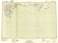 1946 Blying Sound1954 Print · USGSThe Kenai Peninsula coastline at the end of World War II reveals a wilderness of massive ice fields and deep fjords. Trace the glacial reaches of the Harding Ice Field and locate coastal landmarks like Caines Head and Cape Resurrection.2 unique versions available
 - 1946 Map of Lake Clark, 1954 Print
 1946 Lake Clark1954 Print · USGSInterior Alaska during the mid-forties and early fifties reveals a remote landscape of glacial lakes and mountain peaks. You can trace early settlements at Nondalton, find the Old Village trail network, and locate the Tanalian Point Landing Field near the shores of Lake Clark.2 unique versions available
 - 1946 Map of Seldovia C-5, 1958 Print
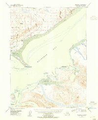
 1946 Seldovia C-51958 Print · USGSThe coastal settlement of Homer and the lower Kenai Peninsula are captured here just after the war as the regional road network began to solidify. Researchers can trace early infrastructure like the Sterling Highway, a shoreline Coal Mine, and the Seaplane Anchorage.
 - 1946 Map of Seldovia D-5, 1958 Print
 1946 Seldovia D-51958 Print · USGSThe Kenai Peninsula coastline comes into focus just after the war as the modern road network begins to take shape. Researchers can trace the early layout of Anchor Point and identify coastal landmarks like Cape Starichkof and the Sterling Highway.
 - 1948 Map of Mt Katmai, 1954 Print
 1948 Mt Katmai1954 Print · USGSKatmai National Monument appears in the late 1940s as a landscape of dramatic volcanic activity and displaced settlements. Researchers can trace the geological impact of the 1912 eruption via the Valley of Ten Thousand Smokes or locate early habitation sites like Savonoski (Abandoned).
 - 1948 Map of Seldovia C-4, 1955 Print
 1948 Seldovia C-41955 Print · USGSThe Kachemak Bay coastline comes alive in the mid-1940s, showing the early infrastructure of the Homer area before its modern expansion. Genealogists and researchers can locate old landmarks like Millers Landing, the original Homer Airport, and the Sawmill along the waterfront.2 unique versions available
 - 1949 Map of Iliamna C-1
 1949 Iliamna C-11949 Print · USGSThe remote coast of the Kenai Peninsula is documented here in the late 1940s, showing a wild landscape of jagged peaks and deep bays. Researchers can trace the maritime features of Cook Inlet and find landmarks like Mt Pomeroy and Oil Point.
 - 1949 Map of Seldovia C-4
 1949 Seldovia C-41949 Print · USGSKachemak Bay and the Kenai Peninsula shoreline are captured here in the late 1940s, showing early maritime and aviation development. Trace the origins of local industry and navigation at Millers Landing, the Homer Spit, and the Homer Airport.
 - 1949 Map of Tyonek, 1954 Print
 1949 Tyonek1954 Print · USGSUpper Cook Inlet and the Alaska Range appear here in the mid-twentieth century as a landscape of massive glaciers and river-bound outposts. Researchers can trace the early rail corridor through Willow, locate the Moquawkie Indian Reservation, and find the site of McDougall.2 unique versions available
 - 1949 Map of Seldovia D-4, 1958 Print
 1949 Seldovia D-41958 Print · USGSThe interior of the Kenai Peninsula comes into focus during the late 1940s, showing a rugged landscape of unnamed drainages and high peaks. Researchers can trace the complex courses of Deep Creek and the Anchor River, or locate landmarks like Ninilchik Dome and Bald Mtn.
End of results
Showing maps 1-11 of 11
Top cities of Kenai Peninsula
- Kenai historical maps
- Homer historical maps
- Soldotna historical maps
- Seward historical maps
- Kachemak City historical maps
- Nikolaevsk historical maps
See more
Frequently asked questions
- What are the different types of historical maps available for Kenai Peninsula?
- What is the oldest map of Kenai Peninsula?
- Where can I purchase historical maps of Kenai Peninsula for my home or office?
- Where can I download high-res historical maps of Kenai Peninsula?
- Are there historical topographic maps available for Kenai Peninsula?
- Is there historical aerial imagery available for Kenai Peninsula?
- Where are historical maps of Kenai Peninsula sourced from?