1950s Maps of Kenai Peninsula, Alaska
Explore 203 historic maps of Kenai Peninsula from the 1950s. These maps offer a rare glimpse into what life looked like during the 1950s — showing old roads, neighborhoods, homes, and landmarks that have changed or disappeared over time.
Whether you're researching your family's past, planning a metal detecting trip, or studying how Kenai Peninsula's landscape evolved across the 1950s, these high-resolution maps are a powerful tool for exploring the history of this region.
- Focus on a specific era: All maps on this page are from the 1950s, giving you a focused view of this time period.
- See what’s changed: Compare century-old streets, trails, and buildings to today's modern landscape using overlays and satellite layers.
- Research with precision: Use these maps for genealogy, historical research, land use analysis, or educational projects.
- View, download, or print: Maps are fully viewable online in high resolution, and can be downloaded or printed for your own records.
Start exploring Kenai Peninsula's history through authentic maps from the 1950s. This is your window into the past.
Kenai Peninsula, AK maps
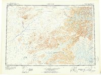
(203)- 1950 Map of Kenai
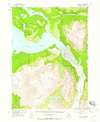
 1950 Kenai1950 Print · USGSThe Kenai Peninsula and Cook Inlet appear here during a pivotal era of mid-century growth and road construction. Researchers can trace the early layout of Soldotna, locate the Snug Harbor Cannery, and see the footprint of Salamatof.2 unique versions available
 - 1950 Map of Kenai C-3, 1959 Print
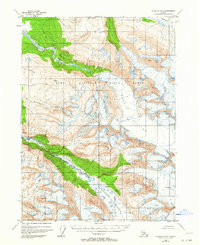
 1950 Kenai C-31959 Print · USGSThe Kenai Peninsula in the early fifties shows a burgeoning wilderness frontier at the dawn of modern settlement. Trace the early layout of Sterling and the Sterling Highway alongside remote landmarks like Mackeys Lakes and the Kenai River.
 - 1950 Map of Kenai B-1, 1960 Print
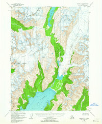
 1950 Kenai B-11960 Print · USGSThe Kenai Peninsula wilderness is captured here in the early 1950s, showing the intersection of new roads and ancient ice. Trace early travel routes like the Sterling Highway and Seven Lakes Trail or locate remote outposts like Statters Ranch.4 unique versions available
 - 1950 Map of Seldovia D-2, 1964 Print
 1950 Seldovia D-21964 Print · USGSThe Kenai Peninsula wilderness is captured here in the mid-twentieth century, showing a landscape defined by massive ice fields and protected habitats. Map collectors can trace the icy expanses of Chernof Glacier and the headwaters of the Fox River.2 unique versions available
 - 1950 Map of Seward A-6, 1964 Print
 1950 Seward A-61964 Print · USGSThe Kenai Peninsula coastline is captured here in the mid-twentieth century, showing a landscape defined by massive ice fields and deep fjords. You can trace the reach of the Godwin Glacier and the Ellsworth Glacier as they carve toward Day Harbor.2 unique versions available
 - 1950 Map of Seward A-8, 1964 Print
 1950 Seward A-81964 Print · USGSThe frozen interior of the Kenai Peninsula is captured here in the early 1950s, centered on the massive Harding Icefield. Researchers can study the mid-century extent of the Bear Glacier and Lowell Glacier before decades of change, or trace the remote drainages of Placer Creek and Martin Cr.
 - 1950 Map of Blying Sound D-7, 1964 Print
 1950 Blying Sound D-71964 Print · USGSCoastal Alaska at the mid-century reveals a landscape of ice and deep water south of Seward. Boaters and historians can trace the intricate shorelines of Resurrection Bay and locate landmarks like Caines Head and Rugged Island.
 - 1950 Map of Kenai B-3, 1966 Print
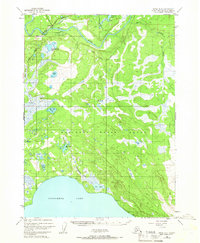 1950 Kenai B-31966 Print · USGSThe Kenai Peninsula at the start of the 1950s shows the early growth of Soldotna as the regional road network began to take shape. Researchers can trace the original path of the Sterling Highway and locate remote Cabins along the banks of the Kenai River.2 unique versions available
 - 1950 Map of Blying Sound D-6, 1967 Print
 1950 Blying Sound D-61967 Print · USGSThe Kenai Peninsula coastline at mid-century reveals a landscape of remote maritime inlets and steep coastal headlands. Researchers can trace the rugged contours of Day Harbor, the sheltered Safety Cove, and landmarks like Cape Fairfield.3 unique versions available
 - 1950 Map of Kenai D-4, 1976 Print
 1950 Kenai D-41976 Print · USGSThe northern Kenai Peninsula and Cook Inlet appear here during the mid-century expansion of Alaska's oil industry. Researchers can locate early offshore installations like Oil Platform Anna and trace the original North Kenai Road as it skirts the Kenai National Moose Range.2 unique versions available
 - 1950 Map of Seward A-7, 1976 Print
 1950 Seward A-71976 Print · USGSSeward and its surrounding fjord-like landscape are captured here at mid-century, just as the port town solidified its role as a rail and maritime hub. Researchers can trace the original rail alignment of the Alaska Railroad, locate the Army Dock, and find early landmarks like Bayview School and the Sawmill.3 unique versions available
 - 1950 Map of Blying Sound D-5, 1988 Print
 1950 Blying Sound D-51988 Print · USGSThe Kenai Peninsula coastline at mid-century reveals a wild and roadless landscape shaped by glacial ice and the open sea. Map collectors and researchers can trace the reach of Excelsior Glacier and locate maritime landmarks like Cape Fairfield and Pinnacle Rock.
 - 1951 Map of Blying Sound
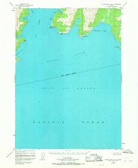
 1951 Blying Sound1951 Print · USGSThe Kenai Peninsula coastline in the early fifties shows a landscape of tidewater glaciers and remote islands before the 1964 earthquake. Trace coastal features like the Harding Ice Field, Montague Island, and the maritime passage of Harding Gateway.2 unique versions available
 - 1951 Map of Seldovia C-5
 1951 Seldovia C-51951 Print · USGSThe Kenai Peninsula shoreline comes to life in the early fifties as the southern road system reached toward the sea. Trace the early layout of Homer, the coastal Coal Mine, and landmarks like Ohlson Mtn and Diamond Gulch.
 - 1951 Map of Lake Clark
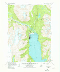
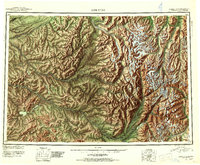
 1951 Lake Clark1951 Print · USGSThe Lake Clark region of the Alaskan interior was a remote frontier in the early 1950s, defined by high peaks and sprawling river systems. Researchers can trace historic travel routes like the Native Trail and locate isolated settlements at Old Village or Nondalton.2 unique versions available
 - 1951 Map of Seldovia D-5
 1951 Seldovia D-51951 Print · USGSThe Kenai Peninsula coastline during the early fifties shows a burgeoning frontier landscape connected by the new Sterling Highway. Researchers can trace the layout of Anchor Point, the local Airstrip, and several major salmon streams like Deep Creek and the Stariski River.
 - 1951 Map of Seldovia D-4
 1951 Seldovia D-41951 Print · USGSThe Kenai Peninsula uplands are shown in the early fifties, featuring a complex network of glacial-fed streams and high ridges. Researchers can trace the rugged headwaters of the Anchor River, the steep slopes of Ninilchik Dome, and the shoreline of Kachemak Bay.
 - 1951 Map of Seward
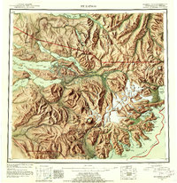
 1951 Seward1951 Print · USGSThe Kenai Peninsula and Prince William Sound come to life in the early 1950s as the rail and maritime networks linked remote coastal outposts. Genealogists and historians can trace the Alaska Railroad corridor through Seward, find the Jesse Lee Indian School, and locate isolated camps like Latouche and Chenega.4 unique versions available
 - 1951 Map of Anchorage
 1951 Anchorage1951 Print · USGSMid-century Anchorage and the Matanuska Valley are seen here during a period of rapid strategic growth. Trace the development of Fort Richardson, early rail stops at Wasilla, and established mining operations like the Independence Mine or Premier Mine.4 unique versions available
 - 1951 Map of Tyonek
 1951 Tyonek1951 Print · USGSThe Cook Inlet and the Alaska Range come into focus in the early fifties as the region's rail and trail networks evolved. Trace the path of the Alaska Railroad through Willow or locate the historic Iditarod Trail near Susitna.
 - 1951 Map of Lime Hills, 1952 Print
 1951 Lime Hills1952 Print · USGSAlaska's interior wilderness appears at mid-century as a complex network of glacial rivers and peaks long before modern infrastructure. Trace the early routes of bush pilots and trappers through Sled Pass or find the lone Cabin near Two Lakes.4 unique versions available
 - 1951 Map of Mt Katmai, 1952 Print
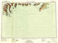
 1951 Mt Katmai1952 Print · USGSThe Alaska Peninsula at mid-century reveals a landscape of volcanic upheaval and empty settlements following the Great Eruption. Researchers can trace the vanished communities of Savonoski and Katmai Village or locate the Novarupta Volcano.11 unique versions available
 - 1951 Map of Seldovia, 1952 Print
 1951 Seldovia1952 Print · USGSThe lower Kenai Peninsula appears here in the early fifties as a network of coastal outposts and maritime landing sites. Researchers can trace early settlements like Seldovia, locate family-named points such as Millers Landing, and explore the limits of the Kenai National Moose Range.8 unique versions available
 - 1951 Map of Seward A-6, 1954 Print
 1951 Seward A-61954 Print · USGSThe Kenai Peninsula coastline is defined by massive ice fields and deep fjords in the early 1950s. Trace the dramatic glacial movements of Godwin Glacier and maritime landmarks like Resurrection Harbor and Bowen Anchorage.2 unique versions available
 - 1951 Map of Seward A-7, 1954 Print
 1951 Seward A-71954 Print · USGSSeward and its surrounding mountain peaks are shown here in the early fifties at the terminus of the rail line. Genealogists and historians can trace the Alaska Railroad yard, the Bayview School, and the busy waterfront at Army Dock.4 unique versions available
Showing maps 1-25 of 203
Top cities of Kenai Peninsula
- Kenai historical maps
- Homer historical maps
- Soldotna historical maps
- Seward historical maps
- Kachemak City historical maps
- Nikolaevsk historical maps
See more
Frequently asked questions
- What are the different types of historical maps available for Kenai Peninsula?
- What is the oldest map of Kenai Peninsula?
- Where can I purchase historical maps of Kenai Peninsula for my home or office?
- Where can I download high-res historical maps of Kenai Peninsula?
- Are there historical topographic maps available for Kenai Peninsula?
- Is there historical aerial imagery available for Kenai Peninsula?
- Where are historical maps of Kenai Peninsula sourced from?