1960s Maps of Kenai Peninsula, Alaska
Explore 8 historic maps of Kenai Peninsula from the 1960s. These maps offer a rare glimpse into what life looked like during the 1960s — showing old roads, neighborhoods, homes, and landmarks that have changed or disappeared over time.
Whether you're researching your family's past, planning a metal detecting trip, or studying how Kenai Peninsula's landscape evolved across the 1960s, these high-resolution maps are a powerful tool for exploring the history of this region.
- Focus on a specific era: All maps on this page are from the 1960s, giving you a focused view of this time period.
- See what’s changed: Compare century-old streets, trails, and buildings to today's modern landscape using overlays and satellite layers.
- Research with precision: Use these maps for genealogy, historical research, land use analysis, or educational projects.
- View, download, or print: Maps are fully viewable online in high resolution, and can be downloaded or printed for your own records.
Start exploring Kenai Peninsula's history through authentic maps from the 1960s. This is your window into the past.
Kenai Peninsula, AK maps
(8)- 1961 Map of Seldovia C-5, 1962 Print
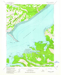
 1961 Seldovia C-51962 Print · USGSThe Kenai Peninsula shoreline and the burgeoning community of Homer are detailed in the early 1960s. Genealogists and historians can trace early neighborhood roads like Skyline Drive and find local landmarks including Lofgren and the Anchor River Campground.4 unique versions available
 - 1961 Map of Seldovia C-4, 1962 Print
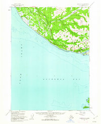
 1961 Seldovia C-41962 Print · USGSThe Kenai Peninsula shoreline and the waters of Kachemak Bay come into sharp focus in the early sixties. You can trace the development of Homer and the Homer Spit, or locate isolated landmarks like the Lighthouse near Halibut Cove.3 unique versions available
 - 1961 Map of Seldovia D-4, 1962 Print
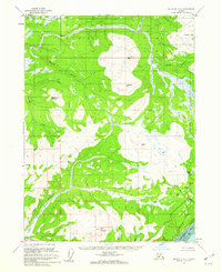 1961 Seldovia D-41962 Print · USGSThe southern Kenai Peninsula interior is shown here in the early sixties, a time of remote wilderness and early trail blazing. Researchers can trace the winding Anchor River and locate isolated landmarks like Ninilchik Dome, Bald Mountain, and the Tractor Trail.3 unique versions available
 - 1961 Map of Seldovia D-5, 1962 Print
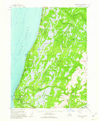 1961 Seldovia D-51962 Print · USGSThe Kenai Peninsula coastline comes into focus in the early sixties as new roads and settlements began to define the region. You can trace early coastal developments like Whiskey Gulch, the Airstrip at Anchor Point, and the path of the Sterling Highway.2 unique versions available
 - 1962 Map of Anchorage, 1966 Print
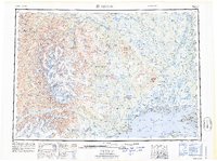
 1962 Anchorage1966 Print · USGSThe Anchorage bowl and Matanuska Valley appear in this mid-century survey during a period of significant military and industrial expansion. Researchers can trace the Alaska Railroad through Sutton and Jonesville or locate historic stops like Meekins Roadhouse and the Watertower Inn.6 unique versions available
 - 1963 Map of Seldovia, 1967 Print
 1963 Seldovia1967 Print · USGSThe lower Kenai Peninsula in the 1960s reveals a rugged coastal frontier where the highway finally meets the sea at Homer. Researchers can trace old settlements and family sites at Happy Valley, Stariski, and the Indian Village near Seldovia.5 unique versions available
 - 1964 Map of Mt. Katmai
 1964 Mt. Katmai1964 Print · USGSThe Katmai region in the mid-sixties reveals a landscape shaped by volcanic upheaval and remote wilderness outposts. Researchers can trace the volcanic scars of the Valley of Ten Thousand Smokes or locate remote sites like Katmai Village and Kulik Lodge.
 - 1965 Map of Tyonek
 1965 Tyonek1965 Print · USGSUpper Cook Inlet in the mid-sixties reveals a landscape defined by massive glaciers and the early footprints of coastal settlements. Trace the rail-and-river network from The Alaska Railroad to isolated outposts like Old Tyonek, Ladd, and the Moquawkie (Tyonek) Indian Reservation.
End of results
Showing maps 1-8 of 8
Top cities of Kenai Peninsula
- Kenai historical maps
- Homer historical maps
- Soldotna historical maps
- Seward historical maps
- Kachemak City historical maps
- Nikolaevsk historical maps
See more
Frequently asked questions
- What are the different types of historical maps available for Kenai Peninsula?
- What is the oldest map of Kenai Peninsula?
- Where can I purchase historical maps of Kenai Peninsula for my home or office?
- Where can I download high-res historical maps of Kenai Peninsula?
- Are there historical topographic maps available for Kenai Peninsula?
- Is there historical aerial imagery available for Kenai Peninsula?
- Where are historical maps of Kenai Peninsula sourced from?