1900-1909 Maps of Unorganized Borough, Alaska
Explore 2 historic maps of Unorganized Borough from 1900-1909. These maps offer a rare glimpse into what life looked like during the 1900s — showing old roads, neighborhoods, homes, and landmarks that have changed or disappeared over time.
Whether you're researching your family's past, planning a metal detecting trip, or studying how Unorganized Borough's landscape evolved across the 1900s, these high-resolution maps are a powerful tool for exploring the history of this region.
- Focus on a specific era: All maps on this page are from the 1900s, giving you a focused view of this time period.
- See what’s changed: Compare century-old streets, trails, and buildings to today's modern landscape using overlays and satellite layers.
- Research with precision: Use these maps for genealogy, historical research, land use analysis, or educational projects.
- View, download, or print: Maps are fully viewable online in high resolution, and can be downloaded or printed for your own records.
Start exploring Unorganized Borough's history through authentic maps from the 1900s. This is your window into the past.
Unorganized Borough, AK maps
(2)- 1907 Map of Casadepaga
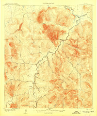 1907 Casadepaga1907 Print · USGSThe Seward Peninsula mining frontier is captured here at the height of early exploration, featuring the route of the Council City and Solomon River Railroad. Genealogists and historians can trace the early transit network and remote outposts like the Roadhouse and Mt Dixon.2 unique versions available
 - 1907 Map of Solomon
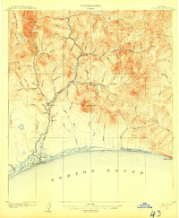 1907 Solomon1907 Print · USGSCoastal Alaska during the gold rush era reveals a landscape of rapid industrialization along the Norton Sound. You can trace the Council City and Solomon River RR from Solomon up to the Big Hurrah Mine and find numerous gold-bearing gulches.2 unique versions available
End of results
Showing maps 1-2 of 2
Top cities of Unorganized Borough
- Bethel historical maps
- Unalaska historical maps
- Valdez historical maps
- Nome historical maps
- Dillingham historical maps
- Cordova historical maps
See more
Frequently asked questions
- What are the different types of historical maps available for Unorganized Borough?
- What is the oldest map of Unorganized Borough?
- Where can I purchase historical maps of Unorganized Borough for my home or office?
- Where can I download high-res historical maps of Unorganized Borough?
- Are there historical topographic maps available for Unorganized Borough?
- Is there historical aerial imagery available for Unorganized Borough?
- Where are historical maps of Unorganized Borough sourced from?