1980s Maps of Unorganized Borough, Alaska
Explore 125 historic maps of Unorganized Borough from the 1980s. These maps offer a rare glimpse into what life looked like during the 1980s — showing old roads, neighborhoods, homes, and landmarks that have changed or disappeared over time.
Whether you're researching your family's past, planning a metal detecting trip, or studying how Unorganized Borough's landscape evolved across the 1980s, these high-resolution maps are a powerful tool for exploring the history of this region.
- Focus on a specific era: All maps on this page are from the 1980s, giving you a focused view of this time period.
- See what’s changed: Compare century-old streets, trails, and buildings to today's modern landscape using overlays and satellite layers.
- Research with precision: Use these maps for genealogy, historical research, land use analysis, or educational projects.
- View, download, or print: Maps are fully viewable online in high resolution, and can be downloaded or printed for your own records.
Start exploring Unorganized Borough's history through authentic maps from the 1980s. This is your window into the past.
Unorganized Borough, AK maps
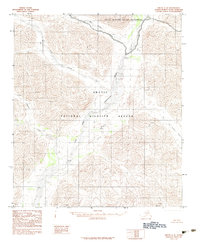
(125)- 1980 Map of Russian Mission
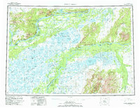 1980 Russian Mission1980 Print · USGSThe Yukon and Kuskokwim river basins are detailed here during the late twentieth century, showing a network of remote villages and seasonal camps. Researchers can trace traditional travel routes and settlements like Russian Mission, Chuathbaluk, and the historic Portage Trail.3 unique versions available
 - 1980 Map of Bethel
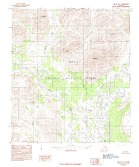
 1980 Bethel1980 Print · USGSThe Kuskokwim Delta and its riverbank villages are shown here in the early eighties as they relied on the water for transport and trade. Researchers can trace the layout of settlements like Bethel and Kwethluk or explore the wilderness around Chikuminuk Lake and Shining Dome.4 unique versions available
 - 1983 Map of Coleen C-6
 1983 Coleen C-61983 Print · USGSThe northern interior of Alaska is shown here in the early 1980s, shortly after the formal establishment of the Arctic National Wildlife Refuge. Researchers can trace the braided paths of the Sheenjek River and Koness River through this uninhabited wilderness.
 - 1983 Map of Valdez A-6 SW
 1983 Valdez A-6 SW1983 Print · USGSCoastal Alaska at the height of the early eighties energy boom shows the convergence of mountain terrain and industrial growth. Researchers can trace the path of the Trans-Alaska Pipeline and Richardson Highway past Robe Lake and the Valdez Marine Terminal.
 - 1983 Map of Valdez A-7 SE
 1983 Valdez A-7 SE1983 Print · USGSCoastal Alaska in the early eighties shows the intersection of the energy industry and a relocated community. Trace the massive Valdez Marine Terminal, the former Old Valdez (Site), and remote landmarks like the Midas Mine.
 - 1983 Map of Christian C-3
 1983 Christian C-31983 Print · USGSNorthern Alaska in the early eighties remains a wilderness of indigenous lands and conservation areas. Researchers can trace the path of the Winter Trail as it crosses the Venetie Indian Reservation and the Christian River.
 - 1983 Map of Cordova C-5 SW
 1983 Cordova C-5 SW1983 Print · USGSThe coastal community of Cordova is captured here in the early 1980s, showing the intersection of maritime life and mountain terrain. Trace the local infrastructure from the Ferry Terminal and Municipal Airport to the Copper River Highway and Orca.
 - 1983 Map of Valdez A-6 NW
 1983 Valdez A-6 NW1983 Print · USGSDevelopment near the Alaskan coast was expanding in the early eighties as shown in this detailed topographic study. Trace the reach of Valdez Glacier Stream past the Airport and local Mines near the Valdez Corporate Boundary.
 - 1983 Map of Cordova B-4 NW
 1983 Cordova B-4 NW1983 Print · USGSThe Copper River Delta is captured in the early 1980s, showing the intersection of heavy aviation infrastructure and wilderness. Researchers can trace the path of the Copper River Highway past Cordova Mile 13 Airport and through the vast Tiedeman Slough.
 - 1983 Map of Christian C-2
 1983 Christian C-21983 Print · USGSNorthern Alaska is shown here during the early eighties, centered on a pristine stretch of the Brooks Range. Researchers can trace the rugged drainage of Otter Creek through the protected boundaries of the Arctic National Wildlife Refuge.
 - 1983 Map of Cordova C-5 SE
 1983 Cordova C-5 SE1983 Print · USGSThe coastal environment near Cordova in the early 1980s reveals a wilderness of interconnected waterways and mountain peaks. Researchers can trace the route of the Copper River Highway as it navigates between Eyak Lake, Boy Scout Island, and the numerous tidal channels of the Eyak River.
 - 1983 Map of Cordova C-4 SW
 1983 Cordova C-4 SW1983 Print · USGSThe glacial landscapes of south-central Alaska are documented here in the early 1980s. You can trace the drainage of the Scott River and locate remote sites like the Cabin Lake Campground and the Siamese Lakes.
 - 1983 Map of Christian C-1
 1983 Christian C-11983 Print · USGSThe northern wilderness of the Brooks Range remains preserved in the early eighties within the Arctic National Wildlife Refuge. Researchers can trace the braided path of the Sheenjek River and locate landmarks like Helmet Mountain.
 - 1983 Map of Valdez A-6 SE
 1983 Valdez A-6 SE1983 Print · USGSThe Richardson Highway corridor south of Valdez appears in the early eighties as a vital transportation and energy artery. Trace the Trans-Alaska Pipeline through Keystone Canyon past Bridal Veil Falls and the Lowe River.
 - 1983 Map of Valdez A-7 NE
 1983 Valdez A-7 NE1983 Print · USGSThe coastal gateway of Valdez and its surrounding mining districts are shown in the early 1980s as the modern city took shape. Researchers can trace the industrial history of the Mineral Creek valley through the Hercules Mine, Smith Mill, and the Johnson Mill (Ruins).
 - 1983 Map of Arctic B-4, 1984 Print
 1983 Arctic B-41984 Print · USGSThe eastern Brooks Range foothills of the early eighties remain a roadless wilderness within the Arctic National Wildlife Refuge. Researchers can trace the winding Junjik River and locate remote peaks like Little Njoo Mountain and Misty Mountain.2 unique versions available
 - 1983 Map of Adak, 1984 Print
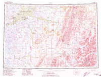
 1983 Adak1984 Print · USGSAdak Island during the early 1980s reveals the high-latitude infrastructure of a major Cold War naval installation. Researchers can trace the layout of the Adak Naval Station and Military Airport, alongside natural features like Mount Moffett and Finger Bay.
 - 1983 Map of Arctic C-1, 1984 Print
 1983 Arctic C-11984 Print · USGSThe remote interior of the North Slope is documented here in the early eighties, showcasing a landscape of raw drainage patterns. Researchers can trace the winding path of Old Woman Creek and the designated Wilderness Boundary within the Arctic National Wildlife Refuge.
 - 1983 Map of Arctic C-3, 1984 Print
 1983 Arctic C-31984 Print · USGSThe North Slope interior during the early eighties remains a pristine wilderness defined by the high peaks of the Brooks Range. Trace the path of the Continental Divide as it winds through the Arctic National Wildlife Refuge past Cane Creek and Flatrock Creek.
 - 1983 Map of Arctic B-2, 1984 Print
 1983 Arctic B-21984 Print · USGSThe wilderness of the Brooks Range is captured in the early 1980s as it appeared within the Arctic National Wildlife Refuge. Researchers can trace the remote waterways of the East Fork Chandalar River and locate landmarks like Salmon Mountain and Tetsyeh Lake.
 - 1983 Map of Table Mountain C-5, 1984 Print
 1983 Table Mountain C-51984 Print · USGSThe North Slope of Alaska in the early 1980s was a landscape defined by federal preservation and ancient waterways. Researchers can trace the winding Sheenjek River past landmarks like Double Mountain and the remote Ambresuajun Lake.
 - 1983 Map of Arctic C-2, 1984 Print
 1983 Arctic C-21984 Print · USGSThe North Slope during the early eighties shows a landscape of protected wilderness before modern digital mapping. Researchers can trace the wild drainages of the East Fork Chandalar River and its tributaries like Red Sheep Creek and Old Woman Creek.2 unique versions available
 - 1983 Map of Arctic B-3, 1984 Print
 1983 Arctic B-31984 Print · USGSAlaska's northern wilderness remains untouched in the early eighties within the Arctic National Wildlife Refuge. Researchers can trace the courses of the Junjik River and East Fork Chandalar River past Yasuda Mountain.3 unique versions available
 - 1983 Map of Arctic B-1, 1984 Print
 1983 Arctic B-11984 Print · USGSNorthern Alaska's interior wilderness is captured in the early 1980s as it appeared before the digital era. Researchers can trace the complex drainage of Old Woman Creek and the Koness River beneath the heights of Brushman Mountain.2 unique versions available
 - 1984 Map of Seward D-5 SE
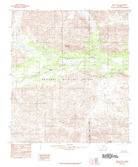
 1984 Seward D-5 SE1984 Print · USGSWhittier and the surrounding ice fields of the Prince William Sound are captured here in the mid-1980s. Researchers can trace the rugged coastline from the port at Passage Canal to the depths of Shotgun Cove and the massive Billings Glacier.
Showing maps 1-25 of 125
Top cities of Unorganized Borough
- Bethel historical maps
- Unalaska historical maps
- Valdez historical maps
- Nome historical maps
- Dillingham historical maps
- Cordova historical maps
See more
Frequently asked questions
- What are the different types of historical maps available for Unorganized Borough?
- What is the oldest map of Unorganized Borough?
- Where can I purchase historical maps of Unorganized Borough for my home or office?
- Where can I download high-res historical maps of Unorganized Borough?
- Are there historical topographic maps available for Unorganized Borough?
- Is there historical aerial imagery available for Unorganized Borough?
- Where are historical maps of Unorganized Borough sourced from?