1900s (20th Century) Maps of Phoenix, Arizona
Explore 61 historic maps of Phoenix from the 1900s (20th Century). These maps offer a rare glimpse into what life looked like during the 1900s — showing old roads, neighborhoods, homes, and landmarks that have changed or disappeared over time.
Whether you're researching your family's past, planning a metal detecting trip, or studying how Phoenix's landscape evolved across the 1900s, these high-resolution maps are a powerful tool for exploring the history of this region.
- Focus on a specific era: All maps on this page are from the 1900s, giving you a focused view of this time period.
- See what’s changed: Compare century-old streets, trails, and buildings to today's modern landscape using overlays and satellite layers.
- Research with precision: Use these maps for genealogy, historical research, land use analysis, or educational projects.
- View, download, or print: Maps are fully viewable online in high resolution, and can be downloaded or printed for your own records.
Start exploring Phoenix's history through authentic maps from the 1900s. This is your window into the past.
Phoenix, AZ maps
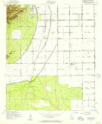
(61)- 1904 Map of Camelback
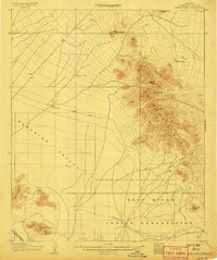
 1904 Camelback1904 Print · USGSMaricopa County is captured at the dawn of the twentieth century, showing a desert landscape before the rise of the Phoenix suburbs. Researchers can trace the foundational Arizona Canal and early landmarks like Camelback Mtn and Thompson Pk.
 - 1906 Map of Camelsback
 1906 Camelsback1906 Print · USGSArizona's high desert near Phoenix is captured here at the turn of the century, when the landscape was defined by mountain ranges and early water infrastructure. Genealogists and historians can trace the paths of the Old Verde Canal and the Arizona Canal or locate landmarks like Thompson Pk and Mountain Spring.3 unique versions available
 - 1912 Map of Phoenix, 1955 Print
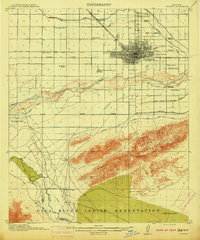
 1912 Phoenix1955 Print · USGSEarly 1900s Phoenix is depicted as an emerging agricultural and rail hub defined by its extensive canal system and desert surroundings. Genealogists and local researchers can trace early homesteads and community centers like Alhambra, St Johns Chapel, and the County Poor Farm.
 - 1913 Map of Mesa, 1955 Print
 1913 Mesa1955 Print · USGSMaricopa County's irrigation and early rail networks are meticulously detailed in this pre-war survey of the Salt River Valley. Genealogists can trace family names at local landmarks like Alma School, the settlement of Creamery, and the Kyrene School.
 - 1914 Map of Phoenix
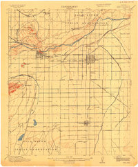
 1914 Phoenix1914 Print · USGSPhoenix and its surrounding valley are documented here at a pivotal moment of irrigation-driven growth before the mid-century boom. Genealogists and historians can locate early landmarks like the State Hospital, Maricopa Village, and numerous rural schoolhouses such as Isaac School and Fowler School.4 unique versions available
 - 1915 Map of Mesa
 1915 Mesa1915 Print · USGSMaricopa County's agricultural heartland was defined by a complex web of gravity-fed water systems before the era of modern expansion. Genealogists and historians can trace early settlements and school districts like Kyrene School, Falfa, and the Arizona State Normal School.2 unique versions available
 - 1930 Map of Cave Creek, 1959 Print
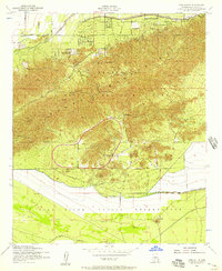
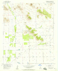
 1930 Cave Creek1959 Print · USGSThe Cave Creek and Verde River backcountry comes alive in this survey from the era of guest ranches and remote outposts. Researchers can locate early family homesteads like Lewis Ranch, trace the route to the Mormon Girl Mine, or find the original Spur Cross Dude Ranch.2 unique versions available
 - 1939 Map of Cave Creek
 1939 Cave Creek1939 Print · USGSThe Cave Creek area in the late thirties is a landscape of working cattle ranches and early desert tourism. Genealogists and historians can trace family-named outposts like Sears Kay Ranch and Browns Ranch or the historic Mormon Girl Mine.3 unique versions available
 - 1946 Map of Avondale, 1963 Print
 1946 Avondale1963 Print · USGSIn the postwar Salt River Valley, desert agriculture and military aviation began to reshape the landscape around Coldwater. Researchers can trace the early footprints of Litchfield Park, the U S Naval Air Facility, and rural sites like Liberty Siding.2 unique versions available
 - 1948 Map of Cashion
 1948 Cashion1948 Print · USGSMaricopa County's western valley is captured here in the late 1940s as agricultural irrigation and military aviation began to reshape the desert. Researchers can locate early schools and aviation landmarks like Pendergast Sch, the U S Naval Air Facility, and the state's geographic Initial Point.2 unique versions available
 - 1952 Map of Tempe, 1957 Print
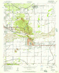 1952 Tempe1957 Print · USGSGreater Phoenix in the early fifties showcases a landscape defined by expansive irrigation canals and the rising campus of Arizona State College at Tempe. Genealogists and historians can trace the early borders of Scottsdale, the remote Tempe Airport, and the family plots within Guadalupe Cemetery.7 unique versions available
 - 1952 Map of Lone Butte, 1957 Print
 1952 Lone Butte1957 Print · USGSThe South Mountains meet the Gila River Indian Reservation in the early fifties, showing a desert landscape during a period of institutional growth. Trace the development of the Phoenix Proving Grounds, locate the Phoenix Police Academy, and find the isolated Lone Butte.5 unique versions available
 - 1952 Map of Laveen, 1957 Print
 1952 Laveen1957 Print · USGSThe Gila River Valley south of Phoenix comes to life in the early fifties, showing the desert as a patchwork of reservation lands and irrigation projects. Genealogists can locate specific homesteads near Komatke, the St Johns Indian Sch, and the riverside site of Gila Crossing.5 unique versions available
 - 1952 Map of Guadalupe, 1957 Print
 1952 Guadalupe1957 Print · USGSThe Salt River Valley's agricultural and industrial growth is captured here in the early fifties. Genealogists and historians can trace old settlements like Guadalupe and West Chandler alongside the Kyrene Steam Generating Plant and Southern Pacific rail line.6 unique versions available
 - 1952 Map of Phoenix, 1957 Print
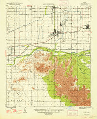
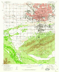
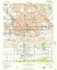 1952 Phoenix1957 Print · USGSPhoenix thrives in the early fifties as post-war growth transforms the Salt River Valley. Researchers can trace mid-century landmarks from Phoenix Municipal Airport to the historic Greenwood Cem and Encanto Park & Golf Course.5 unique versions available
 - 1952 Map of Fowler, 1957 Print
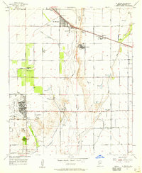
 1952 Fowler1957 Print · USGSThe western periphery of Phoenix was undergoing a major transition from desert ranching to irrigated farmland and industrial utility in the early fifties. Researchers can find numerous schools and cemeteries like Murphy Sch No 2, Work Circle Cem, and the specialized Valley of the Sun School.6 unique versions available
 - 1952 Map of Mesa, 1960 Print
 1952 Mesa1960 Print · USGSThe East Valley was a burgeoning network of irrigation canals and growing citrus towns in the early fifties. Genealogists and historians can trace old community centers like Sonora Town, Falfa, and Winfield Scott Sch alongside the early campus of Arizona State College.
 - 1952 Map of Phoenix, 1960 Print
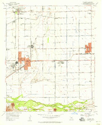
 1952 Phoenix1960 Print · USGSCentral Arizona's desert valley is shown in the early fifties as the city expands toward the Salt River. Genealogists can trace family names and sites from Maricopa Village to Alhambra, including local landmarks like St Johns Indian Sch.2 unique versions available
 - 1954 Map of Phoenix, 1964 Print
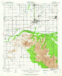
 1954 Phoenix1964 Print · USGSMid-century Arizona is captured here as the Phoenix metropolitan area begins its rapid expansion into the surrounding desert. Genealogists and historians can trace the development of agricultural hubs like Buckeye and Tolleson, or locate remote landmarks like the Vulture Mine and Nottbusch Cem.5 unique versions available
 - 1954 Map of Mesa, 1968 Print
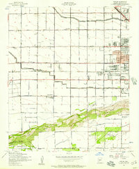
 1954 Mesa1968 Print · USGSCentral Arizona in the mid-fifties reveals the rapid growth of the Valley of the Sun alongside the deep-rooted mining districts of the eastern mountains. Genealogists and researchers can trace the expansion of Mesa and Chandler or locate legacy operations at Inspiration Mine and the Magma Arizona railroad.4 unique versions available
 - 1957 Map of Mesa
 1957 Mesa1957 Print · USGSCentral Arizona's desert valleys and high-mountain mining districts come alive in the mid-fifties. Researchers can trace the early layout of Mesa and Phoenix or locate remote sites like Inspiration Mine and Arizona State College.
 - 1957 Map of Phoenix
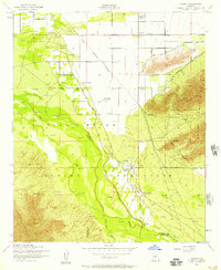
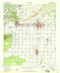
 1957 Phoenix1957 Print · USGSGreater Phoenix and the central Arizona desert during the mid-fifties reveal a landscape of growing suburbs and active desert mines. Researchers can trace the legacy of local landmarks like Wickenburg Prison, the Vulture Mine, and the Tonopah Post Office.
 - 1957 Map of El Mirage, 1958 Print
 1957 El Mirage1958 Print · USGSMaricopa County's West Valley comes into focus in the mid-fifties as agriculture and military aviation shape the desert landscape. Genealogists and historians can trace the early footprints of Surprise and El Mirage, or locate specific sites like the Heath Grave and the Dysart Sch.5 unique versions available
 - 1957 Map of Hedgpeth Hills, 1958 Print
 1957 Hedgpeth Hills1958 Print · USGSNorth of Glendale in the late fifties, this landscape shows the desert floor before total suburbanization. Genealogists and historians can trace the early irrigation and road networks around Sierra Vista School, the Arizona Canal, and Thunderbird Park.5 unique versions available
 - 1957 Map of Tolleson, 1958 Print
 1957 Tolleson1958 Print · USGSThe West Valley was a thriving agricultural hub in the late fifties, defined by its railroad towns and river junctions. Genealogists and local historians can trace the early footprints of Avondale, Goodyear, and Tolleson along the Southern Pacific line.5 unique versions available
Showing maps 1-25 of 61
Top cities near Phoenix
- Glendale historical maps
- Scottsdale historical maps
- Tempe historical maps
- Peoria historical maps
- Surprise historical maps
- Avondale historical maps
See more
Top neighborhoods of Phoenix
- Site historical maps
- Camelback East historical maps
- Rio Vista historical maps
- North Mountain historical maps
- North Gateway historical maps
- Estrella historical maps
See more
Frequently asked questions
- What are the different types of historical maps available for Phoenix?
- What is the oldest map of Phoenix?
- Where can I purchase historical maps of Phoenix for my home or office?
- Where can I download high-res historical maps of Phoenix?
- Are there historical topographic maps available for Phoenix?
- Is there historical aerial imagery available for Phoenix?
- Where are historical maps of Phoenix sourced from?