1920s Maps of Mohave County, Arizona
Explore 9 historic maps of Mohave County from the 1920s. These maps offer a rare glimpse into what life looked like during the 1920s — showing old roads, neighborhoods, homes, and landmarks that have changed or disappeared over time.
Whether you're researching your family's past, planning a metal detecting trip, or studying how Mohave County's landscape evolved across the 1920s, these high-resolution maps are a powerful tool for exploring the history of this region.
- Focus on a specific era: All maps on this page are from the 1920s, giving you a focused view of this time period.
- See what’s changed: Compare century-old streets, trails, and buildings to today's modern landscape using overlays and satellite layers.
- Research with precision: Use these maps for genealogy, historical research, land use analysis, or educational projects.
- View, download, or print: Maps are fully viewable online in high resolution, and can be downloaded or printed for your own records.
Start exploring Mohave County's history through authentic maps from the 1920s. This is your window into the past.
Mohave County, AZ maps
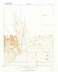
(9)- 1923 Map of Signal
 1923 Signal1923 Print · USGSWestern Arizona in the early twenties was a landscape of isolated mining camps and vital desert springs. Genealogists and historians can trace the footprint of early settlements like Signal and Swansea or locate remote outposts such as Owen and Butler well.
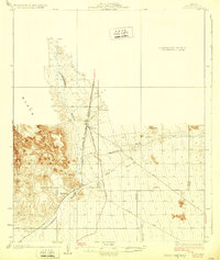
 - 1926 Map of Nelson
 1926 Nelson1926 Print · USGSThe Colorado River borderlands in the mid-twenties appear here as a landscape of desert canyons and future infrastructure. Researchers can trace the original river course through Eldorado Canyon and locate early sites like Nelson and the Middle Black Canyon Dam Site.
 - 1926 Map of Mohave City
 1926 Mohave City1926 Print · USGSThe Colorado River borderlands in the mid-twenties reveal a landscape of mining claims and early desert ranching before the era of modern dams. Researchers can trace the Arrowhead Trail south from Searchlight and locate family landmarks like the D Hutton Ranch or the Piute mine.
 - 1926 Map of Bonelli
 1926 Bonelli1926 Print · USGSThe Nevada-Arizona borderlands are captured here in the mid-1920s, showing the original river-crossing culture before the landscape was submerged. Researchers can trace the river economy through Bonelli Ferry, the settlement at St Thomas, and local mining at the Calico Salt Mine.
 - 1926 Map of Boulder Canyon
 1926 Boulder Canyon1926 Print · USGSBefore the completion of the Hoover Dam, this 1920s survey documents the Colorado River basin and its burgeoning infrastructure. Researchers can trace early railroad stops at Apex and Garnet, or locate the original Boulder Canyon Dam Site and Bonelli landing.2 unique versions available
 - 1927 Map of Yucca, 1965 Print
 1927 Yucca1965 Print · USGSThe Mojave Desert interior comes into focus during the late 1920s, showing the critical transport corridor through the valley. Trace the early automotive and rail routes that sustained Yucca, including the Old Trails Highway and the Atchison Topeka and Santa Fe Railway.
 - 1927 Map of Buck Mountains, 1966 Print
 1927 Buck Mountains1966 Print · USGSMohave County was a land of early highways and remote mining claims during the late 1920s. Trace the path of the National Old Trails Highway and locate mineral operations like the Palo Verde Mine and Arizona-Yucca Mine.
 - 1929 Map of Buck Mountains
 1929 Buck Mountains1929 Print · USGSMohave County’s desert mining and transit networks are documented here during the late twenties. Genealogists and historians can trace routes along the National Old Trails Highway or locate the Palo Verde Mine and Arizona-Yucca Mine.2 unique versions available
 - 1929 Map of Yucca
 1929 Yucca1929 Print · USGSWestern Arizona in the late 1920s was a landscape of remote rail sidings and early desert highways. Trace the intersection of the Atchison Topeka and Santa Fe Railway and the Old Trails Highway at Yucca, or find the settlement of Haviland along the Sacramento Wash.3 unique versions available
End of results
Showing maps 1-9 of 9
Top cities of Mohave County
- Lake Havasu City historical maps
- Bullhead City historical maps
- Kingman historical maps
- Fort Mohave historical maps
- New Kingman-Butler historical maps
- Golden Valley historical maps
See more
Frequently asked questions
- What are the different types of historical maps available for Mohave County?
- What is the oldest map of Mohave County?
- Where can I purchase historical maps of Mohave County for my home or office?
- Where can I download high-res historical maps of Mohave County?
- Are there historical topographic maps available for Mohave County?
- Is there historical aerial imagery available for Mohave County?
- Where are historical maps of Mohave County sourced from?