1940s Maps of Mohave County, Arizona
Explore 9 historic maps of Mohave County from the 1940s. These maps offer a rare glimpse into what life looked like during the 1940s — showing old roads, neighborhoods, homes, and landmarks that have changed or disappeared over time.
Whether you're researching your family's past, planning a metal detecting trip, or studying how Mohave County's landscape evolved across the 1940s, these high-resolution maps are a powerful tool for exploring the history of this region.
- Focus on a specific era: All maps on this page are from the 1940s, giving you a focused view of this time period.
- See what’s changed: Compare century-old streets, trails, and buildings to today's modern landscape using overlays and satellite layers.
- Research with precision: Use these maps for genealogy, historical research, land use analysis, or educational projects.
- View, download, or print: Maps are fully viewable online in high resolution, and can be downloaded or printed for your own records.
Start exploring Mohave County's history through authentic maps from the 1940s. This is your window into the past.
Mohave County, AZ maps
(9)- 1942 Map of Camp Mohave
 1942 Camp Mohave1942 Print · USGSThe tri-state borderlands of Nevada, Arizona, and California are captured here in the early 1940s, highlighting a landscape of deep canyons and high-desert mining camps. Researchers can trace historic rail lines and find remote outposts like Searchlight, Nelson, and the riverfront Fort Mohave Indian Reservation.
 - 1942 Map of Signal
 1942 Signal1942 Print · USGSNorthwestern Arizona was a rugged network of mining camps and river crossings during the early years of the war. Researchers can trace the isolated roads connecting Signal, the mines at Bagdad, and the remote desert outposts of Swansea and Alamo.
 - 1943 Map of Giers Basin
 1943 Giers Basin1943 Print · USGSThe Colorado River borderlands come into focus during the early years of the war, when this area served as a military maneuver zone. Researchers can locate desert water sources like Mohave Spring and Screwbean Spring or trace the early footprint of Parker Dam.
 - 1943 Map of Topock
 1943 Topock1943 Print · USGSThe Arizona-California borderlands are captured here during World War II, just as the landscape was being reshaped by the waters of the Colorado. Researchers can trace the original rail line through Topock and locate desert sidings like Franconia and Powell along the Sacramento Wash.
 - 1943 Map of Whipple Mts.
 1943 Whipple Mts.1943 Print · USGSThe Colorado River borderlands come into focus during the early years of the Second World War. Researchers can trace historic river access points and desert water sources like Liverpool Landing, Pittsburg Flat, and Whipple Well.
 - 1944 Map of Chloride
 1944 Chloride1944 Print · USGSThe Cerbat Mountains were a hive of mining and ranching activity in the late thirties. Researchers can trace the legacies of family outposts like Lewis Ranch and historic mining operations including the Tennessee Mine and the Stockton Mine.2 unique versions available
 - 1947 Map of Kingman, 1948 Print
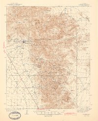
 1947 Kingman1948 Print · USGSThe tri-state Mojave desert region comes into focus during the late 1940s, as post-war travel began to surge along U S 66. Genealogists and historians can trace the mining-and-rail economy through the Atchison Topeka and Santa Fe line, the Copper World Mine, and old settlements like Oatman or Goodsprings.2 unique versions available
 - 1948 Map of Kingman
 1948 Kingman1948 Print · USGSThe Mojave Desert at the dawn of the fifties shows a landscape of deep canyons and booming mines along the Arizona and Nevada border. Genealogists and historians can trace rail-stop towns and mining claims like Oatman, Searchlight, and the Mohawk Mine.
 - 1948 Map of Williams
 1948 Williams1948 Print · USGSNorthern Arizona is captured here during the post-war era of roadside travel and heavy rail transport along the Santa Fe line. Researchers can trace the path of Route 66 through settlements like Seligman, Valentine, and Hackberry while exploring the vast terrain of the Hualpai Indian Reservation.2 unique versions available
End of results
Showing maps 1-9 of 9
Top cities of Mohave County
- Lake Havasu City historical maps
- Bullhead City historical maps
- Kingman historical maps
- Fort Mohave historical maps
- New Kingman-Butler historical maps
- Golden Valley historical maps
See more
Frequently asked questions
- What are the different types of historical maps available for Mohave County?
- What is the oldest map of Mohave County?
- Where can I purchase historical maps of Mohave County for my home or office?
- Where can I download high-res historical maps of Mohave County?
- Are there historical topographic maps available for Mohave County?
- Is there historical aerial imagery available for Mohave County?
- Where are historical maps of Mohave County sourced from?