1930s Maps of Schuk Toak District, Arizona
Explore 4 historic maps of Schuk Toak District from the 1930s. These maps offer a rare glimpse into what life looked like during the 1930s — showing old roads, neighborhoods, homes, and landmarks that have changed or disappeared over time.
Whether you're researching your family's past, planning a metal detecting trip, or studying how Schuk Toak District's landscape evolved across the 1930s, these high-resolution maps are a powerful tool for exploring the history of this region.
- Focus on a specific era: All maps on this page are from the 1930s, giving you a focused view of this time period.
- See what’s changed: Compare century-old streets, trails, and buildings to today's modern landscape using overlays and satellite layers.
- Research with precision: Use these maps for genealogy, historical research, land use analysis, or educational projects.
- View, download, or print: Maps are fully viewable online in high resolution, and can be downloaded or printed for your own records.
Start exploring Schuk Toak District's history through authentic maps from the 1930s. This is your window into the past.
Schuk Toak District, AZ maps
(4)- 1934 Map of Tucson Mountains
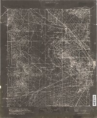 1934 Tucson Mountains1934 Print · USGSThe desert northwest of Tucson comes into focus during the mid-1930s, showing the early footprints of the Papago Indian Reservation and the railroad corridor. Genealogists and historians can trace family-named sites and ranching outposts like Maisi Ayra Ranch, Rodriguez, and the Maish Roadside Mine.
 - 1934 Map of Silver Bell
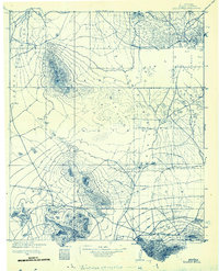 1934 Silver Bell1934 Print · USGSPima County at the height of the New Deal era reveals a sparse network of desert settlements and remote mines. Genealogists and historians can trace the footprint of the Papago Indian Reservation through its small villages like Santa Cruz and industrial sites like the Roadside Mine.
 - 1937 Map of Comobabi
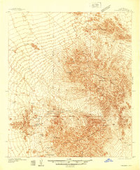 1937 Comobabi1937 Print · USGSPima County's high-desert mining and tribal lands are captured in the late 1930s, showing the early infrastructure of the Papago Indian Reservation. Trace the locations of isolated mining operations like the Cobabi Mine and settlements at San Luis and Nolic.4 unique versions available
 - 1938 Map of San Vicente, 1967 Print
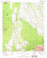 1938 San Vicente1967 Print · USGSThe high desert of Pima County comes into focus during the late 1930s, showcasing a network of remote ranching outposts and indigenous settlements. Researchers can trace the early Ajo-Tucson Highway to sites like Schuchk and the Roadside Mine.
End of results
Showing maps 1-4 of 4
Top neighborhoods of Schuk Toak District
- Quinlin historical maps
- Nawt Vaya historical maps
- San Pedro historical maps
- Uhs Kug historical maps
- San Vicente historical maps
- Queens Well historical maps
See more
Frequently asked questions
- What are the different types of historical maps available for Schuk Toak District?
- What is the oldest map of Schuk Toak District?
- Where can I purchase historical maps of Schuk Toak District for my home or office?
- Where can I download high-res historical maps of Schuk Toak District?
- Are there historical topographic maps available for Schuk Toak District?
- Is there historical aerial imagery available for Schuk Toak District?
- Where are historical maps of Schuk Toak District sourced from?