1980s Maps of Schuk Toak District, Arizona
Explore 7 historic maps of Schuk Toak District from the 1980s. These maps offer a rare glimpse into what life looked like during the 1980s — showing old roads, neighborhoods, homes, and landmarks that have changed or disappeared over time.
Whether you're researching your family's past, planning a metal detecting trip, or studying how Schuk Toak District's landscape evolved across the 1980s, these high-resolution maps are a powerful tool for exploring the history of this region.
- Focus on a specific era: All maps on this page are from the 1980s, giving you a focused view of this time period.
- See what’s changed: Compare century-old streets, trails, and buildings to today's modern landscape using overlays and satellite layers.
- Research with precision: Use these maps for genealogy, historical research, land use analysis, or educational projects.
- View, download, or print: Maps are fully viewable online in high resolution, and can be downloaded or printed for your own records.
Start exploring Schuk Toak District's history through authentic maps from the 1980s. This is your window into the past.
Schuk Toak District, AZ maps
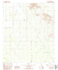
(7)- 1989 Map of Silver Bell West
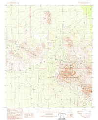 1989 Silver Bell West1989 Print · USGSMining and desert life intersect in Pima County during the late eighties, showing the industrial footprint of the El Tiro Mine. Genealogists and historians can trace old settlements at Silver Bell (Site) and locate the Silver Bell Cemetery.
 - 1989 Map of Queens Well
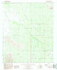 1989 Queens Well1989 Print · USGSThe Papago Indian Reservation comes into focus in the late 1980s, showcasing a landscape of desert ranching and seasonal water management. Trace the infrastructure of the Aguirre Valley through features like Queens Well and numerous Check Dams.
 - 1989 Map of Waterman Peak
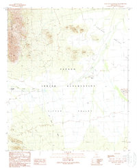
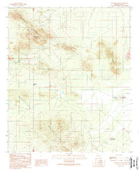 1989 Waterman Peak1989 Print · USGSDesert mining and the boundaries of the Papago Indian Reservation define this Pima County landscape in the late twentieth century. Researchers can trace historic mineral exploration through numerous prospects and mine shafts near Waterman Peak and Dos Titos.
 - 1989 Map of Koht Kohl Hill
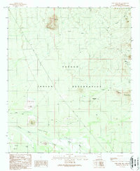 1989 Koht Kohl Hill1989 Print · USGSThe Papago Indian Reservation comes into focus during the late 1980s, revealing a desert landscape of ancient sites and mountain peaks. Genealogists and historians can locate the former positions of Skoksonak (Site) and Quinlin (Site) near Aguirre Wash.
 - 1989 Map of Santa Rosa Mountains SW
 1989 Santa Rosa Mountains SW1989 Print · USGSThe Papago Indian Reservation is captured here in the late 1980s, detailing a desert landscape of arid washes and high peaks. Researchers can identify local landmarks and water sources like the Makgum Havoka (Site), Mule Shoe Tank, and mining at Gu Achi Peak.
 - 1989 Map of Santa Rosa Mountains SE
 1989 Santa Rosa Mountains SE1989 Print · USGSThe Pima County desert as it was mapped in the late eighties shows a landscape of tribal lands and traditional water management. Researchers can trace the drainage of Sil Nakya Wash and locate the historic settlements at Hoi Oidak (Site) and Pipyak (Site).
 - 1989 Map of Gap Tank
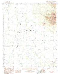
 1989 Gap Tank1989 Print · USGSSouthern Arizona’s high desert meets the foothills of the Silver Bells in the late eighties. Metal detectorists and historians can trace mining activity through several mine shafts and an adit near the Papago Indian Reservation.
End of results
Showing maps 1-7 of 7
Top neighborhoods of Schuk Toak District
- Quinlin historical maps
- Nawt Vaya historical maps
- San Pedro historical maps
- Uhs Kug historical maps
- San Vicente historical maps
- Queens Well historical maps
See more
Frequently asked questions
- What are the different types of historical maps available for Schuk Toak District?
- What is the oldest map of Schuk Toak District?
- Where can I purchase historical maps of Schuk Toak District for my home or office?
- Where can I download high-res historical maps of Schuk Toak District?
- Are there historical topographic maps available for Schuk Toak District?
- Is there historical aerial imagery available for Schuk Toak District?
- Where are historical maps of Schuk Toak District sourced from?