1930s Maps of St. Francis County, Arkansas
Explore 6 historic maps of St. Francis County from the 1930s. These maps offer a rare glimpse into what life looked like during the 1930s — showing old roads, neighborhoods, homes, and landmarks that have changed or disappeared over time.
Whether you're researching your family's past, planning a metal detecting trip, or studying how St. Francis County's landscape evolved across the 1930s, these high-resolution maps are a powerful tool for exploring the history of this region.
- Focus on a specific era: All maps on this page are from the 1930s, giving you a focused view of this time period.
- See what’s changed: Compare century-old streets, trails, and buildings to today's modern landscape using overlays and satellite layers.
- Research with precision: Use these maps for genealogy, historical research, land use analysis, or educational projects.
- View, download, or print: Maps are fully viewable online in high resolution, and can be downloaded or printed for your own records.
Start exploring St. Francis County's history through authentic maps from the 1930s. This is your window into the past.
St. Francis County, AR maps
(6)- 1931 Map of Horseshoe Lake
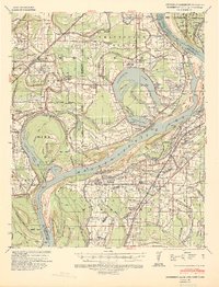
 1931 Horseshoe Lake1931 Print · USGSThe Mississippi Delta's shifting landscape is captured here in the early thirties, centered on the great oxbow of Horseshoe Lake. Genealogists and historians can trace family-named tracts like the Tucker Plantation and Seyppel Plantation, alongside rural landmarks like the Y M C A Camp and Robinsonville.
 - 1939 Map of Horseshoe Lake, 1941 Print
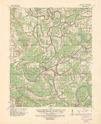
 1939 Horseshoe Lake1941 Print · USGSThe oxbows and plantations of the Mississippi delta are captured here in the late thirties as the river redefines state boundaries. Genealogists can locate named homesteads and community centers like the Abbey Leatherman Plantation, Robinsonville, and the Hopewell Sch & Ch.2 unique versions available
 - 1939 Map of Park Place, 1941 Print
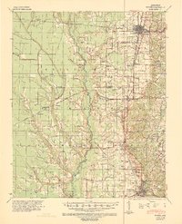
 1939 Park Place1941 Print · USGSThe Arkansas delta near the St. Francis and L'Anguille Rivers is shown here in the late 1930s as a thriving rail and river landscape. Genealogists can locate family names and rural centers like True Love Bar Ch & Sch, Rollinson, and the Marianna Helena Land Project.2 unique versions available
 - 1939 Map of Wynne, 1941 Print
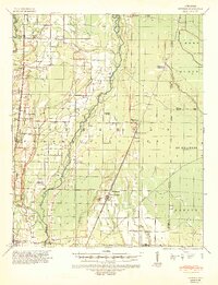
 1939 Wynne1941 Print · USGSEastern Arkansas at the end of the thirties was a region defined by the L'Anguille River and a thriving network of small rail towns and rural parishes. Researchers can trace ancestral roots through dozens of local landmarks like Wick Mill, Smith Chapel, and Bible Union Sch.2 unique versions available
 - 1939 Map of Hunter, 1942 Print
 1939 Hunter1942 Print · USGSWoodruff and Cross counties were at the peak of their rail-driven economy just before the war, when timber and agriculture dominated the Delta. Genealogists can trace family names at Odd Fellows Cem or locate rural landmarks like Hillmann Jr High Sch and the Whitehall Ch & Cem.2 unique versions available
 - 1939 Map of Edmondson, 1942 Print
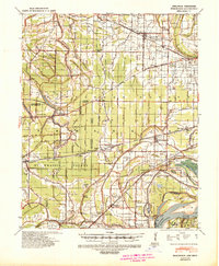 1939 Edmondson1942 Print · USGSCrittenden and St. Francis Counties are shown in the late thirties as a landscape of rail-connected farming towns and bayous. Genealogists can locate family landmarks like Garrett Cem, Macedonia Ch, and the combined Bellmeade Sch & Ch.
End of results
Showing maps 1-6 of 6
Top cities of St. Francis County
- Forrest City historical maps
- Hughes historical maps
- Madison historical maps
- Palestine historical maps
- Caldwell historical maps
- Colt historical maps
See more
Frequently asked questions
- What are the different types of historical maps available for St. Francis County?
- What is the oldest map of St. Francis County?
- Where can I purchase historical maps of St. Francis County for my home or office?
- Where can I download high-res historical maps of St. Francis County?
- Are there historical topographic maps available for St. Francis County?
- Is there historical aerial imagery available for St. Francis County?
- Where are historical maps of St. Francis County sourced from?