1990s Maps of St. Francis County, Arkansas
Explore 3 historic maps of St. Francis County from the 1990s. These maps offer a rare glimpse into what life looked like during the 1990s — showing old roads, neighborhoods, homes, and landmarks that have changed or disappeared over time.
Whether you're researching your family's past, planning a metal detecting trip, or studying how St. Francis County's landscape evolved across the 1990s, these high-resolution maps are a powerful tool for exploring the history of this region.
- Focus on a specific era: All maps on this page are from the 1990s, giving you a focused view of this time period.
- See what’s changed: Compare century-old streets, trails, and buildings to today's modern landscape using overlays and satellite layers.
- Research with precision: Use these maps for genealogy, historical research, land use analysis, or educational projects.
- View, download, or print: Maps are fully viewable online in high resolution, and can be downloaded or printed for your own records.
Start exploring St. Francis County's history through authentic maps from the 1990s. This is your window into the past.
St. Francis County, AR maps
(3)- 1990 Map of Brinkley, 1991 Print
 1990 Brinkley1991 Print · USGSEastern Arkansas at the start of the 1990s is defined by the agricultural rhythms of the Grand Prairie and the vital White River corridor. Genealogists and historians can trace the rail-linked growth of Brinkley and Des Arc alongside older landmarks like Peckerwood Lake.
 - 1990 Map of Helena, 1991 Print
 1990 Helena1991 Print · USGSThe Arkansas and Mississippi delta regions meet here in the 1990s, where the great river's oxbows and islands define the state line. Genealogists and historians can trace the rail networks of the Illinois Central Gulf RR and local settlements like Palestine, Marvell, and La Grange.
 - 1992 Map of Hawkins, 1993 Print
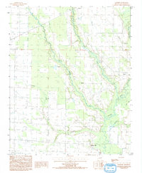 1992 Hawkins1993 Print · USGSSt. Francis County was characterized by its intricate river drainage and quiet rural settlements during the early 1990s. Genealogists and local historians can trace the locations of Slonikers Mill, Hawkins, and Pinetree along the banks of the L'Anguille River.
End of results
Showing maps 1-3 of 3
Top cities of St. Francis County
- Forrest City historical maps
- Hughes historical maps
- Madison historical maps
- Palestine historical maps
- Caldwell historical maps
- Colt historical maps
See more
Frequently asked questions
- What are the different types of historical maps available for St. Francis County?
- What is the oldest map of St. Francis County?
- Where can I purchase historical maps of St. Francis County for my home or office?
- Where can I download high-res historical maps of St. Francis County?
- Are there historical topographic maps available for St. Francis County?
- Is there historical aerial imagery available for St. Francis County?
- Where are historical maps of St. Francis County sourced from?