1970s Maps of St. Francis County, Arkansas
Explore 9 historic maps of St. Francis County from the 1970s. These maps offer a rare glimpse into what life looked like during the 1970s — showing old roads, neighborhoods, homes, and landmarks that have changed or disappeared over time.
Whether you're researching your family's past, planning a metal detecting trip, or studying how St. Francis County's landscape evolved across the 1970s, these high-resolution maps are a powerful tool for exploring the history of this region.
- Focus on a specific era: All maps on this page are from the 1970s, giving you a focused view of this time period.
- See what’s changed: Compare century-old streets, trails, and buildings to today's modern landscape using overlays and satellite layers.
- Research with precision: Use these maps for genealogy, historical research, land use analysis, or educational projects.
- View, download, or print: Maps are fully viewable online in high resolution, and can be downloaded or printed for your own records.
Start exploring St. Francis County's history through authentic maps from the 1970s. This is your window into the past.
St. Francis County, AR maps
(9)- 1971 Map of Wheatley, 1973 Print
 1971 Wheatley1973 Print · USGSWheatley and the surrounding St. Francis County wetlands are captured here in the early seventies as modern transit intersected traditional farm life. Genealogists can trace family names and community ties through sites like Monroe Academy, Pilgrim Rest Cem, and the cluster of Goodwin Cems.
 - 1971 Map of Fair Oaks, 1973 Print
 1971 Fair Oaks1973 Print · USGSFair Oaks and the surrounding Arkansas Delta are captured here in the early seventies, where rail lines and irrigation dominate the landscape. Researchers can trace the junction of two major railroads and locate sites like Penrose, Morton, and the Minnow Ponds.
 - 1971 Map of Brinkley, 1973 Print
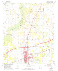 1971 Brinkley1973 Print · USGSBrinkley and the surrounding delta lowlands of Monroe County appear here at a peak of rail and aviation development in the 1970s. Genealogists and local historians can trace family roots at Macedonia Cem or locate community hubs like Wheatley Chapel and the Federer Memorial Airport.
 - 1971 Map of Garrett Grove, 1973 Print
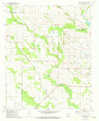 1971 Garrett Grove1973 Print · USGSThe Arkansas Delta comes into focus in the early seventies, detailing the rural intersections of Lee and Monroe counties. Researchers can trace family history through sites like Bemis Plantation, Moro Temple, and several local cemeteries including Long Cane Cemetery.
 - 1971 Map of Hunter East, 1973 Print
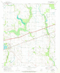
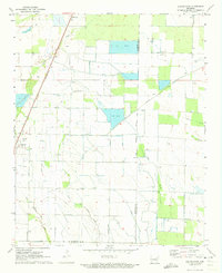 1971 Hunter East1973 Print · USGSIn the early 1970s, this portion of Woodruff and St. Francis Counties shows a landscape of intensive Delta farming and water management. Trace the path of the historic Military Road or locate the rural junction at Four Gums and the town of Hunter.2 unique versions available
 - 1971 Map of Hunter West, 1973 Print
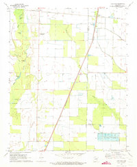
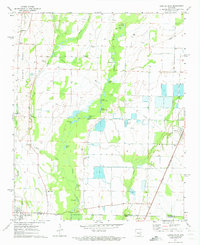 1971 Hunter West1973 Print · USGSWoodruff and Monroe counties in the early 1970s reveal a complex system of agricultural water management and small rural settlements. Trace the path of the St Louis Southwestern rail line or locate ancestral sites at Lake Grove Cem and Cotton Plant.3 unique versions available
 - 1975 Map of Horseshoe Lake NW, 1976 Print
 1975 Horseshoe Lake NW1976 Print · USGSThe Arkansas Delta near the Mississippi border comes into sharp focus in the mid-1970s, revealing a landscape of oxbow lakes and precision farming. Genealogists and local historians can trace the street layouts of Hughes and locate the rural settlement of Penjur near Council Lake.
 - 1975 Map of Edmondson SW, 1976 Print
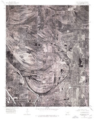
 1975 Edmondson SW1976 Print · USGSSt. Francis County in the mid-1970s is shown here through detailed aerial photography of its rural farming communities. Local historians can trace the landscape around Greasy Corner, Heth, and the winding course of Fifteenmile Bayou.
 - 1975 Map of Edmondson NW, 1976 Print
 1975 Edmondson NW1976 Print · USGSCrittenden County land and field patterns are revealed in high detail during the mid-seventies. Genealogists and local historians can trace rural homesteads near Hanover, the winding course of Blackfish Bayou, and settlements like Shearerville.
End of results
Showing maps 1-9 of 9
Top cities of St. Francis County
- Forrest City historical maps
- Hughes historical maps
- Madison historical maps
- Palestine historical maps
- Caldwell historical maps
- Colt historical maps
See more
Frequently asked questions
- What are the different types of historical maps available for St. Francis County?
- What is the oldest map of St. Francis County?
- Where can I purchase historical maps of St. Francis County for my home or office?
- Where can I download high-res historical maps of St. Francis County?
- Are there historical topographic maps available for St. Francis County?
- Is there historical aerial imagery available for St. Francis County?
- Where are historical maps of St. Francis County sourced from?