1900-1909 Maps of Colusa County, California
Explore 7 historic maps of Colusa County from 1900-1909. These maps offer a rare glimpse into what life looked like during the 1900s — showing old roads, neighborhoods, homes, and landmarks that have changed or disappeared over time.
Whether you're researching your family's past, planning a metal detecting trip, or studying how Colusa County's landscape evolved across the 1900s, these high-resolution maps are a powerful tool for exploring the history of this region.
- Focus on a specific era: All maps on this page are from the 1900s, giving you a focused view of this time period.
- See what’s changed: Compare century-old streets, trails, and buildings to today's modern landscape using overlays and satellite layers.
- Research with precision: Use these maps for genealogy, historical research, land use analysis, or educational projects.
- View, download, or print: Maps are fully viewable online in high resolution, and can be downloaded or printed for your own records.
Start exploring Colusa County's history through authentic maps from the 1900s. This is your window into the past.
Colusa County, CA maps
(7)- 1904 Map of Logan Creek, 1956 Print
 1904 Logan Creek1956 Print · USGSGlenn and Colusa counties meet in this 1904 survey where the valley floor meets the rising foothills. Researchers can trace the original seasonal drainage paths of Logan Creek and Hunters Creek through the early land partitions of the Northern Sacramento Valley.2 unique versions available
 - 1904 Map of Sites, 1957 Print
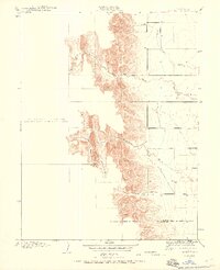
 1904 Sites1957 Print · USGSColusa County at the turn of the century shows a landscape shaped by early quarrying and the arrival of the rails. Genealogists and historians can trace the townsite of Sites, the local Cemetery, and the path of the Colusa and Lake railroad.2 unique versions available
 - 1905 Map of Harrington, 1956 Print
 1905 Harrington1956 Print · USGSThe Sacramento Valley at the start of the twentieth century was a landscape of rail-dependent agriculture and seasonal creeks. Genealogists and historians can trace the early layout of Harrington and the path of the Southern Pacific Railroad as it crosses from Colusa into Yolo County.
 - 1905 Map of Fairview, 1958 Print
 1905 Fairview1958 Print · USGSColusa County at the start of the century shows a landscape where early routes like the Colusa and Lake crossed the valley floor. Researchers can trace the drainage of Glenn Valley Slough and locate the historic settlement of Fairview.
 - 1906 Map of Maxwell
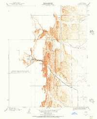
 1906 Maxwell1906 Print · USGSColusa and Glenn Counties at the dawn of the century show a landscape defined by massive land grants and new irrigation. Trace family roots and vanished river stops like Boggs Landing and Compton Landing along the Sacramento River.3 unique versions available
 - 1907 Map of Dunnigan
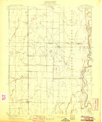
 1907 Dunnigan1907 Print · USGSThe Sacramento Valley in the early 1900s is defined by its busy river landings and the emerging rail corridor. Genealogists can trace family footprints at Zamora Blacks Station P O or follow the river to Cranmore Landing and Derby Camp.3 unique versions available
 - 1907 Map of Colusa
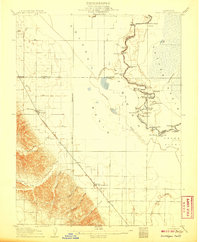
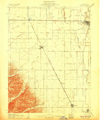 1907 Colusa1907 Print · USGSColusa County at the dawn of the twentieth century shows a landscape shaped by rail expansion and irrigation. Genealogists and historians can trace the early footprints of Colusa, Arbuckle, and College City, alongside the Southern Pacific R R and Sabin Lake.3 unique versions available
End of results
Showing maps 1-7 of 7
Top cities of Colusa County
Frequently asked questions
- What are the different types of historical maps available for Colusa County?
- What is the oldest map of Colusa County?
- Where can I purchase historical maps of Colusa County for my home or office?
- Where can I download high-res historical maps of Colusa County?
- Are there historical topographic maps available for Colusa County?
- Is there historical aerial imagery available for Colusa County?
- Where are historical maps of Colusa County sourced from?