1960s Maps of Colusa County, California
Explore 13 historic maps of Colusa County from the 1960s. These maps offer a rare glimpse into what life looked like during the 1960s — showing old roads, neighborhoods, homes, and landmarks that have changed or disappeared over time.
Whether you're researching your family's past, planning a metal detecting trip, or studying how Colusa County's landscape evolved across the 1960s, these high-resolution maps are a powerful tool for exploring the history of this region.
- Focus on a specific era: All maps on this page are from the 1960s, giving you a focused view of this time period.
- See what’s changed: Compare century-old streets, trails, and buildings to today's modern landscape using overlays and satellite layers.
- Research with precision: Use these maps for genealogy, historical research, land use analysis, or educational projects.
- View, download, or print: Maps are fully viewable online in high resolution, and can be downloaded or printed for your own records.
Start exploring Colusa County's history through authentic maps from the 1960s. This is your window into the past.
Colusa County, CA maps
(13)- 1960 Map of Ukiah
 1960 Ukiah1960 Print · USGSNorthern California during the late fifties reveals a landscape of deep timber forests and valley agriculture before modern expansion. Trace the historic rail lines of the California Western RR and the Northwestern Pacific RR through settlements like Fort Bragg and Ukiah.2 unique versions available
 - 1960 Map of Chico
 1960 Chico1960 Print · USGSThe Northern California high country and Sacramento Valley meet in this 1960s-era landscape of mining towns and river settlements. Trace the rail-and-water economy of the gold country through the Empire Mine, Beale Air Force Base, and the Western Pacific Railroad.
 - 1960 Map of Clearlake Oaks, 1962 Print
 1960 Clearlake Oaks1962 Print · USGSThe eastern shores of Clear Lake and the deep canyons of the Mendocino National Forest are captured here in the early sixties. Researchers can trace the layout of Sulphur Bank Rancheria or locate historic mineral sites like Bartlett Springs and Hough Springs.2 unique versions available
 - 1960 Map of Lodoga, 1962 Print
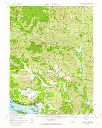
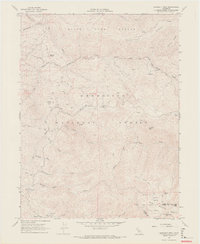
 1960 Lodoga1962 Print · USGSLodoga and the rugged ridges of the Colusa and Glenn county border are captured here in the early sixties. Genealogists and local historians can locate early rural landmarks like Little Stony Sch, Mills Orchards, and the historic Swifts Stone Corral.2 unique versions available
 - 1961 Map of Wilbur Springs, 1963 Print
 1961 Wilbur Springs1963 Print · USGSThe mining districts and remote ranchlands of Colusa and Lake Counties are documented here in the early sixties. Genealogists and industrial historians can trace the operations of the Abbott Mine and Clyde Mine, or locate vanished communities like Leesville and Skinnerville.2 unique versions available
 - 1962 Map of Santa Rosa
 1962 Santa Rosa1962 Print · USGSThe North Bay and Wine Country were entering a period of significant growth in the early sixties, anchored by established rail corridors and coastal maritime commerce. Genealogists and historians can trace the development of Santa Rosa, locate the Mare Island Naval Shipyard, and follow the Northwestern Pacific RR through the Cotati Valley.
 - 1964 Map of Santa Rosa
 1964 Santa Rosa1964 Print · USGSThe North Bay and Wine Country appear in the mid-fifties during a period of significant military and educational growth. Trace old rail lines like the Northwestern Pacific RR and explore historic sites from Petaluma to the Benicia Arsenal.
 - 1967 Map of Potato Hill, 1969 Print
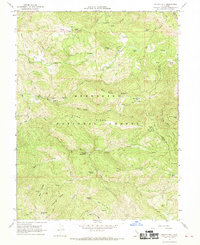 1967 Potato Hill1969 Print · USGSLake and Colusa counties appear as a rugged backcountry wilderness in the late sixties, dominated by the high ridgelines of the Mendocino National Forest. Researchers can trace remote historic sites like Snow Mountain House, find Crabtree Hot Springs, or locate old camps like Bear Creek Campground.3 unique versions available
 - 1967 Map of Crockett Peak, 1969 Print
 1967 Crockett Peak1969 Print · USGSThe Lake and Colusa county line runs through the Mendocino National Forest during the late sixties, where high peaks and mountain glades remained largely undeveloped. Trace the early backcountry network of Lower Nye Campground, Milk Ranch, and the primitive trails leading to Snow Mountain.4 unique versions available
 - 1968 Map of St. John Mtn., 1969 Print
 1968 St. John Mtn.1969 Print · USGSUpper Glenn County was a landscape of remote lookouts and wilderness camps in the late sixties. Researchers can trace the path of old jeep trails through the Mendocino National Forest to landmarks like Meyers Cabin and Upper Nye Camp.2 unique versions available
 - 1968 Map of Gilmore Peak, 1969 Print
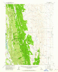
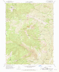
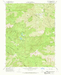
 1968 Gilmore Peak1969 Print · USGSWestern Colusa County in the late sixties reveals a landscape where national forest ridges meet the waters of the East Park Reservoir. Researchers can trace old mining efforts at the Ruby King Mine and locate local landmarks like the Stonyford Cem and Cooks Springs.
 - 1968 Map of Stonyford, 1969 Print
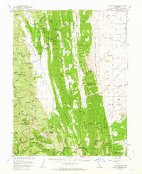
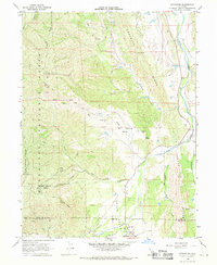 1968 Stonyford1969 Print · USGSStonyford and the eastern edges of the Coast Range appear here in the late sixties, where the valley ranching country meets the forest. Researchers can locate the Indian Valley Sch, trace Jeep Trails up Elephant Hill, or follow the waters of Stony Creek through the foothills.3 unique versions available
 - 1968 Map of Fouts Springs, 1970 Print
 1968 Fouts Springs1970 Print · USGSThe Mendocino National Forest in the late sixties was a landscape of remote camps and mountain water sources near the Lake and Colusa county line. Trace the network of pack trails connecting Fouts Springs, Sanborn Cabin, and the lookout at Goat Mountain.3 unique versions available
End of results
Showing maps 1-13 of 13
Top cities of Colusa County
Frequently asked questions
- What are the different types of historical maps available for Colusa County?
- What is the oldest map of Colusa County?
- Where can I purchase historical maps of Colusa County for my home or office?
- Where can I download high-res historical maps of Colusa County?
- Are there historical topographic maps available for Colusa County?
- Is there historical aerial imagery available for Colusa County?
- Where are historical maps of Colusa County sourced from?