1940s Maps of Colusa County, California
Explore 14 historic maps of Colusa County from the 1940s. These maps offer a rare glimpse into what life looked like during the 1940s — showing old roads, neighborhoods, homes, and landmarks that have changed or disappeared over time.
Whether you're researching your family's past, planning a metal detecting trip, or studying how Colusa County's landscape evolved across the 1940s, these high-resolution maps are a powerful tool for exploring the history of this region.
- Focus on a specific era: All maps on this page are from the 1940s, giving you a focused view of this time period.
- See what’s changed: Compare century-old streets, trails, and buildings to today's modern landscape using overlays and satellite layers.
- Research with precision: Use these maps for genealogy, historical research, land use analysis, or educational projects.
- View, download, or print: Maps are fully viewable online in high resolution, and can be downloaded or printed for your own records.
Start exploring Colusa County's history through authentic maps from the 1940s. This is your window into the past.
Colusa County, CA maps
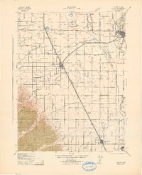
(14)- 1941 Map of Dunnigan
 1941 Dunnigan1941 Print · USGSYolo and Sutter counties are captured here in the early 1940s, showing a landscape defined by the shifting Sacramento River and the Southern Pacific rail line. Trace the history of river commerce at Rough and Ready Landing or locate family roots in Zamora Blacks Station P O and Dunnigan.
 - 1942 Map of Butte Sink
 1942 Butte Sink1942 Print · USGSNorthern California's agricultural heartland is documented here during the early war years, showing the intersection of four counties. Researchers can locate family landmarks like Marvin Chapel and trace the rural school system at Harmony Sch and Butte Sch.
 - 1942 Map of Colusa
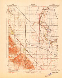
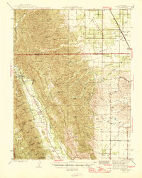
 1942 Colusa1942 Print · USGSColusa County at the start of the 1940s reveals a highly engineered agricultural landscape defined by vital rail lines and irrigation works. Genealogists and local historians can trace the development of Williams, the rural Central Sch, and smaller sidings like Cortena and Delphos along the Southern Pacific.
 - 1942 Map of Bartlett Springs
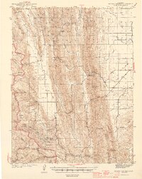
 1942 Bartlett Springs1942 Print · USGSLake County and the rugged North Coast Ranges are captured here in the early 1940s, balancing resort springs with hardscrabble ranching. Genealogists can locate family landmarks like Garner Ranch, the East Lake Sch, and the isolated Bartlett Springs resort.
 - 1943 Map of Morgan Valley
 1943 Morgan Valley1943 Print · USGSNorthern California ranching and mining country are captured in the early 1940s at the junction of Lake, Napa, and Yolo counties. Researchers can locate the Morgan Valley Sch and several mines like the Harrison Mine and Red Elephant Mine.
 - 1943 Map of Lodoga
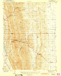 1943 Lodoga1943 Print · USGSThe foothills of the Sacramento Valley were undergoing a transformation during the 1940s as irrigation reached the plains. Researchers can locate the settlement of Sites, the Black Mtn Sch, and early fruit production at Mills Orchards.2 unique versions available
 - 1944 Map of Bartlett Springs
 1944 Bartlett Springs1944 Print · USGSLake County at the height of the war years reveals a landscape of isolated springs and family-run ranches nestled along the high ridges. Researchers can trace historic homesteads like the Garner Ranch, the site of Bartlett Springs, and the East Lake Sch near the Clear Lake shoreline.2 unique versions available
 - 1944 Map of Wilbur Springs
 1944 Wilbur Springs1944 Print · USGSNorthern California mining country comes to life in this mid-forties survey of the Coast Ranges. Researchers can trace the quicksilver industry through sites like Abbott Mine and locate rural family history at Leesville or the Huffmaster Ranch.3 unique versions available
 - 1944 Map of Morgan Valley
 1944 Morgan Valley1944 Print · USGSUpper California ranching and mercury mining country are shown here in the mid-1940s near the corner of Lake, Colusa, and Napa counties. Researchers can trace historic operations like Reid Mine, the old Morgan Valley Sch, and local hubs like Knoxville.2 unique versions available
 - 1945 Map of Rumsey
 1945 Rumsey1945 Print · USGSThe Capay Valley and northern Sacramento Valley meet here in the mid-1940s, showing a landscape of secluded canyons and rail-side settlements. Genealogists can trace family footprints near Rumsey, Guinda, and rural schoolhouses like Wildwood Sch.2 unique versions available
 - 1947 Map of Santa Rosa
 1947 Santa Rosa1947 Print · USGSNorthern California in the late 1940s was a landscape of agricultural valleys and vital rail hubs. Trace the historic routes of the Northwestern Pacific through Healdsburg or explore the mid-century waterfronts of Vallejo and Benicia near Mare Island.
 - 1947 Map of Sacramento, 1948 Print
 1947 Sacramento1948 Print · USGSThe Sacramento Valley meets the high Sierra during a period of post-war expansion. Trace the historic river delta islands like Grand Island or locate early airfield footprints at McClellan Air Force Base and Mather Air Force Base.2 unique versions available
 - 1948 Map of Sacramento, 1951 Print
 1948 Sacramento1951 Print · USGSPost-war Northern California comes alive in this regional survey, capturing the era of expansion between the Central Valley and the High Sierra. Researchers can trace the rail networks of the Central California Traction and Sacramento Northern RR or locate landmarks like the State Capitol and University of California Davis.
 - 1949 Map of Santa Rosa
 1949 Santa Rosa1949 Print · USGSThe North Bay and Wine Country appear here in the late 1940s, when the Northwestern Pacific RR still dominated regional transit. Genealogists and historians can trace old coastal outposts like Anchor Bay Settlement and the early layout of Santa Rosa.2 unique versions available
End of results
Showing maps 1-14 of 14
Top cities of Colusa County
Frequently asked questions
- What are the different types of historical maps available for Colusa County?
- What is the oldest map of Colusa County?
- Where can I purchase historical maps of Colusa County for my home or office?
- Where can I download high-res historical maps of Colusa County?
- Are there historical topographic maps available for Colusa County?
- Is there historical aerial imagery available for Colusa County?
- Where are historical maps of Colusa County sourced from?