1970s Maps of Fresno County, California
Explore 5 historic maps of Fresno County from the 1970s. These maps offer a rare glimpse into what life looked like during the 1970s — showing old roads, neighborhoods, homes, and landmarks that have changed or disappeared over time.
Whether you're researching your family's past, planning a metal detecting trip, or studying how Fresno County's landscape evolved across the 1970s, these high-resolution maps are a powerful tool for exploring the history of this region.
- Focus on a specific era: All maps on this page are from the 1970s, giving you a focused view of this time period.
- See what’s changed: Compare century-old streets, trails, and buildings to today's modern landscape using overlays and satellite layers.
- Research with precision: Use these maps for genealogy, historical research, land use analysis, or educational projects.
- View, download, or print: Maps are fully viewable online in high resolution, and can be downloaded or printed for your own records.
Start exploring Fresno County's history through authentic maps from the 1970s. This is your window into the past.
Fresno County, CA maps
(5)- 1970 Map of Burrel
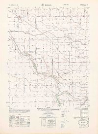 1970 Burrel1970 Print · USGSAgricultural and industrial growth converge in Fresno County at the start of the seventies. Genealogists and historians can trace the irrigation networks of Murphy Slough and locate sites like Bender Union Sch or the Oil Field near Lanare.
 - 1974 Map of Monterey, 1977 Print
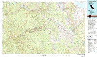
 1974 Monterey1977 Print · USGSThe Central Coast and San Joaquin Valley meet in this mid-seventies survey of the Monterey region. Genealogists and historians can locate Spanish-era sites like the San Antonio de Padua Mission, early industrial markers such as the New Idria Mine, and coastal landmarks like the Point Sur Lighthouse.
 - 1976 Map of Yosemite Valley, 1994 Print
 1976 Yosemite Valley1994 Print · USGSThe High Sierra and the iconic Yosemite Valley are captured here during the 1970s, showing the primary road networks and backcountry trails of the day. Researchers can trace the layout of Yosemite Village or locate historic mining sites like Schroeder Mine and Buffalo Mine.2 unique versions available
 - 1978 Map of Mount Whitney, 1992 Print
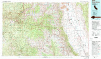 1978 Mount Whitney1992 Print · USGSThe high Sierra and Owens Valley meet in the late 1970s, showcasing the transition from alpine wilderness to valley floor settlements. Trace historical mining operations like the Green Monster Mine or find early routes to the summit near Whitney Portal.
 - 1978 Map of Bishop, 1994 Print
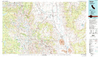 1978 Bishop1994 Print · USGSThe Owens Valley and Eastern Sierra come alive in this late seventies study, documenting a landscape shaped by mining and high-altitude water storage. Local researchers can trace family names and industry at Pine Creek Mine, Scheelite, and Lucky Strike Mine.2 unique versions available
End of results
Showing maps 1-5 of 5
Top cities of Fresno County
- Fresno historical maps
- Clovis historical maps
- Reedley historical maps
- Sanger historical maps
- Selma historical maps
- Coalinga historical maps
See more
Frequently asked questions
- What are the different types of historical maps available for Fresno County?
- What is the oldest map of Fresno County?
- Where can I purchase historical maps of Fresno County for my home or office?
- Where can I download high-res historical maps of Fresno County?
- Are there historical topographic maps available for Fresno County?
- Is there historical aerial imagery available for Fresno County?
- Where are historical maps of Fresno County sourced from?