1970s Maps of Imperial County, California
Explore 6 historic maps of Imperial County from the 1970s. These maps offer a rare glimpse into what life looked like during the 1970s — showing old roads, neighborhoods, homes, and landmarks that have changed or disappeared over time.
Whether you're researching your family's past, planning a metal detecting trip, or studying how Imperial County's landscape evolved across the 1970s, these high-resolution maps are a powerful tool for exploring the history of this region.
- Focus on a specific era: All maps on this page are from the 1970s, giving you a focused view of this time period.
- See what’s changed: Compare century-old streets, trails, and buildings to today's modern landscape using overlays and satellite layers.
- Research with precision: Use these maps for genealogy, historical research, land use analysis, or educational projects.
- View, download, or print: Maps are fully viewable online in high resolution, and can be downloaded or printed for your own records.
Start exploring Imperial County's history through authentic maps from the 1970s. This is your window into the past.
Imperial County, CA maps
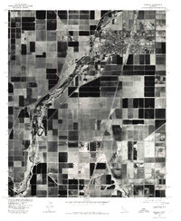
(6)- 1976 Map of Calipatria
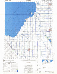 1976 Calipatria1976 Print · USGSThe Imperial Valley landscape in the mid-seventies is defined here by the receding Salton Sea and a vast irrigation grid. Trace the routes of the Southern Pacific through Calipatria and explore local landmarks like the Mud Pots and Vail Ranch.
 - 1976 Map of Brawley, 1980 Print
 1976 Brawley1980 Print · USGSThe Imperial Valley's desert agriculture is revealed in mid-1970s detail as Brawley thrives amidst a vast irrigation network. Genealogists and local historians can trace the town's street grid and the path of the New River past landmarks like the Dolson Drain.
 - 1976 Map of Calexico, 1980 Print
 1976 Calexico1980 Print · USGSThe borderlands of the Imperial Valley come into focus in the mid-1970s, showcasing the intricate relationship between agriculture and urban growth. Trace the path of the All American canal and the dense streets of Calexico at the edge of Mexico.
 - 1976 Map of El Centro, 1980 Print
 1976 El Centro1980 Print · USGSThe Imperial Valley agricultural landscape comes into focus in this mid-seventies aerial study of the desert's edge. Trace the irrigation networks of the Central Main Canal and the Dogwood Canal as they serve El Centro.
 - 1978 Map of Durmid, 1987 Print
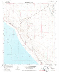 1978 Durmid1987 Print · USGSThe desert shoreline of the Salton Sea in the late seventies reveals a landscape of industrial transit and military boundaries. Researchers can trace the Southern Pacific rail stops at Ferrum and Durmid, or locate the remote Bertram Mine near the county line.
 - 1979 Map of El Cajon
 1979 El Cajon1979 Print · USGSSouthern San Diego County and its mountain-to-desert transition are captured here in the late seventies. Researchers can trace the winding San Diego & Arizona Eastern RR, locate rural settlements like Jacumba, and explore the sprawling Cleveland National Forest.2 unique versions available
End of results
Showing maps 1-6 of 6
Top cities of Imperial County
- El Centro historical maps
- Calexico historical maps
- Brawley historical maps
- Imperial historical maps
- Calipatria historical maps
- Holtville historical maps
See more
Frequently asked questions
- What are the different types of historical maps available for Imperial County?
- What is the oldest map of Imperial County?
- Where can I purchase historical maps of Imperial County for my home or office?
- Where can I download high-res historical maps of Imperial County?
- Are there historical topographic maps available for Imperial County?
- Is there historical aerial imagery available for Imperial County?
- Where are historical maps of Imperial County sourced from?