1980s Maps of Imperial County, California
Explore 27 historic maps of Imperial County from the 1980s. These maps offer a rare glimpse into what life looked like during the 1980s — showing old roads, neighborhoods, homes, and landmarks that have changed or disappeared over time.
Whether you're researching your family's past, planning a metal detecting trip, or studying how Imperial County's landscape evolved across the 1980s, these high-resolution maps are a powerful tool for exploring the history of this region.
- Focus on a specific era: All maps on this page are from the 1980s, giving you a focused view of this time period.
- See what’s changed: Compare century-old streets, trails, and buildings to today's modern landscape using overlays and satellite layers.
- Research with precision: Use these maps for genealogy, historical research, land use analysis, or educational projects.
- View, download, or print: Maps are fully viewable online in high resolution, and can be downloaded or printed for your own records.
Start exploring Imperial County's history through authentic maps from the 1980s. This is your window into the past.
Imperial County, CA maps
(27)- 1982 Map of Borrego Valley, 1983 Print
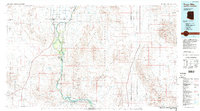
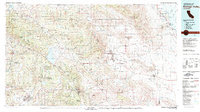 1982 Borrego Valley1983 Print · USGSThe high desert and coastal mountains of San Diego County come together in the early eighties. Researchers can trace the boundaries of the Los Coyotes Indian Reservation or locate the Desert Queen Mine and Palomar Observatory.2 unique versions available
 - 1983 Map of Wiley Well
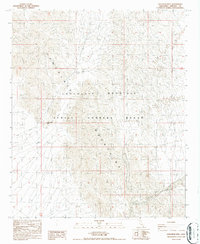
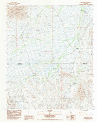 1983 Wiley Well1983 Print · USGSRiverside and Imperial Counties were largely defined by desert transit and mineral exploration in the early 1980s. You can trace the historic Bradshaw Trail and locate sites of interest like the Geode Beds and the Mine Shaft near the county line.
 - 1983 Map of Thumb Peak
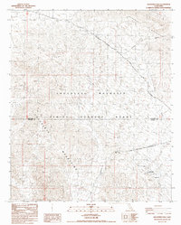
 1983 Thumb Peak1983 Print · USGSThe Riverside and Imperial county line area was a landscape of mining and desert trails in the early eighties. You can trace the historic Bradshaw Trail, locate the Opal Hill Mine, and find water sources like Clapp Spring.2 unique versions available
 - 1985 Map of Salton Sea
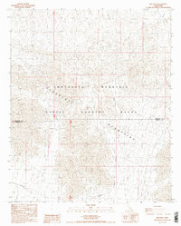
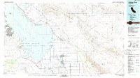 1985 Salton Sea1985 Print · USGSIn the mid-1980s, the California desert around the Salton Sea shows a unique mix of military gunnery ranges, irrigated agriculture, and shoreline settlements. Trace the Southern Pacific rail route through Niland and Bombay Beach, or locate remote desert sites like the Black Eagle Mine.2 unique versions available
 - 1986 Map of Red Hill SW
 1986 Red Hill SW1986 Print · USGSIn the mid-1980s, the desert near the California border served as both a military testing site and a wildlife sanctuary. Researchers can trace the boundaries of the Yuma Proving Ground and locate river landmarks like Mc Allister Lake and the Observation Tower.
 - 1986 Map of Trigo Mts
 1986 Trigo Mts1986 Print · USGSThe Colorado River corridor is captured here in the mid-eighties as it winds between Arizona and California. Researchers can trace decades of desert enterprise through locations like Paymaster Mine, the Cibola National Wildlife Refuge, and Walters Camp.2 unique versions available
 - 1986 Map of Lion Head Mountain, 1987 Print
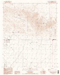
 1986 Lion Head Mountain1987 Print · USGSImperial County’s desert landscape is captured in the 1980s during its era as a strategic military training ground. Researchers can trace remote routes like the Blythe Niland Road and locate historical landmarks like Beal Well and Lion Head Mtn.3 unique versions available
 - 1987 Map of Augustine Pass
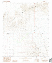
 1987 Augustine Pass1987 Print · USGSThe Colorado Desert during the 1980s reveals a landscape of military restricted zones and ancient transit corridors. You can trace the historic Bradshaw Road and locate remote passages like Augustine Pass and Surveyors Pass through the high ridgelines.
 - 1987 Map of Iris Pass
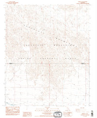
 1987 Iris Pass1987 Print · USGSThe high desert of Riverside and Imperial counties in the late eighties is defined by its restricted military zones and steep topography. Trace the drainage of Iris Wash through the Chocolate Mountains and the boundaries of the Chocolate Mountain Aerial Gunnery Range.2 unique versions available
 - 1988 Map of West of Palo Verde Peak
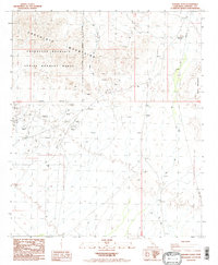
 1988 West of Palo Verde Peak1988 Print · USGSIn the desert of Imperial County during the late 1980s, this survey shows a remote landscape of military ranges and mineral prospects. Researchers can trace the path of Milpitas Wash and identify numerous Prospect sites near the Smoketree Valley.
 - 1988 Map of Buzzards Peak
 1988 Buzzards Peak1988 Print · USGSImperial County's high desert was a site of persistent mineral exploration in the late twentieth century. Researchers can trace the network of 4WD tracks leading to various Mines and Prospects near Gold Basin and Buzzards Peak.2 unique versions available
 - 1988 Map of Chuckwalla Spring
 1988 Chuckwalla Spring1988 Print · USGSThe high desert of Riverside and Imperial Counties in the late 1980s reveals a landscape of mining prospects and military reservations. Trace the 4WD tracks and trails through Graham Pass to find isolated water sources like Chuckwalla Spring and Indian Well.2 unique versions available
 - 1988 Map of Palo Verde Peak
 1988 Palo Verde Peak1988 Print · USGSImperial County's arid back-country is captured in the late 1980s, showcasing the intricate topography of the Palo Verde Mountains. Metal detectorists and desert researchers can trace old 4WD routes to remote prospects and a Mine near the southern edge of Milpitas Wash.
 - 1988 Map of Little Chuckwalla Mountains
 1988 Little Chuckwalla Mountains1988 Print · USGSThe high desert border of Riverside and Imperial counties is documented here in the late eighties. Geologists and rockhounds can locate the Geode Beds and trace old 4WD routes and mining prospects through the Little Chuckwalla Mountains.3 unique versions available
 - 1988 Map of Pegleg Well
 1988 Pegleg Well1988 Print · USGSImperial County's desert mining and military history converge in the late eighties among these arid peaks. Genealogists and desert historians can trace the locations of the Pegleg Mine, the eponymous Pegleg Well, and the historical German Diggins.
 - 1988 Map of Hedges
 1988 Hedges1988 Print · USGSMining history and desert settlements define this Imperial County landscape in the 1980s. Local researchers can trace the footprint of the Tumco Mine, identify the former location of Hedges, and find the Cem near the Cargo Muchacho Mountains.
 - 1988 Map of Little Mule Mountains
 1988 Little Mule Mountains1988 Print · USGSThe Colorado Desert of Imperial County in the late eighties reveals a landscape of tactical training and natural drainage. Researchers can trace the boundaries of the Aerial Gunnery Range and the paths of Milpitas Wash and Arroyo Seco.2 unique versions available
 - 1988 Map of Frink NE
 1988 Frink NE1988 Print · USGSRiverside and Imperial counties are shown in the late eighties as a landscape of military testing and desert infrastructure. Researchers can trace the path of the Coachella Canal and identify the boundaries of the expansive Aerial Gunnery Range.3 unique versions available
 - 1988 Map of Ogilby
 1988 Ogilby1988 Print · USGSImperial County's desert mining heritage is frozen in time during the late 1980s, centered on the rugged peaks of the Cargo Mucho Mountains. Researchers can map the old Ogilby (Site) and trace numerous extraction operations like the American Girl Mine and Cargo Mine.
 - 1988 Map of East of Acolita
 1988 East of Acolita1988 Print · USGSImperial County's desert interior in the late eighties reveals a specialized landscape of military training and resource extraction. Researchers can trace the perimeter of the Aerial Gunnery Range and locate numerous Gravel Pit sites and the Algodones Sand Dunes.2 unique versions available
 - 1988 Map of Mammoth Wash
 1988 Mammoth Wash1988 Print · USGSThe high desert of Imperial County is captured in the late eighties, showing a landscape defined by restricted military use. Researchers can trace the perimeter of the Aerial Gunnery Range and follow the paths of German Diggins Wash and Mammoth Wash.
 - 1988 Map of Mt. Barrow
 1988 Mt. Barrow1988 Print · USGSImperial County in the late eighties reveals a desert landscape shaped by military activity and mineral exploration. Genealogists and historians can trace old mining sites like Paymaster Mine and the remote settlement at Imperial Gables.
 - 1988 Map of Ninemile Wash
 1988 Ninemile Wash1988 Print · USGSImperial County mining and military lands are captured here during the 1980s, revealing a landscape of active extraction and desert wilderness. Metal detectorists and historians can trace routes to the Mesquite Mine, the Old Channel Mine Shaft, and various prospects along Ninemile Wash.2 unique versions available
 - 1988 Map of Clyde
 1988 Clyde1988 Print · USGSImperial County's desert interior is documented here in the late eighties, featuring the transition from the Pilot Knob Mesa to the shifting Sand Dunes. Local researchers can locate the remote settlement of Clyde and trace desert hydrology along Indian Wash.
 - 1988 Map of Quartz Peak
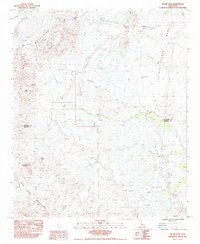
 1988 Quartz Peak1988 Print · USGSImperial County's desert peaks and deep canyon washes are meticulously documented in the late eighties as they appeared before modern development. Researchers can locate remote mining Prospects and vital desert landmarks like the Peter Kane Water Hole and Indian Pass.
Showing maps 1-25 of 27
Top cities of Imperial County
- El Centro historical maps
- Calexico historical maps
- Brawley historical maps
- Imperial historical maps
- Calipatria historical maps
- Holtville historical maps
See more
Frequently asked questions
- What are the different types of historical maps available for Imperial County?
- What is the oldest map of Imperial County?
- Where can I purchase historical maps of Imperial County for my home or office?
- Where can I download high-res historical maps of Imperial County?
- Are there historical topographic maps available for Imperial County?
- Is there historical aerial imagery available for Imperial County?
- Where are historical maps of Imperial County sourced from?