1920s Maps of Bakersfield, California
Explore 3 historic maps of Bakersfield from the 1920s. These maps offer a rare glimpse into what life looked like during the 1920s — showing old roads, neighborhoods, homes, and landmarks that have changed or disappeared over time.
Whether you're researching your family's past, planning a metal detecting trip, or studying how Bakersfield's landscape evolved across the 1920s, these high-resolution maps are a powerful tool for exploring the history of this region.
- Focus on a specific era: All maps on this page are from the 1920s, giving you a focused view of this time period.
- See what’s changed: Compare century-old streets, trails, and buildings to today's modern landscape using overlays and satellite layers.
- Research with precision: Use these maps for genealogy, historical research, land use analysis, or educational projects.
- View, download, or print: Maps are fully viewable online in high resolution, and can be downloaded or printed for your own records.
Start exploring Bakersfield's history through authentic maps from the 1920s. This is your window into the past.
Bakersfield, CA maps
(3)- 1929 Map of Stevens
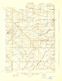 1929 Stevens1929 Print · USGSThe Kern River valley in the late 1920s was a hub of early irrigation and oil development. Researchers can trace the legacy of local education and industry through sites like Munzer Sch, the Elmer Oil Company, and the Rio Bravo Oil Pumping Station.
 - 1929 Map of Fairfax School
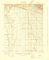 1929 Fairfax School1929 Print · USGSSoutheastern Bakersfield and the surrounding Kern County ranch lands are captured here in the late twenties, during a period of significant agricultural growth. Genealogists and local historians can trace rural school districts like Fairfax Sch and Mountain View Sch alongside the essential Kern Island Canal system.
 - 1929 Map of Coles Levee
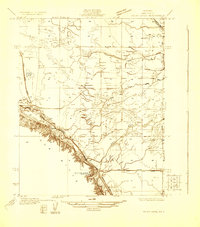 1929 Coles Levee1929 Print · USGSKern County in the late twenties shows a landscape defined by water engineering and early transport. You can trace the Southern Pacific RR and find sites like the Mesquite Hunting Club and the Western Water Co Pumping Plant.
End of results
Showing maps 1-3 of 3
Top cities near Bakersfield
Top neighborhoods of Bakersfield
- Quailwood historical maps
- Kern historical maps
- Wible Orchard historical maps
- Kern City historical maps
- The Polo Greens historical maps
Frequently asked questions
- What are the different types of historical maps available for Bakersfield?
- What is the oldest map of Bakersfield?
- Where can I purchase historical maps of Bakersfield for my home or office?
- Where can I download high-res historical maps of Bakersfield?
- Are there historical topographic maps available for Bakersfield?
- Is there historical aerial imagery available for Bakersfield?
- Where are historical maps of Bakersfield sourced from?