1970s Maps of Bakersfield, California
Explore 5 historic maps of Bakersfield from the 1970s. These maps offer a rare glimpse into what life looked like during the 1970s — showing old roads, neighborhoods, homes, and landmarks that have changed or disappeared over time.
Whether you're researching your family's past, planning a metal detecting trip, or studying how Bakersfield's landscape evolved across the 1970s, these high-resolution maps are a powerful tool for exploring the history of this region.
- Focus on a specific era: All maps on this page are from the 1970s, giving you a focused view of this time period.
- See what’s changed: Compare century-old streets, trails, and buildings to today's modern landscape using overlays and satellite layers.
- Research with precision: Use these maps for genealogy, historical research, land use analysis, or educational projects.
- View, download, or print: Maps are fully viewable online in high resolution, and can be downloaded or printed for your own records.
Start exploring Bakersfield's history through authentic maps from the 1970s. This is your window into the past.
Bakersfield, CA maps
(5)- 1978 Map of Oil Center, 1981 Print
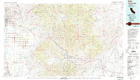
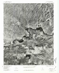 1978 Oil Center1981 Print · USGSThe northern reaches of the Central Valley meet industrial oil fields in the late seventies. Researchers can trace the growing suburban grid of Bakersfield and the winding course of the Kern River past Oil Center.
 - 1978 Map of Oildale, 1981 Print
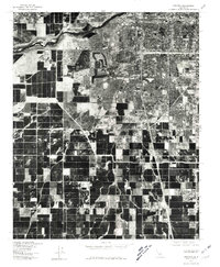
 1978 Oildale1981 Print · USGSKern County's industrial and agricultural heartland is captured here in the late seventies. Researchers can trace the layout of residential areas in Oildale and Bakersfield or study the land use patterns near Saco and Fruitvale.
 - 1978 Map of Gosford, 1981 Print
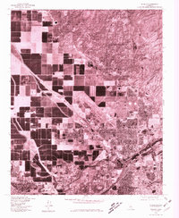
 1978 Gosford1981 Print · USGSKern County in the late seventies reveals a landscape at the crossroads of suburban expansion and industrial agriculture. Genealogists and local historians can trace the development of Kern City or locate the rural hubs of Pumpkin Center and Old River.
 - 1978 Map of Lamont, 1981 Print
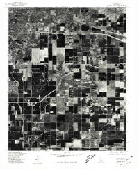 1978 Lamont1981 Print · USGSIn the late seventies, the San Joaquin Valley floor south of Bakersfield was a landscape defined by intensive agriculture and burgeoning industrial rail hubs. Genealogists and local historians can trace the development of Lamont, Fuller Acres, and the rail-side settlement of Magunden.
 - 1978 Map of Tehachapi, 1993 Print
 1978 Tehachapi1993 Print · USGSThe Kern County landscape in the late seventies reveals the transition from valley agriculture to high mountain passes. Trace the rail lines of the Southern Pacific and explore early settlements like Weed Patch, Loraine, and Edmundson Acres.
End of results
Showing maps 1-5 of 5
Top cities near Bakersfield
Top neighborhoods of Bakersfield
- Quailwood historical maps
- Kern historical maps
- Wible Orchard historical maps
- Kern City historical maps
- The Polo Greens historical maps
Frequently asked questions
- What are the different types of historical maps available for Bakersfield?
- What is the oldest map of Bakersfield?
- Where can I purchase historical maps of Bakersfield for my home or office?
- Where can I download high-res historical maps of Bakersfield?
- Are there historical topographic maps available for Bakersfield?
- Is there historical aerial imagery available for Bakersfield?
- Where are historical maps of Bakersfield sourced from?