1990s Maps of Bakersfield, California
Explore 4 historic maps of Bakersfield from the 1990s. These maps offer a rare glimpse into what life looked like during the 1990s — showing old roads, neighborhoods, homes, and landmarks that have changed or disappeared over time.
Whether you're researching your family's past, planning a metal detecting trip, or studying how Bakersfield's landscape evolved across the 1990s, these high-resolution maps are a powerful tool for exploring the history of this region.
- Focus on a specific era: All maps on this page are from the 1990s, giving you a focused view of this time period.
- See what’s changed: Compare century-old streets, trails, and buildings to today's modern landscape using overlays and satellite layers.
- Research with precision: Use these maps for genealogy, historical research, land use analysis, or educational projects.
- View, download, or print: Maps are fully viewable online in high resolution, and can be downloaded or printed for your own records.
Start exploring Bakersfield's history through authentic maps from the 1990s. This is your window into the past.
Bakersfield, CA maps
(4)- 1992 Map of Rio Bravo Ranch, 1995 Print
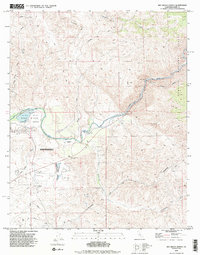 1992 Rio Bravo Ranch1995 Print · USGSNortheast of Bakersfield in the early nineties, this area showcases the intersection of the Kern River economy and foothill ranching. Researchers can trace the development of Lake Ming, the industrial footprint of the local Oil Field, and landmarks like the Father Garces Monument.2 unique versions available
 - 1992 Map of Lamont, 1995 Print
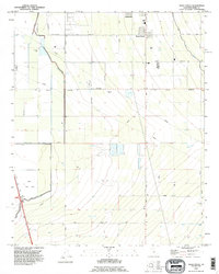
 1992 Lamont1995 Print · USGSThe outskirts of Bakersfield and the surrounding San Joaquin Valley are captured here in the early nineties, showing a landscape defined by petroleum and irrigation. Researchers can trace the industrial footprints of Fuller Acres, the Union Cemetery, and the Kern Island Canal.
 - 1992 Map of Oil Center, 1995 Print
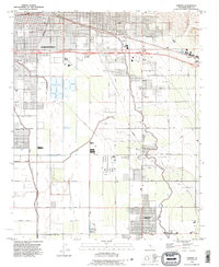
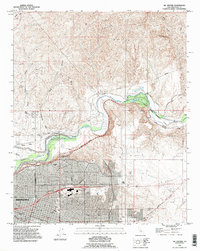 1992 Oil Center1995 Print · USGSBakersfield and the Kern River oil fields are shown in detail during the early nineties, balancing industrial production with residential growth. Researchers can trace historic river crossings at Gordons Ferry or locate landmarks like Bakersfield College and Oil City.
 - 1992 Map of Weed Patch, 1995 Print
 1992 Weed Patch1995 Print · USGSThe southern San Joaquin Valley comes into focus in the early nineties, showing the vital irrigation networks around Weed Patch and Lamont. Researchers can trace the path of the East Side Canal and locate landmarks like the Kern Lake Bed and the Airway Beacon.2 unique versions available
End of results
Showing maps 1-4 of 4
Top cities near Bakersfield
Top neighborhoods of Bakersfield
- Quailwood historical maps
- Kern historical maps
- Wible Orchard historical maps
- Kern City historical maps
- The Polo Greens historical maps
Frequently asked questions
- What are the different types of historical maps available for Bakersfield?
- What is the oldest map of Bakersfield?
- Where can I purchase historical maps of Bakersfield for my home or office?
- Where can I download high-res historical maps of Bakersfield?
- Are there historical topographic maps available for Bakersfield?
- Is there historical aerial imagery available for Bakersfield?
- Where are historical maps of Bakersfield sourced from?