1950s Maps of Bakersfield, California
Explore 16 historic maps of Bakersfield from the 1950s. These maps offer a rare glimpse into what life looked like during the 1950s — showing old roads, neighborhoods, homes, and landmarks that have changed or disappeared over time.
Whether you're researching your family's past, planning a metal detecting trip, or studying how Bakersfield's landscape evolved across the 1950s, these high-resolution maps are a powerful tool for exploring the history of this region.
- Focus on a specific era: All maps on this page are from the 1950s, giving you a focused view of this time period.
- See what’s changed: Compare century-old streets, trails, and buildings to today's modern landscape using overlays and satellite layers.
- Research with precision: Use these maps for genealogy, historical research, land use analysis, or educational projects.
- View, download, or print: Maps are fully viewable online in high resolution, and can be downloaded or printed for your own records.
Start exploring Bakersfield's history through authentic maps from the 1950s. This is your window into the past.
Bakersfield, CA maps
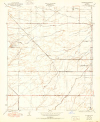
(16)- 1950 Map of Gosford
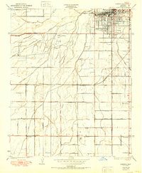 1950 Gosford1950 Print · USGSSouthwest Bakersfield and the surrounding Kern County ranch lands are caught in a moment of post-war expansion. Local researchers can trace the historic irrigation network of the Stine Canal and find old rural schools like Union Ave Sch and Fairview Sch.
 - 1950 Map of Rosedale
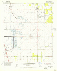
 1950 Rosedale1950 Print · USGSThe Rosedale area of Kern County is shown during a period of significant agricultural expansion and rail development. Researchers can trace early irrigation networks like the Calloway Canal and locate vanished local landmarks such as Una Siding and Palm Sch.
 - 1950 Map of Fairfax School
 1950 Fairfax School1950 Print · USGSThe outskirts of Bakersfield and the surrounding Kern County farmland are captured here at the start of the 1950s. Genealogists and local historians can trace irrigation networks like the Weed Patch Canal and locate rural landmarks such as Fairfax School and the rail hub at Magunden.
 - 1950 Map of Oil Center
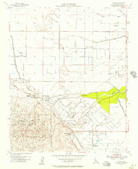
 1950 Oil Center1950 Print · USGSBakersfield and the Kern County oil fields are caught here at a height of industrial activity in the mid-twentieth century. Researchers can trace the layout of early energy settlements like Oil Center and Oil City or locate local landmarks including Aztec Sch and the County Hospital.
 - 1950 Map of Stevens
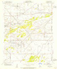
 1950 Stevens1950 Print · USGSMid-century Kern County is defined here by its complex irrigation networks and oil infrastructure just as the valley's agricultural character was fully maturing. Researchers can trace the Southern Pacific rail line through Stevens or locate landmarks like the Rio Bravo Oil Pumping Sta and Munzer Sch.
 - 1954 Map of Rosedale, 1955 Print
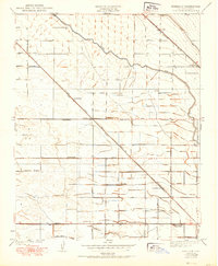
 1954 Rosedale1955 Print · USGSKern County's oil and agricultural heartland is captured here in the mid-1950s during a period of industrial intensification. Researchers can trace the development of the Rosedale Oil Field alongside local landmarks like Shafter Cemetery and Greeley Sch.3 unique versions available
 - 1954 Map of Rio Bravo Ranch, 1955 Print
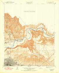
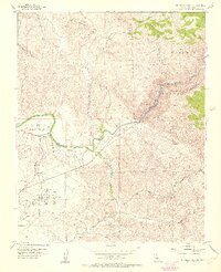 1954 Rio Bravo Ranch1955 Print · USGSThe Kern River foothills come alive in the mid-1950s, showing a landscape defined by water power and oil extraction. Trace early energy infrastructure like the Ant Hill Oil Field and the Powerhouse system, or locate the Father Garces Monument.4 unique versions available
 - 1954 Map of Lamont, 1955 Print
 1954 Lamont1955 Print · USGSSoutheast of Bakersfield in the mid-fifties, this area reveals a landscape deeply shaped by petroleum and irrigation. Genealogists and historians can trace early neighborhood schools like Virginia Sch and Edison Sch or locate the industrial centers of Lamont and the Mountain View Oil Field.3 unique versions available
 - 1954 Map of Stevens, 1955 Print
 1954 Stevens1955 Print · USGSMid-century Kern County is defined here by its massive petroleum infrastructure and the industrial corridors of the San Joaquin Valley. Researchers can trace the legacy of the Ten Section Oil Field, find the Buena Vista Sch, and locate the Ten Section Refinery near Stevens.4 unique versions available
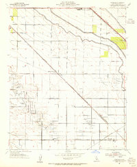
 - 1954 Map of Gosford, 1955 Print
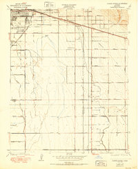
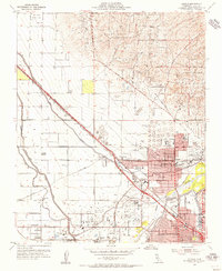
 1954 Gosford1955 Print · USGSBakersfield and its southern rural outskirts are captured in the mid-1950s as suburban growth began to meet the valley's oil and agricultural heartland. Researchers can trace the development of small communities like Pumpkin Center and Old River or locate local landmarks such as the County Fairgrounds and the Fruitvale Oil Field.3 unique versions available
 - 1954 Map of Oildale, 1956 Print
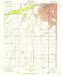
 1954 Oildale1956 Print · USGSIn the mid-1950s, the landscape north of Bakersfield was a hive of industrial activity driven by the petroleum and rail sectors. Genealogists and local historians can trace the growth of Oildale and Fruitvale, finding specific landmarks like Norris School, Oil Junction, and the Kern River Oil Field.4 unique versions available
 - 1954 Map of Oil Center, 1956 Print
 1954 Oil Center1956 Print · USGSBakersfield and its surrounding petroleum districts are shown in high detail during the mid-1950s, as the oil industry reshaped the Kern County landscape. Genealogists and local historians can locate early industrial sites like Oil Center, the Gordons Ferry site, and numerous local schools such as Aztec Sch.4 unique versions available
 - 1954 Map of Tupman, 1957 Print
 1954 Tupman1957 Print · USGSKern County’s industrial and natural borders met in the 1950s where petroleum reserves and wildlife refuges lined the valley floor. Researchers can trace the layout of the North Coles Levee Oil Field and find community landmarks like the Elk Hills School and Tupman.3 unique versions available
 - 1955 Map of Bakersfield
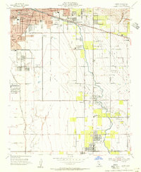
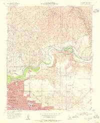
 1955 Bakersfield1955 Print · USGSThe southern San Joaquin Valley in the mid-fifties shows an era of massive oil production and industrial irrigation. Trace family roots in Allensworth, the oil fields of Oildale, or the shorelines of Tulare Lake and Buena Vista Lake.
 - 1955 Map of Weed Patch, 1956 Print
 1955 Weed Patch1956 Print · USGSThe agricultural heart of Kern County comes alive in the mid-1950s, showing a landscape defined by irrigation and labor centers. Genealogists and local historians can trace the Arvin Farm Labor Supply Center, family ranching at Greenfield Ranch, and numerous unique sites like the Dust Bowl Duck Club.3 unique versions available
 - 1956 Map of Bakersfield
 1956 Bakersfield1956 Print · USGSThe southern San Joaquin Valley and High Sierra come alive in the mid-fifties, showing the region's complex agricultural and rail networks. Genealogists and historians can trace family roots in towns like Bakersfield, Taft, and Delano, or locate early infrastructure along the Sunset Railway.
End of results
Showing maps 1-16 of 16
Top cities near Bakersfield
Top neighborhoods of Bakersfield
- Quailwood historical maps
- Kern historical maps
- Wible Orchard historical maps
- Kern City historical maps
- The Polo Greens historical maps
Frequently asked questions
- What are the different types of historical maps available for Bakersfield?
- What is the oldest map of Bakersfield?
- Where can I purchase historical maps of Bakersfield for my home or office?
- Where can I download high-res historical maps of Bakersfield?
- Are there historical topographic maps available for Bakersfield?
- Is there historical aerial imagery available for Bakersfield?
- Where are historical maps of Bakersfield sourced from?