1980s Maps of Los Angeles County, California
Explore 8 historic maps of Los Angeles County from the 1980s. These maps offer a rare glimpse into what life looked like during the 1980s — showing old roads, neighborhoods, homes, and landmarks that have changed or disappeared over time.
Whether you're researching your family's past, planning a metal detecting trip, or studying how Los Angeles County's landscape evolved across the 1980s, these high-resolution maps are a powerful tool for exploring the history of this region.
- Focus on a specific era: All maps on this page are from the 1980s, giving you a focused view of this time period.
- See what’s changed: Compare century-old streets, trails, and buildings to today's modern landscape using overlays and satellite layers.
- Research with precision: Use these maps for genealogy, historical research, land use analysis, or educational projects.
- View, download, or print: Maps are fully viewable online in high resolution, and can be downloaded or printed for your own records.
Start exploring Los Angeles County's history through authentic maps from the 1980s. This is your window into the past.
Los Angeles County, CA maps
(8)- 1980 Map of San Clemente Island
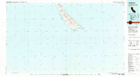 1980 San Clemente Island1980 Print · USGSSan Clemente Island in the early eighties serves as a critical naval outpost off the California coast. Researchers can trace military infrastructure like the Landing Strip and the Naval Ocean Systems Center Island Facility alongside landmarks like Pyramid Head and Seal Cove.2 unique versions available
 - 1981 Map of Santa Catalina Island
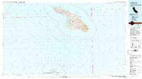 1981 Santa Catalina Island1981 Print · USGSSanta Catalina and San Clemente islands are shown in the early eighties, detailing the rugged interior peaks and isolated coastal coves of Los Angeles County. Trace the geographic layout of Avalon, the air connections at the Landing Field, and military installations at the Naval Ocean Systems Center.2 unique versions available
 - 1981 Map of Long Beach
 1981 Long Beach1981 Print · USGSCoastal Los Angeles and the South Bay reached a peak of industrial and suburban maturity in the early eighties. Researchers can trace the development of aerospace and maritime hubs through landmarks like the Queen Mary, Fort MacArthur, and Signal Hill.3 unique versions available
 - 1981 Map of Yorba Linda, 1982 Print
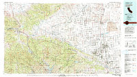
 1981 Yorba Linda1982 Print · USGSOrange County's northern hills underwent a rapid transition from petroleum production to suburban expansion in the early eighties. Genealogists and local historians can trace specific residential growth around Richard M Nixon Sch and the Brea-Olinda Oil Field.
 - 1981 Map of Lancaster, 1984 Print
 1981 Lancaster1984 Print · USGSThe high desert and mountain passes of northern Los Angeles County come alive in this early eighties survey. Researchers can trace the San Andreas Rift Zone past remote outposts like Gorman or locate the historic Golden Queen Mine near the Mojave edge.2 unique versions available
 - 1982 Map of Victorville
 1982 Victorville1982 Print · USGSThe High Desert during the early eighties reveals a landscape of massive aerospace installations and growing desert communities. Researchers can trace the sprawling boundaries of Edwards Air Force Base alongside the vital California Aqueduct and the rail hub at Barstow.2 unique versions available
 - 1982 Map of San Bernardino, 1983 Print
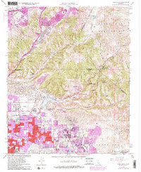
 1982 San Bernardino1983 Print · USGSThe Inland Empire and San Gabriel Valley met at a peak of suburban and industrial expansion in the early eighties. Researchers can trace the massive rail infrastructure through Cajon Pass and locate landmarks like Norton Air Force Base or the Fontana International Raceway.
 - 1983 Map of Santa Ana
 1983 Santa Ana1983 Print · USGSCoastal Orange County meets the Inland Empire in the early eighties as suburban growth accelerates through the SANTA ANA MOUNTAINS. Researchers can trace institutional and military history at MARCH AIR FORCE BASE, locate the Santiago Coal Mine, or find family sites near Fairhaven Cem.
End of results
Showing maps 1-8 of 8
Top cities of Los Angeles County
- Los Angeles historical maps
- Long Beach historical maps
- Glendale historical maps
- Santa Clarita historical maps
- Pomona historical maps
- Palmdale historical maps
See more
Frequently asked questions
- What are the different types of historical maps available for Los Angeles County?
- What is the oldest map of Los Angeles County?
- Where can I purchase historical maps of Los Angeles County for my home or office?
- Where can I download high-res historical maps of Los Angeles County?
- Are there historical topographic maps available for Los Angeles County?
- Is there historical aerial imagery available for Los Angeles County?
- Where are historical maps of Los Angeles County sourced from?