1930s Maps of Monterey County, California
Explore 8 historic maps of Monterey County from the 1930s. These maps offer a rare glimpse into what life looked like during the 1930s — showing old roads, neighborhoods, homes, and landmarks that have changed or disappeared over time.
Whether you're researching your family's past, planning a metal detecting trip, or studying how Monterey County's landscape evolved across the 1930s, these high-resolution maps are a powerful tool for exploring the history of this region.
- Focus on a specific era: All maps on this page are from the 1930s, giving you a focused view of this time period.
- See what’s changed: Compare century-old streets, trails, and buildings to today's modern landscape using overlays and satellite layers.
- Research with precision: Use these maps for genealogy, historical research, land use analysis, or educational projects.
- View, download, or print: Maps are fully viewable online in high resolution, and can be downloaded or printed for your own records.
Start exploring Monterey County's history through authentic maps from the 1930s. This is your window into the past.
Monterey County, CA maps
(8)- 1931 Map of San Benito
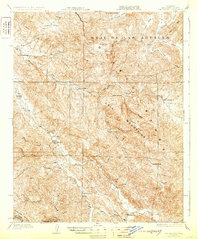 1931 San Benito1931 Print · USGSThe high ridges and deep river canyons of San Benito County are captured here in the early twentieth century. Genealogists and local historians can trace the remote Los Muertos Ranch, early rural schoolhouses like Emmett School, and the northern reaches of Pinnacles Nat Mon.2 unique versions available
 - 1934 Map of The Dark Hole
 1934 The Dark Hole1934 Print · USGSThe Fresno and Monterey county lines meet in this 1930s survey of the rugged interior Coast Ranges. Genealogists can trace family outposts like Radcliff Cabin and Moore Cabin alongside the King Mine and the distinctive Dark Hole.
 - 1934 Map of Reef Ridge
 1934 Reef Ridge1934 Print · USGSThe Fresno and Kings County line ran through a landscape of ranching and early oil work in the 1930s. Genealogists and historians can trace family-named sites like the Ernest Kreyenhagen Ranch or the Vones Ranch Adobe Ruins.
 - 1937 Map of Reef Ridge
 1937 Reef Ridge1937 Print · USGSKings and Monterey counties were defined by isolated ranching and early oil infrastructure in the mid-1930s. Researchers can trace family history at the Ernest Kreyenhagen Ranch or locate industrial sites like the Avenal Canyon Mine and the Union Oil Co Pumping Sta.2 unique versions available
 - 1937 Map of The Dark Hole
 1937 The Dark Hole1937 Print · USGSThe rugged junction of Fresno, Monterey, and Kings Counties is captured here in the mid-1930s. Genealogists and historians can trace isolated homesteads like Moore Cabin and Carollo Cabin, or locate the remote Kings Mine and Pinosa House (Ruins).2 unique versions available
 - 1939 Map of King City
 1939 King City1939 Print · USGSThe Salinas Valley and surrounding Santa Lucia Range come alive in the late 1930s as a landscape of cattle ranchos and military growth. Genealogists can trace family landmarks like Sweetwater School or locate the San Antonio Mission within the Hunter Liggett Military Reservation.
 - 1939 Map of Jamesburg, 1956 Print
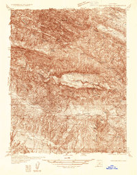
 1939 Jamesburg1956 Print · USGSJamesburg and the surrounding Santa Lucia Range appear here just before the mid-century, capturing the era of mountain ranching and early dam construction. Researchers can locate the Tularcitos Sch, the early San Clemente Dam, and family landmarks like Bruce Ranch.2 unique versions available
 - 1939 Map of San Juan Bautista, 1958 Print
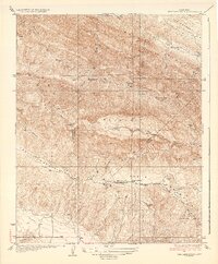
 1939 San Juan Bautista1958 Print · USGSThe Central Coast landscape at the dawn of World War II is documented here, showing the intersection of Spanish-era ranchos and the Southern Pacific rail line. Researchers can trace the grounds of Mission San Juan Bautista, identify the Sargent Oil Field, and locate numerous rural schoolhouses like Carlton School.
End of results
Showing maps 1-8 of 8
Top cities of Monterey County
- Salinas historical maps
- Monterey historical maps
- Marina historical maps
- Prunedale historical maps
- Pacific Grove historical maps
- Greenfield historical maps
See more
Frequently asked questions
- What are the different types of historical maps available for Monterey County?
- What is the oldest map of Monterey County?
- Where can I purchase historical maps of Monterey County for my home or office?
- Where can I download high-res historical maps of Monterey County?
- Are there historical topographic maps available for Monterey County?
- Is there historical aerial imagery available for Monterey County?
- Where are historical maps of Monterey County sourced from?