1950s Maps of Plumas County, California
Explore 36 historic maps of Plumas County from the 1950s. These maps offer a rare glimpse into what life looked like during the 1950s — showing old roads, neighborhoods, homes, and landmarks that have changed or disappeared over time.
Whether you're researching your family's past, planning a metal detecting trip, or studying how Plumas County's landscape evolved across the 1950s, these high-resolution maps are a powerful tool for exploring the history of this region.
- Focus on a specific era: All maps on this page are from the 1950s, giving you a focused view of this time period.
- See what’s changed: Compare century-old streets, trails, and buildings to today's modern landscape using overlays and satellite layers.
- Research with precision: Use these maps for genealogy, historical research, land use analysis, or educational projects.
- View, download, or print: Maps are fully viewable online in high resolution, and can be downloaded or printed for your own records.
Start exploring Plumas County's history through authentic maps from the 1950s. This is your window into the past.
Plumas County, CA maps
(36)- 1950 Map of Strawberry Valley
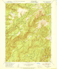
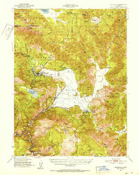
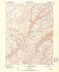
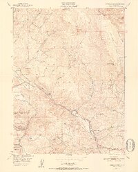
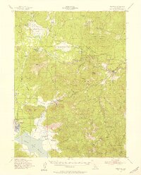
 1950 Strawberry Valley1950 Print · USGSThe Gold Country of the northern Sierras comes into focus at mid-century, showing the overlapping boundaries of Plumas and Tahoe National Forests. Genealogists and researchers can trace historical mining sites and river bars like Brandy City, Strawberry Valley, and the Palace Mine.
 - 1950 Map of Cascade
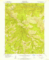
 1950 Cascade1950 Print · USGSThe mid-century Sierra Nevada foothills come alive in this survey of the Butte and Plumas county line. Researchers can trace historic mountain homesteads and industrial relics like the Walters Mine, the LOGGING RR at Camp Eighteen, and family sites like Graves Cabin.
 - 1950 Map of American House
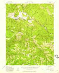
 1950 American House1950 Print · USGSThe Plumas National Forest backcountry is documented here during the post-war era, showing a landscape defined by timber, water, and early mining. Trace local history through sites like American House, the Lexington Hill Lookout, and the Sanborn Mine.2 unique versions available
 - 1950 Map of Chilcoot, 1952 Print
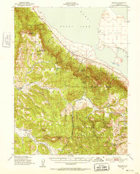
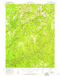
 1950 Chilcoot1952 Print · USGSThe high Sierra gateway at Beckwourth Pass is documented here at mid-century as the railroad and highway networks expanded. Researchers can trace the routes of the Western Pacific and locate local landmarks like Summit Sch and Hallelujah Junction.5 unique versions available
 - 1950 Map of Kettle Rock, 1952 Print
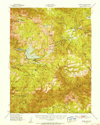
 1950 Kettle Rock1952 Print · USGSThe Plumas National Forest and Diamond Mountains are captured here at the start of the 1950s during a peak era for timber and mining. Researchers can trace the Logging Railroad to Clover Valley Lumber Camp No 14 or locate the remote Engel Mine Upper Camp and Beardsley Mine.3 unique versions available
 - 1950 Map of Portola, 1952 Print
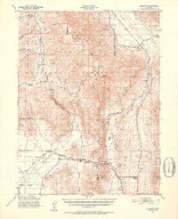
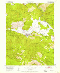
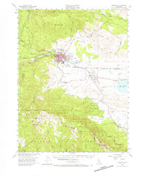
 1950 Portola1952 Print · USGSPortola and the Sierra Valley are captured here in the early 1950s as the rail and timber industries shaped the Plumas County landscape. Researchers can trace the Western Pacific Railroad corridor, locate the Island Sch (Aband), and find family landmarks like Ramelli Ranch.4 unique versions available
 - 1950 Map of Greenville, 1952 Print
 1950 Greenville1952 Print · USGSPlumas County at the mid-century shows a landscape shaped by the Western Pacific RR and deep-vein mining operations. Local researchers can trace the footings of the Engel Mine, the Indian Mission, and historical settlements like Crescent Mills and Taylorsville.4 unique versions available
 - 1950 Map of Milford, 1952 Print
 1950 Milford1952 Print · USGSThe high desert basin meets the timbered peaks of the Sierras in the early fifties. Genealogists and historians can trace family-named sites like Clark Ranch, the early operations of the Honey Lake Mine, and the mid-century boundaries of the Dixie Mountain State Game Refuge.3 unique versions available
 - 1950 Map of Bucks Lake, 1953 Print
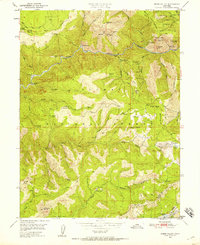
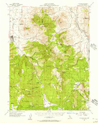
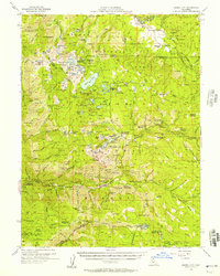
 1950 Bucks Lake1953 Print · USGSThe High Sierra timberlands and alpine lakes of Plumas County are captured here just after the mid-century. Researchers can trace early ranching and mining sites like Spanish Ranch, the Pineleaf Mine, and the U C Forestry Camp in Meadow Valley.3 unique versions available
 - 1950 Map of Spring Garden, 1958 Print
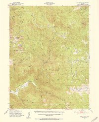
 1950 Spring Garden1958 Print · USGSThe northern Sierra Nevada's rail and timber landscape comes into focus mid-century as the Plumas National Forest undergoes modernization. Trace the Western Pacific route past the Johnson Mine (Abandoned) and the small settlements of Massack and Spring Garden.2 unique versions available
 - 1950 Map of Quincy, 1958 Print
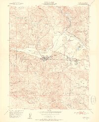
 1950 Quincy1958 Print · USGSAmerican Valley in the mid-twentieth century was a vital hub for Plumas County logging and transport. Genealogists and researchers can trace the old footprints of Newtown, locate the Indian Cemetery, and follow the Western Pacific Railroad through Quincy.5 unique versions available
 - 1950 Map of Onion Valley, 1958 Print
 1950 Onion Valley1958 Print · USGSPlumas County is captured here in the mid-twentieth century, showcasing a landscape shaped by the Feather River and a deep mining history. Genealogists and researchers can trace former settlements at Onion Valley or locate old operations like the Five Bear Mine and Rich Bar.3 unique versions available
 - 1951 Map of Onion Valley
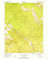
 1951 Onion Valley1951 Print · USGSThe northern Sierra Nevada highlands appear in the early fifties as a landscape of recovering forest and dormant gold works. Trace the history of the Feather River canyon through mining claims like the Belfrin Mine and vanished outposts at McCarthy Bar and Last Chance (Site).
 - 1951 Map of Quincy
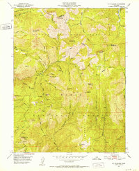
 1951 Quincy1951 Print · USGSQuincy and the American Valley are seen here in the early fifties during a period of steady timber and rail activity. Genealogists and historians can locate the Indian Cemetery, trace the Western Pacific Railroad, and find early sites like the Imperial Mine or Pioneer Sch.2 unique versions available
 - 1951 Map of Mt. Fillmore, 1952 Print
 1951 Mt. Fillmore1952 Print · USGSSierra County gold country is frozen in time during the early 1950s, documenting the remote canyons and high ridges between the Yuba and Downie Rivers. Researchers can trace the heritage of the northern mines through landmarks like Poker Flat, the California Mine, and the Deadwood Diggings.3 unique versions available
 - 1951 Map of La Porte, 1952 Print
 1951 La Porte1952 Print · USGSGold Rush-era mining camps and high-country forests define this landscape in the early fifties. Local historians can trace family roots at Pine Grove Cem or locate the former sites of Gibsonville, Port Wine, and the Thistle Shaft (Site).4 unique versions available
 - 1951 Map of Blue Nose Mtn, 1953 Print
 1951 Blue Nose Mtn1953 Print · USGSPlumas County gold country is documented here in the early fifties, showing the high-elevation mines and river bars of the Sierra Nevada. Trace the legacy of early mining at Turkeytown Diggings, the Nelson Point (Site), and the Bunker Hill Mine.5 unique versions available
 - 1951 Map of Quincy, 1958 Print
 1951 Quincy1958 Print · USGSMid-century Plumas County comes alive through this survey of the American Valley and its surrounding gold-bearing ridges. Researchers can trace the Western Pacific Railroad past historic points like Nelson Point and the Hungarian Placer Mine.3 unique versions available
 - 1951 Map of Downieville, 1958 Print
 1951 Downieville1958 Print · USGSGold country life in the early fifties centered on the deep canyons of the Yuba and Feather Rivers. Trace the legacies of mining camps and family holdings from Downieville to the remote Howland Flat and the Standard Mine.3 unique versions available
 - 1952 Map of Spring Garden
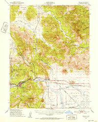
 1952 Spring Garden1952 Print · USGSThe Sierra Nevada rail corridor is defined by the remarkable Williams Loop during the early fifties. Local historians can trace the timber and mining roots of Massack and Spring Garden, or locate the Johnson Mine (Abandoned) and the Fire Station at Lee Summit.2 unique versions available
 - 1954 Map of Susanville
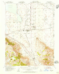
 1954 Susanville1954 Print · USGSMid-century Susanville and the surrounding Honey Lake Valley are captured here during a period of steady growth and rail reliance. Researchers can trace family ties at the Lassen Cem, locate Peter Lassens Grave, and see the early layout of the Susanville Indian Rancheria.3 unique versions available
 - 1954 Map of Doyle, 1956 Print
 1954 Doyle1956 Print · USGSLassen County's high-desert landscape and military infrastructure are detailed here in the mid-fifties. Genealogists and historians can trace the development of Herlong and the Sierra Ordnance Depot alongside rural landmarks like Bird Flat Sch and the Honey Lake Cemetery.3 unique versions available
 - 1955 Map of Loyalton, 1957 Print
 1955 Loyalton1957 Print · USGSThe Sierra Valley and the high timberlands of the California-Nevada border come alive in the mid-fifties. Genealogists can trace the Loyalton Cem and isolated outposts like Balls Ranch or the Flying Dutchman Mine.4 unique versions available
 - 1955 Map of Westwood, 1957 Print
 1955 Westwood1957 Print · USGSThe timber and ranching culture of the Lassen highlands is captured here during the mid-fifties. Genealogists and historians can trace family properties like Worley Ranch and Stephens Ranch or follow the rails to Westwood Junction.3 unique versions available
 - 1955 Map of Sierra City, 1957 Print
 1955 Sierra City1957 Print · USGSSierra County and the surrounding high country are captured here during the mid-1950s as the era of hard-rock mining transitioned into a seasonal recreation economy. Genealogists and historians can trace family-named sites like Fournier Ranch and McKenzie Ranch, or locate numerous mining operations including the Empire Mine and Loganville.5 unique versions available
Showing maps 1-25 of 36
Top cities of Plumas County
- Portola historical maps
- Chester historical maps
- Hamilton Branch historical maps
- Chilcoot–Venton historical maps
Frequently asked questions
- What are the different types of historical maps available for Plumas County?
- What is the oldest map of Plumas County?
- Where can I purchase historical maps of Plumas County for my home or office?
- Where can I download high-res historical maps of Plumas County?
- Are there historical topographic maps available for Plumas County?
- Is there historical aerial imagery available for Plumas County?
- Where are historical maps of Plumas County sourced from?