1890s Maps of Plumas County, California
Explore 16 historic maps of Plumas County from the 1890s. These maps offer a rare glimpse into what life looked like during the 1890s — showing old roads, neighborhoods, homes, and landmarks that have changed or disappeared over time.
Whether you're researching your family's past, planning a metal detecting trip, or studying how Plumas County's landscape evolved across the 1890s, these high-resolution maps are a powerful tool for exploring the history of this region.
- Focus on a specific era: All maps on this page are from the 1890s, giving you a focused view of this time period.
- See what’s changed: Compare century-old streets, trails, and buildings to today's modern landscape using overlays and satellite layers.
- Research with precision: Use these maps for genealogy, historical research, land use analysis, or educational projects.
- View, download, or print: Maps are fully viewable online in high resolution, and can be downloaded or printed for your own records.
Start exploring Plumas County's history through authentic maps from the 1890s. This is your window into the past.
Plumas County, CA maps
(16)- 1890 Map of Sierraville, 1955 Print
 1890 Sierraville1955 Print · USGSThe high Sierra Valley and its frontier timber towns are captured here in the late 1800s. Genealogists and historians can trace early rail lines like the Nevada California and Oregon Railway and locate vanished stops and landmarks such as Etta, Purdy, and the Sulphur Spring.
 - 1891 Map of Bidwell Bar
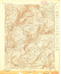
 1891 Bidwell Bar1891 Print · USGSThe gold-country ridges and deep river canyons of the northern Sierras are shown in the late nineteenth century as mining and timber production shaped the land. Researchers can trace early family-named waystations and industrial sites like American House, Bidwell Bar, and Clipper Mill.
 - 1891 Map of Downieville
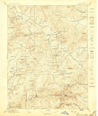
 1891 Downieville1891 Print · USGSThe gold-bearing ridges of the Northern Sierra come alive in the 1890s, when mining camps and high-country ranches defined the local economy. Researchers can trace the Sierra Turnpike and locate historic claims like the Empire Mine or the settlement of Whiskey Diggings.
 - 1891 Map of Honey Lake
 1891 Honey Lake1891 Print · USGSLassen and Plumas counties appear here in the early 1890s, when the region's cattle ranches and mountain towns were first being systematically mapped. Genealogists and local historians can trace early residents through family-named sites like Halls, Buntingville, and Stocktons.
 - 1892 Map of Sierraville
 1892 Sierraville1892 Print · USGSSierraville and the high meadows of the eastern Sierras are shown here in the early 1890s, just as the regional rail network was expanding. Genealogists can trace early homesteads and communities like Loyalton, Sattley, and Beckwith, or follow the California Nevada and Oregon Railway as it winds toward the state line.
 - 1892 Map of Lassen Peak
 1892 Lassen Peak1892 Print · USGSThe volcanic highlands of the southern Cascades are captured in the late nineteenth century, showing early milling and mountain settlements. Genealogists and historians can trace pioneer sites like Prattville, the old Eureka Mill, and the crossings at Caribou Bridge.
 - 1893 Map of Bidwell Bar
 1893 Bidwell Bar1893 Print · USGSThe Plumas mountains during the late nineteenth century show a landscape defined by gold-era mining and remote stage stops. Genealogists and historians can locate early homesteads and industrial sites like Snows Mine, American House, and Bidwell Bar.
 - 1893 Map of Honey Lake
 1893 Honey Lake1893 Print · USGSNortheastern California at the close of the 19th century was a landscape of terminal lakes and early valley settlements. Genealogists and historians can trace family-named sites like Moultons and Stocktons, alongside regional hubs like Susanville and the lakeside town of Amedee.6 unique versions available
 - 1893 Map of Downieville
 1893 Downieville1893 Print · USGSThe northern Sierra Nevada's gold country is revealed here during its late nineteenth-century mining peak. Researchers can trace historic claims and family outposts from Whiskey Diggings and Poker Flat to the Plumas Eureka mine.
 - 1894 Map of Sierraville
 1894 Sierraville1894 Print · USGSThe high Sierra and Plumas county borderlands are shown in the late nineteenth century as early settlements began to take root in the basin. Researchers can trace the path of the California Nevada and Oregon Railway and locate historic sites like Sierraville, the Fair Grounds, and Loyalton.9 unique versions available
 - 1894 Map of Lassen Peak
 1894 Lassen Peak1894 Print · USGSThe volcanic highlands of Northern California are captured here in the 1890s, shortly after the initial topographic surveys. Genealogists and historians can locate early industry and mountain outposts like Eureka Mill, Prattville, and the remote Hat Creek Post Office.8 unique versions available
 - 1895 Map of Bidwell Bar
 1895 Bidwell Bar1895 Print · USGSThe Sierra foothills and high ridges of Northern California are captured here in the late nineteenth century. Genealogists and historians can trace isolated waystations and timber camps like American House, Spanish Ranch, and the Old Defiance Mill.
 - 1895 Map of Downieville
 1895 Downieville1895 Print · USGSThe high Sierra mining districts of the 1890s are captured here during a peak era of resource extraction. Researchers can trace historic gold camps and industrial sites like Whiskey Diggings, the Plumas Eureka mine, and Poker Flat.
 - 1896 Map of Downieville
 1896 Downieville1896 Print · USGSThe northern Sierra Nevada comes alive in this 1890s survey of the Feather and Yuba River watersheds. Genealogists and historians can trace gold-rush era settlements from Quincy to Downieville, locating historic sites like Whiskey Diggings and the Empire Mine.
 - 1897 Map of Bidwell Bar
 1897 Bidwell Bar1897 Print · USGSThe Sierra Nevada foothills and river canyons come alive in the 1890s as a landscape of remote mines and mountain ranching. Genealogists can trace early homesteads and social hubs like Spanish Ranch, Forbestown, and Old Defiance Mill.7 unique versions available
 - 1897 Map of Downieville
 1897 Downieville1897 Print · USGSThe northern Sierra Nevada's rugged gold country comes to life in the late nineteenth century, showing the dense network of camps and mines around Downieville. Researchers can trace the exact locations of historic operations like the Young America Mine and long-standing settlements like Howland Flat and Quincy.7 unique versions available
End of results
Showing maps 1-16 of 16
Top cities of Plumas County
- Portola historical maps
- Chester historical maps
- Hamilton Branch historical maps
- Chilcoot–Venton historical maps
Frequently asked questions
- What are the different types of historical maps available for Plumas County?
- What is the oldest map of Plumas County?
- Where can I purchase historical maps of Plumas County for my home or office?
- Where can I download high-res historical maps of Plumas County?
- Are there historical topographic maps available for Plumas County?
- Is there historical aerial imagery available for Plumas County?
- Where are historical maps of Plumas County sourced from?