1900s (20th Century) Maps of San Bernardino County, California
Explore 728 historic maps of San Bernardino County from the 1900s (20th Century). These maps offer a rare glimpse into what life looked like during the 1900s — showing old roads, neighborhoods, homes, and landmarks that have changed or disappeared over time.
Whether you're researching your family's past, planning a metal detecting trip, or studying how San Bernardino County's landscape evolved across the 1900s, these high-resolution maps are a powerful tool for exploring the history of this region.
- Focus on a specific era: All maps on this page are from the 1900s, giving you a focused view of this time period.
- See what’s changed: Compare century-old streets, trails, and buildings to today's modern landscape using overlays and satellite layers.
- Research with precision: Use these maps for genealogy, historical research, land use analysis, or educational projects.
- View, download, or print: Maps are fully viewable online in high resolution, and can be downloaded or printed for your own records.
Start exploring San Bernardino County's history through authentic maps from the 1900s. This is your window into the past.
San Bernardino County, CA maps
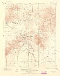
(728)- 1900 Map of Cucamonga
 1900 Cucamonga1900 Print · USGSSan Bernardino and Los Angeles Counties are shown here during the late nineteenth-century citrus boom, before urban sprawl merged these distinct agricultural colonies. Trace early rail lines through Ioamosa, Claremont, and Chino, or locate the isolated Toll House and Power House in the northern canyons.
 - 1901 Map of Southern California Sheet No. 1
 1901 Southern California Sheet No. 11901 Print · USGSGreater Los Angeles at the dawn of the twentieth century is a landscape of growing citrus towns and a burgeoning rail network. Genealogists and historians can trace the early gridded streets of Hollywood and Pasadena or locate landmarks like Bear Lake and the Cahuilla Indian Reservation.6 unique versions available
 - 1901 Map of San Bernardino
 1901 San Bernardino1901 Print · USGSThe San Bernardino valley thrived as a railway and agricultural crossroads in the late nineteenth century. Genealogists and historians can trace early citrus-belt settlements like Rialto and Colton, or locate landmarks such as Arrowhead Springs and Glen Helen Ranch.8 unique versions available
 - 1901 Map of Anaheim
 1901 Anaheim1901 Print · USGSOrange County's citrus and rail heartland is meticulously detailed at the start of the century, showing the early layouts of Anaheim and Fullerton. Genealogists can trace early homesteads and rail stops like Loara, Miraflores, and Olinda.6 unique versions available
 - 1901 Map of Redlands
 1901 Redlands1901 Print · USGSRedlands and the San Bernardino valley are seen here at the turn of the century as agriculture and rail networks began to reshape the landscape. Genealogists and historians can trace early irrigation ditches like the Zanja or locate vanished landmarks like the Asylum and Harlem Springs.9 unique versions available
 - 1902 Map of Deep Creek
 1902 Deep Creek1902 Print · USGSThe San Bernardino high country meets the desert edge at the turn of the century, showing a landscape of early ranches and timber harvesting. Genealogists and historians can trace Coxey Ranch, an early Saw Mill, and the original topography of Little Bear Valley.7 unique versions available
 - 1902 Map of Hesperia
 1902 Hesperia1902 Print · USGSSan Bernardino County at the turn of the century shows the vital rail corridor climbing toward the high desert. Genealogists and historians can trace the early route of the Southern California railroad and locate historic outposts like Burcham Ranch and Hesperia.6 unique versions available
 - 1902 Map of San Gorgonio
 1902 San Gorgonio1902 Print · USGSSouthern California at the turn of the century reveals a land of high-desert ranches and remote mountain mining camps. Genealogists and historians can locate early landmarks like Box S Ranch, Old Woman Springs, and the Rose Mine.8 unique versions available
 - 1902 Map of Corona
 1902 Corona1902 Print · USGSThe Orange County and Riverside borderlands at the start of the 1900s show an era of rapid rail expansion and water engineering. Researchers can trace the early footprints of Anaheim and Orange or find vanished industry at the Santiago Coal Mine.7 unique versions available
 - 1903 Map of Randsburg
 1903 Randsburg1903 Print · USGSThe Rand Mining District comes to life in this survey of the California desert during the early twentieth-century gold rush. Genealogists and mining historians can trace the early footprints of Randsburg and Johannesburg, the path of the Randsburg R. R., and the locations of the Yellow Aster Mine and Summit Diggings.
 - 1903 Map of Cucamonga
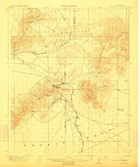
 1903 Cucamonga1903 Print · USGSThe Inland Empire is shown at a pivotal moment of agricultural expansion in the early twentieth century, when irrigation was transforming the valley. Trace the early rail networks of the Southern Pacific and the Santa Fe through citrus-growing centers like Ontario, Cucamonga, and Ioamosa.11 unique versions available
 - 1903 Map of San Antonio
 1903 San Antonio1903 Print · USGSThe high divide of the San Gabriel Mountains is captured here at the turn of the century, showing the early boundaries of the San Gabriel Timber Land Reserve. Local history enthusiasts can trace the old paths through Swartout Valley, the depths of Mine Gulch, and the descent into Lone Pine Canyon.7 unique versions available
 - 1903 Map of Needles, 1960 Print
 1903 Needles1960 Print · USGSThe Colorado River borderlands in the early 1900s centered on the critical rail crossing at Needles. Genealogists and historians can trace early railroad sidings like Khatoum and Beal or the old Parker Road through the Chemehuevi Valley.
 - 1904 Map of Needles Special
 1904 Needles Special1904 Print · USGSThe Lower Colorado River region at the start of the twentieth century was a vital corridor for western rail expansion and river navigation. Genealogists and historians can trace the rail sidings of the Atchison Topeka and Santa Fe RR and early settlements like Mellen, Franconia, and Needles.7 unique versions available
 - 1904 Map of Pomona
 1904 Pomona1904 Print · USGSThe eastern San Gabriel Valley is shown here at the turn of the century as a burgeoning network of citrus towns and vital rail lines. Genealogists can trace early homesteads and vanished stops such as Lordsburg, Alosta, and the Rowland Siding along the Southern Pacific RR.7 unique versions available
 - 1904 Map of Southern California Sheet No. 1, 1905 Print
 1904 Southern California Sheet No. 11905 Print · USGSSouthern California at the dawn of the twentieth century shows a landscape of citrus groves and coastal towns connected by rail. Genealogists and historians can trace early settlements like San Juan Capistrano, find remote sites like the Rose Mine, and study the original water systems of the Santa Ana River.2 unique versions available
 - 1910 Map of Ivanpah, 1957 Print
 1910 Ivanpah1957 Print · USGSThe Mojave high desert at the start of the twentieth century was a landscape of remote mining camps and vital railroad junctions. Trace the early industrial footprint of Vanderbilt, the Copper World Mine, and the rail stops at Nipton and Kelso.
 - 1911 Map of Parker
 1911 Parker1911 Print · USGSThe Arizona-California borderlands are captured here in the early twentieth century as the river and rail networks began to transform the desert. Researchers can trace the development of the Colorado River Indian Reservation, the rail hub at Parker, and early mining sites like the Billy Mack Mine.3 unique versions available
 - 1911 Map of Randsburg, 1958 Print
 1911 Randsburg1958 Print · USGSHigh desert mining towns in Kern and San Bernardino counties flourished during this era of peak mineral extraction. Genealogists and historians can trace the early footprints of Randsburg and Johannesburg, or locate the Yellow Aster Mine and the rail-side settlement of Atolia.2 unique versions available
 - 1912 Map of Ivanpah
 1912 Ivanpah1912 Print · USGSThe Mojave high desert at the border of California and Nevada was a bustling corridor of mining and transcontinental rail at the start of the century. Genealogists and historians can trace defunct settlements and industrial sites like the abandoned copper smelter, Good Springs, and the Old Traction Road.5 unique versions available
 - 1912 Map of Randsburg
 1912 Randsburg1912 Print · USGSThe Rand mining district comes to life in this early century survey of the Kern County desert. Trace the rail lines of the Southern Pacific and the footprint of the massive Yellow Aster Mine near Randsburg and Atolia.3 unique versions available
 - 1915 Map of Searles Lake
 1915 Searles Lake1915 Print · USGSThe Mojave Desert at the height of its early mining boom features a landscape defined by the Trona RR and the thriving gold camps of the Rand Mountains. Genealogists and historians can trace the foundations of Randsburg, the soda works at Trona, and remote outposts like Muerto Leliter PO and Garlock.6 unique versions available
 - 1926 Map of Mohave City
 1926 Mohave City1926 Print · USGSThe Colorado River borderlands in the mid-twenties reveal a landscape of mining claims and early desert ranching before the era of modern dams. Researchers can trace the Arrowhead Trail south from Searchlight and locate family landmarks like the D Hutton Ranch or the Piute mine.
 - 1928 Map of La Verne
 1928 La Verne1928 Print · USGSIn the mid-1920s, the foothill communities east of Los Angeles were emerging from their agricultural roots into structured townsites. Researchers can trace the early Pacific Electric rail lines and locate local landmarks such as Bonita High School and the Cem in La Verne.2 unique versions available
 - 1928 Map of Claremont
 1928 Claremont1928 Print · USGSEastern Los Angeles County appears here in the late twenties, during a period of rapid suburban and academic growth. Researchers can trace the early layouts of Claremont and Pomona, locating Pomona College, the Pacific Electric lines, and the Pomona Cemetery.3 unique versions available
Showing maps 1-25 of 728
Top cities of San Bernardino County
- Fontana historical maps
- Ontario historical maps
- Rancho Cucamonga historical maps
- Victorville historical maps
- Rialto historical maps
- Hesperia historical maps
See more
Frequently asked questions
- What are the different types of historical maps available for San Bernardino County?
- What is the oldest map of San Bernardino County?
- Where can I purchase historical maps of San Bernardino County for my home or office?
- Where can I download high-res historical maps of San Bernardino County?
- Are there historical topographic maps available for San Bernardino County?
- Is there historical aerial imagery available for San Bernardino County?
- Where are historical maps of San Bernardino County sourced from?