1920s Maps of San Bernardino County, California
Explore 4 historic maps of San Bernardino County from the 1920s. These maps offer a rare glimpse into what life looked like during the 1920s — showing old roads, neighborhoods, homes, and landmarks that have changed or disappeared over time.
Whether you're researching your family's past, planning a metal detecting trip, or studying how San Bernardino County's landscape evolved across the 1920s, these high-resolution maps are a powerful tool for exploring the history of this region.
- Focus on a specific era: All maps on this page are from the 1920s, giving you a focused view of this time period.
- See what’s changed: Compare century-old streets, trails, and buildings to today's modern landscape using overlays and satellite layers.
- Research with precision: Use these maps for genealogy, historical research, land use analysis, or educational projects.
- View, download, or print: Maps are fully viewable online in high resolution, and can be downloaded or printed for your own records.
Start exploring San Bernardino County's history through authentic maps from the 1920s. This is your window into the past.
San Bernardino County, CA maps
(4)- 1926 Map of Mohave City
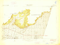
 1926 Mohave City1926 Print · USGSThe Colorado River borderlands in the mid-twenties reveal a landscape of mining claims and early desert ranching before the era of modern dams. Researchers can trace the Arrowhead Trail south from Searchlight and locate family landmarks like the D Hutton Ranch or the Piute mine.
 - 1928 Map of La Verne
 1928 La Verne1928 Print · USGSIn the mid-1920s, the foothill communities east of Los Angeles were emerging from their agricultural roots into structured townsites. Researchers can trace the early Pacific Electric rail lines and locate local landmarks such as Bonita High School and the Cem in La Verne.2 unique versions available
 - 1928 Map of Claremont
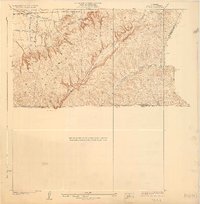
 1928 Claremont1928 Print · USGSEastern Los Angeles County appears here in the late twenties, during a period of rapid suburban and academic growth. Researchers can trace the early layouts of Claremont and Pomona, locating Pomona College, the Pacific Electric lines, and the Pomona Cemetery.3 unique versions available
 - 1928 Map of La Brea
 1928 La Brea1928 Print · USGSThe hills of Eastern Los Angeles County are captured here in the late twenties during a period of expanding ranching and early oil exploration. Genealogists and historians can trace family-named sites like Silver Peak Ranch, local landmarks such as Fairview School, and the path of the Union Pacific Railroad.3 unique versions available
End of results
Showing maps 1-4 of 4
Top cities of San Bernardino County
- Fontana historical maps
- Ontario historical maps
- Rancho Cucamonga historical maps
- Victorville historical maps
- Rialto historical maps
- Hesperia historical maps
See more
Frequently asked questions
- What are the different types of historical maps available for San Bernardino County?
- What is the oldest map of San Bernardino County?
- Where can I purchase historical maps of San Bernardino County for my home or office?
- Where can I download high-res historical maps of San Bernardino County?
- Are there historical topographic maps available for San Bernardino County?
- Is there historical aerial imagery available for San Bernardino County?
- Where are historical maps of San Bernardino County sourced from?