1950s Maps of Mesa County, Colorado
Explore 28 historic maps of Mesa County from the 1950s. These maps offer a rare glimpse into what life looked like during the 1950s — showing old roads, neighborhoods, homes, and landmarks that have changed or disappeared over time.
Whether you're researching your family's past, planning a metal detecting trip, or studying how Mesa County's landscape evolved across the 1950s, these high-resolution maps are a powerful tool for exploring the history of this region.
- Focus on a specific era: All maps on this page are from the 1950s, giving you a focused view of this time period.
- See what’s changed: Compare century-old streets, trails, and buildings to today's modern landscape using overlays and satellite layers.
- Research with precision: Use these maps for genealogy, historical research, land use analysis, or educational projects.
- View, download, or print: Maps are fully viewable online in high resolution, and can be downloaded or printed for your own records.
Start exploring Mesa County's history through authentic maps from the 1950s. This is your window into the past.
Mesa County, CO maps
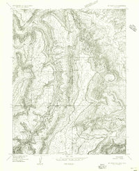
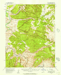
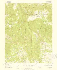
(28)- 1950 Map of Juanita Arch
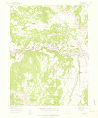
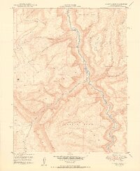 1950 Juanita Arch1950 Print · USGSMesa County is shown at the height of the uranium boom in the early fifties, where the Dolores River carves through massive mesas. Researchers can trace early mining activity at the Maverick Mines or locate the natural Juanita Arch.3 unique versions available
 - 1950 Map of Calamity Mesa
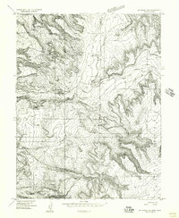
 1950 Calamity Mesa1950 Print · USGSMesa County mining operations are shown in detail during the early Cold War uranium boom. Researchers can trace the rugged access roads leading to Calamity Camp and Outlaw Camp or locate the Hidden Treasure Mine.2 unique versions available
 - 1950 Map of Pine Mountain
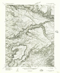
 1950 Pine Mountain1950 Print · USGSMesa County was a hub of resource mapping and forestry in the early postwar era. You can trace the steep routes of the Snowshoe Trail and Basin Trail as they navigate from Pine Mountain down into Yellowjacket Canyon.2 unique versions available
 - 1950 Map of Atkinson Creek
 1950 Atkinson Creek1950 Print · USGSThe San Miguel River valley and surrounding mesas are captured here during the mid-century mining boom. Local history researchers can trace the roads leading to the Wright Mine or locate early ranching landmarks like Spring Creek Ranch and Hog Park.2 unique versions available
 - 1950 Map of Red Canyon
 1950 Red Canyon1950 Print · USGSCanyon country at the Mesa and Montrose County line comes into focus in 1950 as postwar mineral exploration intensified. Local historians and mineral enthusiasts can locate the North Star Mine, Club Ranch, and several inactive placer mines along the Dolores River.2 unique versions available
 - 1952 Map of Gateway
 1952 Gateway1952 Print · USGSThe canyon country around the Dolores River was a center of mineral exploration in the early fifties. Researchers can locate uranium-era workings like the Vanaking No 1 Mine and trace the early routes of the Pickett Trail.2 unique versions available
 - 1954 Map of Mt Peale 1 NE
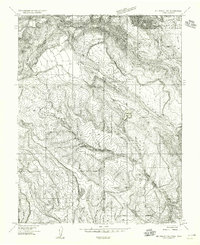 1954 Mt Peale 1 NE1954 Print · USGSThe high borderlands between Utah and Colorado come into focus in the mid-1950s, showing a remote landscape of national forest and rugged canyons. Researchers can trace early water management at Buckeye Res and locate the site of a rural Sawmill near Pine Flat.
 - 1954 Map of Mt. Waas 4 SE, 1955 Print
 1954 Mt. Waas 4 SE1955 Print · USGSThe high plateau country along the Utah-Colorado border comes into focus in the mid-1950s, showing a landscape shaped by timber and ranching. Researchers can locate remote sites like the Sawmill, Kirks Basin, and water sources at Pace Lake.
 - 1954 Map of Mt. Waas 4 NE, 1955 Print
 1954 Mt. Waas 4 NE1955 Print · USGSThe high canyons along the Utah and Colorado border are captured here in the mid-fifties, just as aerial photogrammetry was refining our view of the desert. Researchers can trace the course of the Dolores River and find evidence of early mineral exploration at a lonely Prospect or the remote Landing Field.
 - 1954 Map of Mt. Waas 1 NE, 1956 Print
 1954 Mt. Waas 1 NE1956 Print · USGSThe Utah-Colorado state line crosses this high plateau region in the mid-1950s, revealing a landscape of steep canyons and water-dependent infrastructure. Researchers can trace the path of Coach Creek, locate remote water sources like Reservoir, and follow the deep cuts of Marble Canyon.
 - 1954 Map of Mt. Waas 1 SE, 1956 Print
 1954 Mt. Waas 1 SE1956 Print · USGSThe Utah and Colorado borderlands appear in the mid-1950s as a high-altitude frontier of mesas and canyons along the Dolores River. Researchers can trace old routes like the Jeep Trail through Ryan Park or locate the remote Landing Strip near Buckskin Gulch.
 - 1954 Map of La Sal, 1957 Print
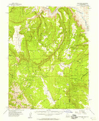
 1954 La Sal1957 Print · USGSThe La Sal Mountains at the peak of the mid-century uranium boom reveal a rugged landscape of high-altitude mining and ranching. Researchers can trace numerous prospects and operations like the Vanadium Queen Mine, Uranium Girl Mine, and the early settlement at Old La Sal.6 unique versions available
 - 1954 Map of Coates Creek, 1957 Print
 1954 Coates Creek1957 Print · USGSThe high plateau on the Utah-Colorado border is captured in the mid-1950s during a period of active mineral exploration. Researchers can trace remote ranching outposts like Picture Gallery Ranch, early mining prospects, and the distinct topography of Steamboat Mesa.3 unique versions available
 - 1954 Map of Polar Mesa, 1957 Print
 1954 Polar Mesa1957 Print · USGSThe Utah-Colorado borderlands in the mid-1950s are defined here by high plateaus and the deep canyons of the Dolores River. Researchers can trace early uranium-era infrastructure like the Landing Strip near Dolores Point and high-altitude landmarks including Mt Waas and Pace Lake.4 unique versions available
 - 1955 Map of Collbran, 1957 Print
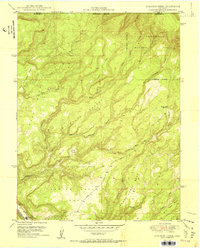
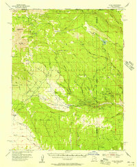
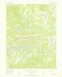
 1955 Collbran1957 Print · USGSMid-century ranching and high-country life in Mesa County are centered on the Plateau Valley and the town of Collbran. Researchers can locate family landmarks such as Cedar Crest Cem, the Pleasant View Sch, and the remote Bible and Missionary Camp.5 unique versions available
 - 1955 Map of Cameo, 1957 Print
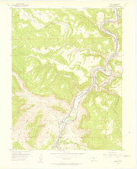 1955 Cameo1957 Print · USGSDe Beque Canyon and the Colorado River corridor are captured in the mid-fifties, showing a landscape defined by rail and irrigation engineering. Researchers can trace the Denver and Rio Grande Western tracks past the Cameo Mine and the massive Highline Canal.6 unique versions available
 - 1955 Map of Mesa, 1957 Print
 1955 Mesa1957 Print · USGSMesa and the high Plateau Valley are captured here in the mid-1950s, documenting a landscape of remote ranching and early homesteading. Genealogists can trace family landmarks like the Atwell Homestead, John Held Corner, and the Marker Tree.6 unique versions available
 - 1955 Map of Grand Mesa, 1957 Print
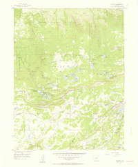
 1955 Grand Mesa1957 Print · USGSMesa County and Delta County high country in the mid-fifties was a landscape of high-altitude reservoirs and foot trails. Researchers can trace the development of mountain retreats at Grand Mesa Christian Association or locate the Ward Lake Ranger Sta and Columbine Chapel.5 unique versions available
 - 1955 Map of Molina, 1957 Print
 1955 Molina1957 Print · USGSMesa County ranching and homesteading life are captured here in the mid-1950s as the high-country landscape transitioned. Genealogists can trace early family landholdings such as the Mc Kenny Homestead, Taylor Homestead, and the local Bull Creek Sch.5 unique versions available
 - 1955 Map of Skyway, 1957 Print
 1955 Skyway1957 Print · USGSGrand Mesa’s high-country reservoirs and alpine camps are captured here during the mid-fifties, showing the region's transition into a recreational hub. Genealogists and researchers can trace family-named sites like the Beaser Homestead or locate old ranching outposts such as Hallenbeck Cow Camp.6 unique versions available
 - 1955 Map of The Meadows, 1957 Print
 1955 The Meadows1957 Print · USGSGrand Mesa was a landscape of high-altitude ranching and forest management during the mid-1950s. Researchers can trace the water systems and seasonal camps of the era, from the Leon Cow Camp to family-named landmarks like Kirkendall Flats and Labbe Res.8 unique versions available
 - 1956 Map of Westwater 4 SE
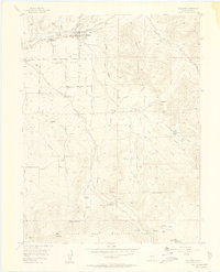
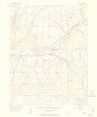
 1956 Westwater 4 SE1956 Print · USGSThe Utah-Colorado borderlands come into focus in the mid-1950s as the railroad follows the serpentine Colorado River. Trace the early infrastructure at Westwater and Utaline or locate the canyons of Westwater Wash.
 - 1956 Map of Moab, 1972 Print
 1956 Moab1972 Print · USGSThe Colorado Plateau and La Sal Mountains appear here in the mid-fifties, just as the uranium boom and energy exploration were reshaping the Four Corners. Researchers can trace the Denver and Rio Grande Western through Cisco or locate the remote outpost of Uravan and Looking Glass Rock.3 unique versions available
 - 1956 Map of Grand Junction, 1973 Print
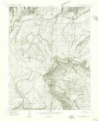
 1956 Grand Junction1973 Print · USGSThe Grand Valley and its surrounding high plateaus are captured here in the mid-twentieth century as the region's ranching and rail heritage remained central. Researchers can trace the path of the Denver & Rio Grande Western RR through Grand Junction or locate remote outposts like Dragon and Atchee.2 unique versions available
 - 1957 Map of Leadville, 1978 Print
 1957 Leadville1978 Print · USGSHigh-country mining and rail transport define the central Colorado Rockies during the mid-to-late twentieth century. Researchers can trace the industrial footprints of Gilman and Climax, find small rail stops like Malta, and follow the Denver and Rio Grande Western RR.2 unique versions available
Showing maps 1-25 of 28
Top cities of Mesa County
- Grand Junction historical maps
- Fruita historical maps
- Palisade historical maps
- Loma historical maps
- De Beque historical maps
- Collbran historical maps
Frequently asked questions
- What are the different types of historical maps available for Mesa County?
- What is the oldest map of Mesa County?
- Where can I purchase historical maps of Mesa County for my home or office?
- Where can I download high-res historical maps of Mesa County?
- Are there historical topographic maps available for Mesa County?
- Is there historical aerial imagery available for Mesa County?
- Where are historical maps of Mesa County sourced from?