1970s Maps of Mesa County, Colorado
Explore 13 historic maps of Mesa County from the 1970s. These maps offer a rare glimpse into what life looked like during the 1970s — showing old roads, neighborhoods, homes, and landmarks that have changed or disappeared over time.
Whether you're researching your family's past, planning a metal detecting trip, or studying how Mesa County's landscape evolved across the 1970s, these high-resolution maps are a powerful tool for exploring the history of this region.
- Focus on a specific era: All maps on this page are from the 1970s, giving you a focused view of this time period.
- See what’s changed: Compare century-old streets, trails, and buildings to today's modern landscape using overlays and satellite layers.
- Research with precision: Use these maps for genealogy, historical research, land use analysis, or educational projects.
- View, download, or print: Maps are fully viewable online in high resolution, and can be downloaded or printed for your own records.
Start exploring Mesa County's history through authentic maps from the 1970s. This is your window into the past.
Mesa County, CO maps
(13)- 1970 Map of Bar X Wash, 1973 Print
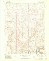
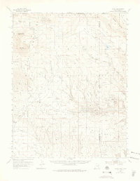
 1970 Bar X Wash1973 Print · USGSThe high-desert borderlands of Grand County and Mesa County are captured here in 1970 during an era of intensive energy exploration. Researchers can trace the network of the Stateline Gas Field and locate industrial landmarks like numerous gas wells and the steep slopes of the Book Cliffs.2 unique versions available
 - 1970 Map of Bitter Creek Well, 1973 Print
 1970 Bitter Creek Well1973 Print · USGSThe Utah-Colorado borderlands come alive in the early 1970s, showcasing a landscape of high-desert washes and deep canyons. Researchers can trace industrial markers like the Denver and Rio Grande Western Railroad, the Old Railroad Grade, and the landmark Bitter Creek Well.4 unique versions available
 - 1972 Map of Casto Reservoir, 1975 Print
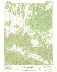
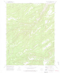
 1972 Casto Reservoir1975 Print · USGSThe Uncompahgre National Forest highlands are captured here in the early seventies, showing a working landscape of ranching and forestry. Trace old mountain access routes like the URANIUM ROAD and find remote sites like Big Creek Ranch or Cold Springs Ranger Sta.
 - 1972 Map of Snyder Flats, 1975 Print
 1972 Snyder Flats1975 Print · USGSMesa County highlands in the early seventies reveal a rugged landscape where the national forests meet at the Unaweep Divide. Trace the remote Jeep Trail networks and family-named landmarks like Enochs Lake and Thimble Rock Point.3 unique versions available
 - 1972 Map of Fish Creek, 1975 Print
 1972 Fish Creek1975 Print · USGSMesa County high country is mapped here in the early seventies, detailing the water systems and forest lands of the western slope. Genealogists and historians can trace family-named landmarks like Tommy Dodson Canyon and Turner Gulch.2 unique versions available
 - 1972 Map of Jacks Canyon, 1975 Print
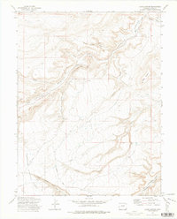 1972 Jacks Canyon1975 Print · USGSMesa County in the early 1970s shows a rugged backcountry of deep canyons and primitive trails. Genealogists and historians can trace old mining prospects at Nancy Hanks Gulch or follow the route of Divide Road as it skirts the Uncompahgre National Forest.2 unique versions available
 - 1972 Map of Keith Creek, 1977 Print
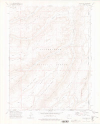
 1972 Keith Creek1977 Print · USGSMesa County is shown during a period of wilderness management and early recreation in the early seventies. Trace high-country routes like Divide Road and explore landmarks such as Winter Camp or the Brushy Ridge Trail.2 unique versions available
 - 1973 Map of Snipe Mountain, 1975 Print
 1973 Snipe Mountain1975 Print · USGSThe high plateau of western Colorado is captured here in the early 1970s, showing the remote ranching and forest lands on the Mesa-Montrose county line. Researchers can trace historic cattle operations through named sites like Blumberg Camp, Musser Cow Camp, and the Beaver Dam Reservoir.3 unique versions available
 - 1973 Map of Starvation Point, 1976 Print
 1973 Starvation Point1976 Print · USGSMontrose and Mesa counties are captured in the early 1970s, showcasing a landscape of high-country cattle camps and mining claims. Genealogists and historians can trace the Copper King Mine, the isolated Fortyseven Cow Camp, and landmarks like Starvation Point.
 - 1973 Map of Uncompahgre Butte, 1976 Print
 1973 Uncompahgre Butte1976 Print · USGSThe Uncompahgre Plateau in the 1970s reveals a high-altitude ranching landscape at the intersection of Mesa and Montrose Counties. Researchers can trace seasonal grazing sites like U C Cow Camp, old livestock routes such as Dominguez Trail, and remote features like Campbell Lake.
 - 1973 Map of Kelso Point, 1976 Print
 1973 Kelso Point1976 Print · USGSMesa and Montrose counties are shown here in the early 1970s, showcasing a landscape of isolated mesas and deep creek forks. Researchers can trace the remote Picket Corral Ranch and high-altitude landmarks like Love Lake and Sawmill Mesa.3 unique versions available
 - 1973 Map of Escalante Forks, 1977 Print
 1973 Escalante Forks1977 Print · USGSMesa and Delta counties in the early 1970s reveal a high-plateau landscape defined by remote forest service trails and vital water sources. Researchers can trace historic stock routes and mountain outposts like the Gunnison Palmer Trail, Remlap, and Steamboat Spring.3 unique versions available
 - 1974 Map of La Sal, 1975 Print
 1974 La Sal1975 Print · USGSThe high plateau and jagged peaks of the Utah-Colorado border come alive in the 1970s, showing a landscape defined by ranching and Cold War-era mining. Genealogists and historians can trace old homesteads like Pine Lodge Ranch or locate the numerous named claims including the Vanadium Queen Mine and Uranium Girl Mine.
End of results
Showing maps 1-13 of 13
Top cities of Mesa County
- Grand Junction historical maps
- Fruita historical maps
- Palisade historical maps
- Loma historical maps
- De Beque historical maps
- Collbran historical maps
Frequently asked questions
- What are the different types of historical maps available for Mesa County?
- What is the oldest map of Mesa County?
- Where can I purchase historical maps of Mesa County for my home or office?
- Where can I download high-res historical maps of Mesa County?
- Are there historical topographic maps available for Mesa County?
- Is there historical aerial imagery available for Mesa County?
- Where are historical maps of Mesa County sourced from?