1970s Maps of Tybee Island, Georgia
Explore 5 historic maps of Tybee Island from the 1970s. These maps offer a rare glimpse into what life looked like during the 1970s — showing old roads, neighborhoods, homes, and landmarks that have changed or disappeared over time.
Whether you're researching your family's past, planning a metal detecting trip, or studying how Tybee Island's landscape evolved across the 1970s, these high-resolution maps are a powerful tool for exploring the history of this region.
- Focus on a specific era: All maps on this page are from the 1970s, giving you a focused view of this time period.
- See what’s changed: Compare century-old streets, trails, and buildings to today's modern landscape using overlays and satellite layers.
- Research with precision: Use these maps for genealogy, historical research, land use analysis, or educational projects.
- View, download, or print: Maps are fully viewable online in high resolution, and can be downloaded or printed for your own records.
Start exploring Tybee Island's history through authentic maps from the 1970s. This is your window into the past.
Tybee Island, GA maps
(5)- 1978 Map of Tybee Island North
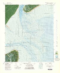 1978 Tybee Island North1978 Print · USGSThe Georgia and South Carolina coastlines meet in the late seventies at the mouth of the Savannah River. Maritime historians and coastal researchers can trace the historic fortifications at Fort Screven and the shifting shoals around Bloody Pt and Tybee Knoll Spit.
 - 1978 Map of Fort Pulaski
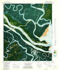 1978 Fort Pulaski1978 Print · USGSThe coastal borderlands of Georgia and South Carolina are captured here in the late seventies, showing the tidal marshes where the Savannah River meets the sea. Researchers can trace the Old Railroad Grade and locate historic markers like Daufuskie Landing and Fort Pulaski National Monument.2 unique versions available
 - 1978 Map of Beaufort
 1978 Beaufort1978 Print · USGSCoastal South Carolina and Georgia come to life in this detailed bathymetric study from the late seventies, featuring the intricate Sea Islands and the Savannah River mouth. Researchers can trace military history at Parris Island or locate inland settlements like Switzerland and Old Sheldon.2 unique versions available
 - 1978 Map of Brunswick
 1978 Brunswick1978 Print · USGSThe Georgia coast and its barrier islands are captured in the late 1970s, as I-95 and the rail lines shaped the growth of coastal towns. Genealogists and historians can trace family locations across the islands or locate sites near Fort Stewart, Darien, and Ludowici.2 unique versions available
 - 1979 Map of Tybee Island South
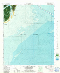 1979 Tybee Island South1979 Print · USGSTybee Island and the Georgia coast are captured here in the late seventies during a period of active shoreline management. Researchers can trace the Beach Renourished 1976 zone and locate coastal settlements like Spanish Hammock and South End.2 unique versions available
End of results
Showing maps 1-5 of 5
Top cities near Tybee Island
- Savannah historical maps
- Hilton Head Island historical maps
- Wilmington Island historical maps
- Skidaway Island historical maps
- Whitemarsh Island historical maps
- Bluffton historical maps
See more
Frequently asked questions
- What are the different types of historical maps available for Tybee Island?
- What is the oldest map of Tybee Island?
- Where can I purchase historical maps of Tybee Island for my home or office?
- Where can I download high-res historical maps of Tybee Island?
- Are there historical topographic maps available for Tybee Island?
- Is there historical aerial imagery available for Tybee Island?
- Where are historical maps of Tybee Island sourced from?