1930s Maps of Hawaii
Explore 3 historic maps of Hawaii from the 1930s. These maps offer a rare glimpse into what life looked like during the 1930s — showing old roads, neighborhoods, homes, and landmarks that have changed or disappeared over time.
Whether you're researching your family's past, planning a metal detecting trip, or studying how Hawaii's landscape evolved across the 1930s, these high-resolution maps are a powerful tool for exploring the history of this region.
- Focus on a specific era: All maps on this page are from the 1930s, giving you a focused view of this time period.
- See what’s changed: Compare century-old streets, trails, and buildings to today's modern landscape using overlays and satellite layers.
- Research with precision: Use these maps for genealogy, historical research, land use analysis, or educational projects.
- View, download, or print: Maps are fully viewable online in high resolution, and can be downloaded or printed for your own records.
Start exploring Hawaii's history through authentic maps from the 1930s. This is your window into the past.
Hawaii maps
(3)- 1930 Map of Humuula
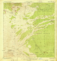 1930 Humuula1930 Print · USGSThe slopes of Mauna Kea and the high saddle lands appear here in the late twenties, dominated by massive historical lava paths. Trace the roots of the island's ranching and conservation history at the Humuula Sheep Station and the Kilauea Forest Reserve.3 unique versions available
 - 1930 Map of Kaohe
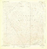 1930 Kaohe1930 Print · USGSThe high volcanic slopes of Hawaii's interior are captured during the territorial era, showcasing the massive Lava Flow of 1859 and Keamuku Lava Flow. Trace the routes of the Mauna Loa Volcano House Trail and find landmarks like Pukauahi.3 unique versions available
 - 1932 Map of Hilo
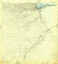 1932 Hilo1932 Print · USGSCoastal Hawaii and the Puna district appear here at the height of the plantation era, before major mid-century modernization. Researchers can trace the layout of sugar camps and early rail lines, locating the Olaa Plantation Mill, the Hilo Air Port, and the track of the Lava Flow of 1881.2 unique versions available
End of results
Showing maps 1-3 of 3
Top cities of Hawaii
- Honolulu historical maps
- Waipahu historical maps
- East Honolulu historical maps
- Mililani historical maps
- Pearl City historical maps
- Hilo historical maps
See more
Top counties of Hawaii
- Honolulu County historical maps
- Hawaiʻi County historical maps
- Maui County historical maps
- Kauai County historical maps
Frequently asked questions
- What are the different types of historical maps available for Hawaii?
- What is the oldest map of Hawaii?
- Where can I purchase historical maps of Hawaii for my home or office?
- Where can I download high-res historical maps of Hawaii?
- Are there historical topographic maps available for Hawaii?
- Is there historical aerial imagery available for Hawaii?
- Where are historical maps of Hawaii sourced from?