1920s Maps of Hawaii
Explore 17 historic maps of Hawaii from the 1920s. These maps offer a rare glimpse into what life looked like during the 1920s — showing old roads, neighborhoods, homes, and landmarks that have changed or disappeared over time.
Whether you're researching your family's past, planning a metal detecting trip, or studying how Hawaii's landscape evolved across the 1920s, these high-resolution maps are a powerful tool for exploring the history of this region.
- Focus on a specific era: All maps on this page are from the 1920s, giving you a focused view of this time period.
- See what’s changed: Compare century-old streets, trails, and buildings to today's modern landscape using overlays and satellite layers.
- Research with precision: Use these maps for genealogy, historical research, land use analysis, or educational projects.
- View, download, or print: Maps are fully viewable online in high resolution, and can be downloaded or printed for your own records.
Start exploring Hawaii's history through authentic maps from the 1920s. This is your window into the past.
Hawaii maps
(17)- 1921 Map of Kilauea, 1954 Print
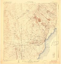
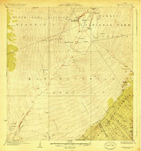
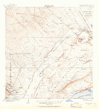 1921 Kilauea1954 Print · USGSThe volcanic heart of the Big Island is captured here in the early twentieth century, showing the intersection of geological wonder and early territorial development. Genealogists and historians can locate early family lands at the Wood Valley Homesteads or trace the routes of the Old Kau-Volcano Trail and the Old Puna-Kau Trail.2 unique versions available
 - 1922 Map of Puna, 1957 Print
 1922 Puna1957 Print · USGSThe Puna district of Hawaii is captured here during the early twentieth century as the national park was taking shape. Researchers can locate ancient coastal sites like Wahaula Heiau and early homesteads at Kilauea Settlement Lots.
 - 1923 Map of Island of Lanai
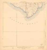
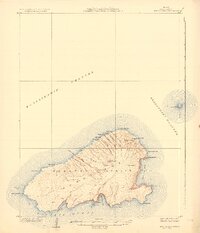
 1923 Island of Lanai1923 Print · USGSLanai in the early twenties reveals a landscape of deep gulches and emerging inland settlement just as the pineapple era began. Trace coastal landmarks like Keomuku PO and Halepalaoa Landing or explore the harbor at Kaumalapau Harbor.2 unique versions available
 - 1923 Map of Pahala
 1923 Pahala1923 Print · USGSThe Kau District coast and its labor settlements are captured in the early 1920s during the Territory of Hawaii era. Genealogists and historians can locate specific housing at Paho Camp and Keaiwa Camp or trace the volcanic landscape from the Great Crack to the ancient Kuee Ruins.3 unique versions available
 - 1924 Map of Makuu
 1924 Makuu1924 Print · USGSThe Puna coastline in the early twentieth century was a landscape of rail-linked plantations and volcanic terrain. You can trace the Hawaii Consolidated Railway as it services Honolulu Landing and the Nanawale Homesteads near the Lava Flow of 1840.3 unique versions available
 - 1924 Map of Kalae
 1924 Kalae1924 Print · USGSThe southern tip of the Big Island in the 1920s shows a landscape of recent lava flows and sacred Hawaiian sites. Researchers can trace the Lava Flow of 1887, identify the Kamaoa Homesteads, and locate ancient temples like Ka Heiau o Kalalea.3 unique versions available
 - 1924 Map of Kilauea
 1924 Kilauea1924 Print · USGSThe volcanic highlands of Hawaii Island are captured here during a period of active transformation in the early twenties. Researchers can trace the early hospitality and military sites at Volcano House and Kilauea Military Camp, plus working landscapes like Keauhou Ranch.5 unique versions available
 - 1924 Map of Puna
 1924 Puna1924 Print · USGSThe Puna coastline and the volcanic highlands of Hawaii are captured here in the early twenties, during the growth of local homesteading and ranching. Genealogists and historians can locate early residents in the Kilauea Settlement Lots or trace the path of the Hawaii Consolidated Ry near Glenwood.2 unique versions available
 - 1924 Map of Kalapana
 1924 Kalapana1924 Print · USGSThe Puna coastline comes to life in the early twenties, showing a landscape of volcanic craters and early homesteading tracts. Genealogists and historians can locate family lands like the Kaniahiku Homesteads or trace the Consolidated Hawaii Railway to the village of Pahoa.4 unique versions available
 - 1924 Map of Honuapo
 1924 Honuapo1924 Print · USGSThe southern coast of the Big Island during the plantation era is captured here, showing a landscape shaped by recent volcanism. Trace old homesteads and labor quarters like Waiohinu, Naalehu, and the remote Wright Camp alongside the massive Lava Flow of 1916.3 unique versions available
 - 1925 Map of Island of Lanai
 1925 Island of Lanai1925 Print · USGSLanai is mapped here during the mid-twenties, showing the island's transition into a centralized plantation economy. Genealogists and historians can trace the early layout of Lanai City, the coastal Keomuku P O, and the ancient Kaa Fishpond.
 - 1927 Map of Kaohe, 1954 Print
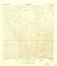 1927 Kaohe1954 Print · USGSThe high volcanic slopes of the Big Island are captured here in the late twenties, detailing massive historical eruptions. Researchers can trace the Mauna Loa Volcano House Trail and the boundaries of the Lava Flow of 1859.
 - 1928 Map of Puako
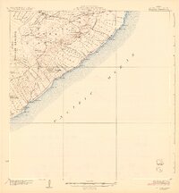
 1928 Puako1928 Print · USGSThe West Hawaii coast in the late twenties reveals a landscape shaped by volcanic activity and ranching. Trace the paths of the Lava Flow of 1859 and Lava Flow of 1801 as they reach the sea near Puako and Kiholo.2 unique versions available
 - 1928 Map of Kailua
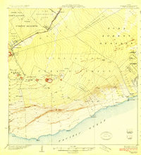
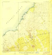
 1928 Kailua1928 Print · USGSThe West Hawaii coast and the heights of Puu Hualalei come into focus in the late 1920s. Genealogists and historians can trace family land in the Kealakehe Homesteads or locate cultural landmarks like Ahuena Heiau and the Kona Mill.3 unique versions available
 - 1928 Map of Mauna Loa
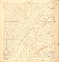
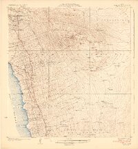
 1928 Mauna Loa1928 Print · USGSMauna Loa was a landscape of recent activity in the late twenties, showing fresh paths of destruction and ancient transit routes. Trace the reach of the Lava Flow of 1926 and find high-altitude landmarks like Sleeping Cave and Umi Cavern.4 unique versions available
 - 1928 Map of Hoopuloa, 1933 Print
 1928 Hoopuloa1933 Print · USGSThe southwest Hawaii coastline in the mid-1920s shows a landscape transformed by volcanic activity and early land settlement. Researchers can trace the paths of recent lava flows and locate specific cultural sites like Milolii, Ohin Mill, and the Alika Homesteads.
 - 1929 Map of Kahoolawe
 1929 Kahoolawe1929 Print · USGSKahoolawe and the surrounding channels are depicted in detail during the late 1920s, showing the island's topography while it was still part of the territorial ranching era. Researchers can trace landforms and landmarks like the Heiau, the crater Lua Makika, and the Molokini islet.3 unique versions available
End of results
Showing maps 1-17 of 17
Top cities of Hawaii
- Honolulu historical maps
- Waipahu historical maps
- East Honolulu historical maps
- Mililani historical maps
- Pearl City historical maps
- Hilo historical maps
See more
Top counties of Hawaii
- Honolulu County historical maps
- Hawaiʻi County historical maps
- Maui County historical maps
- Kauai County historical maps
Frequently asked questions
- What are the different types of historical maps available for Hawaii?
- What is the oldest map of Hawaii?
- Where can I purchase historical maps of Hawaii for my home or office?
- Where can I download high-res historical maps of Hawaii?
- Are there historical topographic maps available for Hawaii?
- Is there historical aerial imagery available for Hawaii?
- Where are historical maps of Hawaii sourced from?