1900-1909 Maps of Boise County, Idaho
Explore 2 historic maps of Boise County from 1900-1909. These maps offer a rare glimpse into what life looked like during the 1900s — showing old roads, neighborhoods, homes, and landmarks that have changed or disappeared over time.
Whether you're researching your family's past, planning a metal detecting trip, or studying how Boise County's landscape evolved across the 1900s, these high-resolution maps are a powerful tool for exploring the history of this region.
- Focus on a specific era: All maps on this page are from the 1900s, giving you a focused view of this time period.
- See what’s changed: Compare century-old streets, trails, and buildings to today's modern landscape using overlays and satellite layers.
- Research with precision: Use these maps for genealogy, historical research, land use analysis, or educational projects.
- View, download, or print: Maps are fully viewable online in high resolution, and can be downloaded or printed for your own records.
Start exploring Boise County's history through authentic maps from the 1900s. This is your window into the past.
Boise County, ID maps
(2)- 1900 Map of Sawtooth
 1900 Sawtooth1900 Print · USGSThe high Idaho backcountry was a hub of hard-rock mining and remote outposts during the late 1890s. Genealogists and historians can trace the foundations of silver-era camps like Carrietown and Vienna or locate industrial sites like the Silver King Mine and Columbia Mill.4 unique versions available
 - 1909 Map of Garden Valley
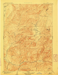 1909 Garden Valley1909 Print · USGSThe Idaho backcountry in the late nineteenth century was a frontier of river canyons and high timber. Researchers can trace the early footprints of Lowman and Banner or follow the primitive drainages of the Deadwood River and Grimes Creek.2 unique versions available
End of results
Showing maps 1-2 of 2
Top cities of Boise County
- Robie Creek historical maps
- Horseshoe Bend historical maps
- Idaho City historical maps
- Crouch historical maps
- Placerville historical maps
Frequently asked questions
- What are the different types of historical maps available for Boise County?
- What is the oldest map of Boise County?
- Where can I purchase historical maps of Boise County for my home or office?
- Where can I download high-res historical maps of Boise County?
- Are there historical topographic maps available for Boise County?
- Is there historical aerial imagery available for Boise County?
- Where are historical maps of Boise County sourced from?