Old Maps of Boise County, Idaho for Academic Research
Study the evolution of Boise County with 369 high-resolution historic maps. Whether you're teaching, researching, or modeling changes in land use, these maps provide essential visual documentation of urban, environmental, and geographic change.
- Analyze long-term change: Track patterns in development, transportation, and natural features.
- Ideal for environmental or urban studies: Support academic projects with primary historical map data.
- Use in the classroom or lab: Educators and researchers rely on these maps to bring historical context to life.
These maps are a powerful tool for teaching, research, and visualizing how Boise County has changed over the decades.
Boise County, ID maps
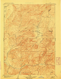
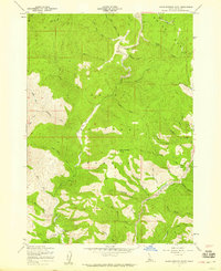
(369)- 1891 Map of Bear Valley, 1963 Print
 1891 Bear Valley1963 Print · USGSThe Idaho wilderness at the close of the nineteenth century is captured here in this early reconnaissance survey. Researchers can trace the pristine headwaters of the Middle Fork Salmon River and locate historic landmarks like Stanley Lake and Tyee Mtn.
 - 1892 Map of Boise
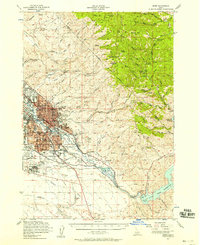
 1892 Boise1892 Print · USGSThe Boise Valley and surrounding highlands are shown here in the early 1890s as irrigation and railroads transformed the Idaho territory. Researchers can trace the early city grid near Boise Barracks and the paths of the Idaho Central Railroad and the Settlers Canal.
 - 1893 Map of Bear Valley
 1893 Bear Valley1893 Print · USGSCentral Idaho in the early 1890s was a wilderness of intersecting watersheds and mountain peaks long before modern infrastructure arrived. Trace the headwaters of the Salmon River and Payette River near Cape Horn and the Sawtooth Range.5 unique versions available
 - 1894 Map of Squaw Creek
 1894 Squaw Creek1894 Print · USGSCentral Idaho in the 1890s was a landscape of mountain valleys and river crossings where early pioneers established remote outposts. Trace the locations of historic river access at Smith Ferry and early industry at Walker Mill or the settlement of Ola.5 unique versions available
 - 1894 Map of Idaho Basin
 1894 Idaho Basin1894 Print · USGSThe Idaho Basin at the height of the mining era is revealed here through its network of camps and mountain trails. Genealogists and historians can trace early settlements like Pioneerville, Idaho City, and Placerville alongside landmarks like Halfway House.7 unique versions available
 - 1894 Map of Rocky Bar
 1894 Rocky Bar1894 Print · USGSElmore County was a landscape of high-altitude mining camps and river forks in the 1890s. Genealogists and researchers can trace the early layout of remote mountain outposts like Atlanta and Rocky Bar or the banks of the South Fork Boise River.5 unique versions available
 - 1897 Map of Boise
 1897 Boise1897 Print · USGSBoise and the surrounding valley are captured here in the late nineteenth century as irrigation and rail networks began to reshape the high desert. Researchers can trace early water rights through the Settlers Canal or locate historic sites like the Boise Barracks and the Natatorium.4 unique versions available
 - 1900 Map of Sawtooth
 1900 Sawtooth1900 Print · USGSThe high Idaho backcountry was a hub of hard-rock mining and remote outposts during the late 1890s. Genealogists and historians can trace the foundations of silver-era camps like Carrietown and Vienna or locate industrial sites like the Silver King Mine and Columbia Mill.4 unique versions available
 - 1909 Map of Garden Valley
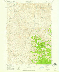
 1909 Garden Valley1909 Print · USGSThe Idaho backcountry in the late nineteenth century was a frontier of river canyons and high timber. Researchers can trace the early footprints of Lowman and Banner or follow the primitive drainages of the Deadwood River and Grimes Creek.2 unique versions available
 - 1919 Map of Custer, 1964 Print
 1919 Custer1964 Print · USGSCuster County was a rugged hub of mining and forestry in the years following the Great War. Genealogists and historians can trace the early footprint of Custer, Bonanza, and the Sunbeam Mine, or locate the original Valley Creek Ranger Station.
 - 1922 Map of Custer
 1922 Custer1922 Print · USGSThe Salmon River high country comes alive in the years following the Great War, showing a landscape of isolated mining camps and early forest service outposts. Genealogists and researchers can trace the roads and trails connecting Custer, Bonanza, and the Sunbeam Mine.3 unique versions available
 - 1949 Map of Robie Creek, 1986 Print
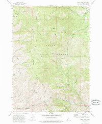 1949 Robie Creek1986 Print · USGSThe high country northeast of Boise is captured here in the early seventies, showing a landscape of mineral prospects and forest summits. Trace old mining activity at Bumblebee Mine or locate historical routes near Davidson Ranch and Aldape Summit.
 - 1953 Map of Banks, 1955 Print
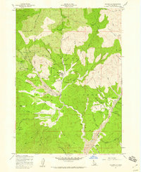
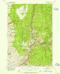 1953 Banks1955 Print · USGSThe confluence of the Payette River forks defines this mid-century survey of Boise and Valley counties. Genealogists can trace the rural mountain life of the early fifties through the High Valley Sch (Aband), Pinehurst Church, and the settlement of Banks.3 unique versions available
 - 1953 Map of Montour, 1956 Print
 1953 Montour1956 Print · USGSThe Payette River valley in the early fifties shows a landscape of reclamation and resource extraction. Researchers can trace the rail corridor of the Union Pacific or locate early mining sites like the Gem State Mine and the Sweet Cemetery.3 unique versions available
 - 1954 Map of Boise North, 1957 Print
 1954 Boise North1957 Print · USGSBoise and Garden City are captured in the mid-fifties as the city began to climb the foothills and expand along the river. Genealogists and local historians can locate early institutions like the Soldiers Home, Collister Sch, and the Boise City Canal.2 unique versions available
 - 1954 Map of Boise, 1958 Print
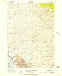
 1954 Boise1958 Print · USGSBoise and the surrounding Idaho foothills are captured here in the mid-fifties, just as suburban expansion began meeting the rugged edge of the Boise National Forest. Researchers can trace the Old Oregon Trail, locate the State Penitentiary, and find long-established schools like St Marys Sch.2 unique versions available
 - 1955 Map of Baker, 1964 Print
 1955 Baker1964 Print · USGSThe Oregon-Idaho borderlands are captured here in the mid-fifties as the Snake River underwent massive changes from dam construction. Trace the Oregon Trail Memorial Monument near Baker, find early mines like Virtue Mine, and follow the Union Pacific Railroad through Huntington.4 unique versions available
 - 1955 Map of Hailey, 1968 Print
 1955 Hailey1968 Print · USGSCentral Idaho in the mid-fifties reveals a landscape transitioning from deep-rooted silver mining to a burgeoning outdoor economy. Researchers can trace the legacy of the Union Pacific line, the remote Triumph Mine, and original airfield layouts at Mountain Home Air Force Base.4 unique versions available
 - 1955 Map of Boise, 1977 Print
 1955 Boise1977 Print · USGSThe Treasure Valley and Owyhee uplands are shown in detail during the mid-fifties, capturing the region's transition into a major agricultural and urban hub. Researchers can trace the Union Pacific line through Nampa, explore the volcanic Jordan Craters, or locate the historic mining district of Silver City.
 - 1957 Map of Cartwright Canyon, 1959 Print
 1957 Cartwright Canyon1959 Print · USGSThe foothills north of Boise during the late 1950s remained a terrain of remote ranching and timber access. Researchers can trace the original route of Horseshoe Bend Road and locate family landmarks like Dobson Ranch and Stack Rock.4 unique versions available
 - 1957 Map of Horseshoe Bend, 1959 Print
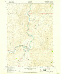 1957 Horseshoe Bend1959 Print · USGSThe Payette River valley comes alive in the late fifties, showing a landscape of rail-fed industry and mountain settlements. Trace the timber and transit heritage at Horseshoe Bend, the Pioneer Cemetery, and the riverside Union Pacific line.3 unique versions available
 - 1957 Map of Placerville, 1959 Print
 1957 Placerville1959 Print · USGSIn the Idaho mountains during the late 1950s, this area shows a landscape transformed by the search for gold. Genealogists and historians can locate mining landmarks like Quartzburg, the Gold Hill Mine, and the old cemeteries near Centerville.3 unique versions available
 - 1957 Map of Pioneerville, 1959 Print
 1957 Pioneerville1959 Print · USGSThe Idaho Basin’s gold mining legacy is on full display here during the late fifties, centered on the settlement of Pioneerville. Genealogists and historians can trace lode claims and ranch sites like Arbaugh Ranch or the Washington Mill.4 unique versions available
 - 1957 Map of Warm Springs Point, 1959 Print
 1957 Warm Springs Point1959 Print · USGSBoise County was a center of resource extraction and forest management in the late fifties. Researchers can trace the legacy of mining through Tailings along Grimes Creek or locate landmarks like Holcomb Guard Station and Warm Springs Point.4 unique versions available
 - 1957 Map of Shafer Butte, 1959 Print
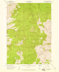 1957 Shafer Butte1959 Print · USGSThe Boise Ridge comes into focus in the late 1950s as a burgeoning recreational and media hub. Researchers can trace the early development of Bogus Basin State Park and locate historic communication sites like the KBOI-TV Towers near Shafer Butte.4 unique versions available
Showing maps 1-25 of 369
Top cities of Boise County
- Robie Creek historical maps
- Horseshoe Bend historical maps
- Idaho City historical maps
- Crouch historical maps
- Placerville historical maps
Frequently asked questions
- What are the different types of historical maps available for Boise County?
- What is the oldest map of Boise County?
- Where can I purchase historical maps of Boise County for my home or office?
- Where can I download high-res historical maps of Boise County?
- Are there historical topographic maps available for Boise County?
- Is there historical aerial imagery available for Boise County?
- Where are historical maps of Boise County sourced from?