1980s Maps of Boise County, Idaho
Explore 16 historic maps of Boise County from the 1980s. These maps offer a rare glimpse into what life looked like during the 1980s — showing old roads, neighborhoods, homes, and landmarks that have changed or disappeared over time.
Whether you're researching your family's past, planning a metal detecting trip, or studying how Boise County's landscape evolved across the 1980s, these high-resolution maps are a powerful tool for exploring the history of this region.
- Focus on a specific era: All maps on this page are from the 1980s, giving you a focused view of this time period.
- See what’s changed: Compare century-old streets, trails, and buildings to today's modern landscape using overlays and satellite layers.
- Research with precision: Use these maps for genealogy, historical research, land use analysis, or educational projects.
- View, download, or print: Maps are fully viewable online in high resolution, and can be downloaded or printed for your own records.
Start exploring Boise County's history through authentic maps from the 1980s. This is your window into the past.
Boise County, ID maps
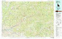
(16)- 1980 Map of Weiser, 1993 Print
 1980 Weiser1993 Print · USGSThe Snake River valley and the foothills of the Boise Mountains are captured here in the 1980s, showing the vital rail and water infrastructure of the region. Researchers can trace the Union Pacific line through Payette or locate rural landmarks like Hog Cove Butte and Wilburn Butte.
 - 1981 Map of Boise
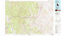
 1981 Boise1981 Print · USGSThe Boise River valley and Treasure Plain are captured here in the early eighties as urban expansion began to link the regional hubs of the Snake River plain. Researchers can trace the development of Nampa, Caldwell, and Meridian or locate landmarks like Lake Lowell and Eagle Island State Park.2 unique versions available
 - 1982 Map of Idaho City
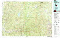
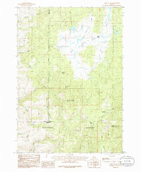
 1982 Idaho City1982 Print · USGSThe Boise Basin and surrounding mountains appear in the early 1980s as a land transitioning from its gold-mining roots to a recreation-focused forest landscape. Researchers can trace historic mining operations at the Gold Hill Mine or locate remote settlements like Atlanta, Rocky Bar, and Featherville.
 - 1982 Map of White Cloud Peaks
 1982 White Cloud Peaks1982 Print · USGSCuster County in the early eighties is a landscape where high-mountain recreation meets a legacy of hard-rock mining. Genealogists and researchers can trace the roads to Custer, locate isolated sites like the Livingston Mine, or find the waters of Redfish Lake.2 unique versions available
 - 1982 Map of Deadwood River
 1982 Deadwood River1982 Print · USGSCentral Idaho in the early eighties was a vast expanse of protected wilderness and remote river canyons. Local historians and hunters can locate early landmarks like the Mary Jane Mine, the settlement of Lowman, and isolated facilities such as the Bruce Meadows Landing Strip.
 - 1985 Map of Banks, 1986 Print
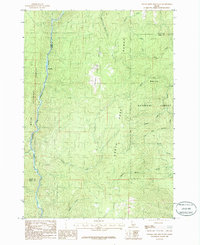
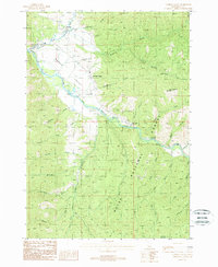
 1985 Banks1986 Print · USGSThe North Fork Payette River corridor comes to life in the mid-eighties as it winds through the Boise National Forest. Researchers can trace the riverfront at Banks and Zimmer or locate mountain landmarks like Boise Mountain and Fleming Creek.
 - 1985 Map of Packer John Mountain, 1986 Print
 1985 Packer John Mountain1986 Print · USGSThe Boise National Forest landscape is shown here during the mid-1980s, centered on the high ridgelines of the Packer John Mountain Range. Researchers can trace the drainage systems of Scriver Creek and the river bend at Big Eddy.
 - 1985 Map of Pearl, 1986 Print
 1985 Pearl1986 Print · USGSThe mining community of Pearl is captured in the mid-1980s, surrounded by a landscape etched with geological exploration. Researchers can identify numerous prospects and a Mine Shaft near Prospect Peak, or trace the winding courses of North Fork Willow Creek and Spring Valley Creek.
 - 1985 Map of Montour, 1986 Print
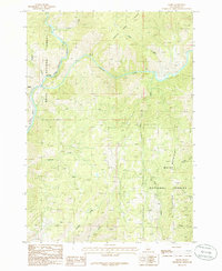
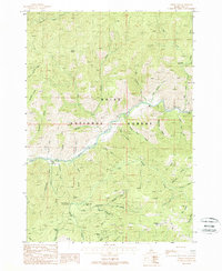
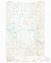 1985 Montour1986 Print · USGSThe Payette River and Sweet Valley are captured here in the mid-1980s, showcasing the intersection of canyon terrain and riverside settlement. Genealogists and researchers can trace local landmarks like Roystone Hot Springs, the community of Sweet, and the waters of Black Canyon Reservoir.
 - 1985 Map of Dry Buck Valley, 1986 Print
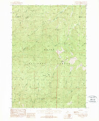
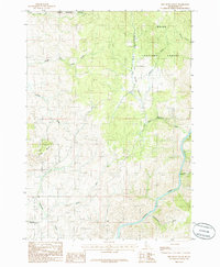 1985 Dry Buck Valley1986 Print · USGSBoise County's rugged forest lands are detailed here during the mid-1980s, centered on the Dry Buck Valley watershed. Local researchers can trace old drainage routes through the Boise National Forest and locate industrial Gravel Pits near Timber Butte.
 - 1985 Map of High Valley, 1986 Print
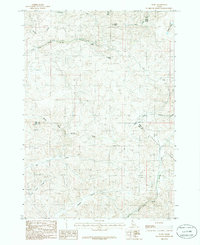
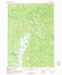
 1985 High Valley1986 Print · USGSThe high timberlands and headwaters of the Boise National Forest are captured here in the mid-eighties. Genealogists and historians can trace old forestry routes and high-country landmarks like High Valley, Dry Buck Meadow, and Ola Summit.
 - 1988 Map of Lightning Ridge, 1989 Print
 1988 Lightning Ridge1989 Print · USGSThe high backcountry of the Boise National Forest is captured here in the late 1980s, centered on the dramatic divide between Valley and Boise counties. Researchers can trace remote hydrology and access points like Scott Mountain 8214 Lookout, Granite Basin, and the trail winding along Lightning Ridge.
 - 1988 Map of Grimes Pass, 1989 Print
 1988 Grimes Pass1989 Print · USGSThe Boise National Forest backcountry in the late 1980s reveals a landscape shaped by high-country mining and timber. Genealogists and historians can trace old claims like the Golden Age Mine and local landmarks such as the Grimes Monument at Grimes Pass.
 - 1988 Map of Pyle Creek, 1989 Print
 1988 Pyle Creek1989 Print · USGSThe Boise National Forest meets the forks of the Payette River in the late eighties, documenting a landscape of steep ridges and riverside recreation. Trace early forest access at Hardscrabble Campground, Tie Creek Campground, and a Golf Course near Warm Springs Creek.
 - 1988 Map of Garden Valley, 1989 Print
 1988 Garden Valley1989 Print · USGSGarden Valley and Crouch are centered in this late-century study of the Payette River forks. Genealogists can find the Garden Valley Pioneer Cemetery, while others can trace forest landmarks like the Garden Valley Ranger Station and Hot Springs Campground.2 unique versions available
 - 1989 Map of Challis
 1989 Challis1989 Print · USGSCentral Idaho in the late eighties remains a vast expanse of protected wilderness and high-mountain drainages. Researchers can trace remote settlements and backcountry outposts like Custer, Stibnite, and Sunbeam along the Salmon River and its many forks.2 unique versions available
End of results
Showing maps 1-16 of 16
Top cities of Boise County
- Robie Creek historical maps
- Horseshoe Bend historical maps
- Idaho City historical maps
- Crouch historical maps
- Placerville historical maps
Frequently asked questions
- What are the different types of historical maps available for Boise County?
- What is the oldest map of Boise County?
- Where can I purchase historical maps of Boise County for my home or office?
- Where can I download high-res historical maps of Boise County?
- Are there historical topographic maps available for Boise County?
- Is there historical aerial imagery available for Boise County?
- Where are historical maps of Boise County sourced from?