1990s Maps of Boise County, Idaho
Explore 5 historic maps of Boise County from the 1990s. These maps offer a rare glimpse into what life looked like during the 1990s — showing old roads, neighborhoods, homes, and landmarks that have changed or disappeared over time.
Whether you're researching your family's past, planning a metal detecting trip, or studying how Boise County's landscape evolved across the 1990s, these high-resolution maps are a powerful tool for exploring the history of this region.
- Focus on a specific era: All maps on this page are from the 1990s, giving you a focused view of this time period.
- See what’s changed: Compare century-old streets, trails, and buildings to today's modern landscape using overlays and satellite layers.
- Research with precision: Use these maps for genealogy, historical research, land use analysis, or educational projects.
- View, download, or print: Maps are fully viewable online in high resolution, and can be downloaded or printed for your own records.
Start exploring Boise County's history through authentic maps from the 1990s. This is your window into the past.
Boise County, ID maps
(5)- 1992 Map of Sun Valley, 1993 Print
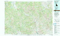 1992 Sun Valley1993 Print · USGSThe Wood River Valley and surrounding high peaks are documented here in the early nineties, showing the region's shift toward a recreation economy. Researchers can trace the legacy of mining and mountain development at the Triumph Mine, Sun Valley, and Alturas Lake.2 unique versions available
 - 1998 Map of Cartwright Canyon, 2002 Print
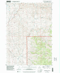 1998 Cartwright Canyon2002 Print · USGSThe foothills north of Boise are shown here at the close of the twentieth century, just as the region began a period of rapid change. Researchers can locate remote homesteads like Dobson Ranch and landmarks such as Bread Loaf Rock and Stack Rock.
 - 1998 Map of Placerville, 2002 Print
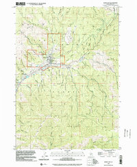
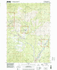 1998 Placerville2002 Print · USGSThe mining landscapes of Boise County are preserved here as they appeared in the late nineties, documenting the enduring footprint of the Idaho Basin gold rush. Genealogists and researchers can locate family sites and old claims like Brassey Ranch, Gold Hill Mine, and the town of Placerville.
 - 1998 Map of Horseshoe Bend, 2002 Print
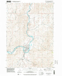 1998 Horseshoe Bend2002 Print · USGSHorseshoe Bend and the Payette River corridor are captured here at the turn of the millennium. Researchers can trace the local industrial footprint from the Powerhouse to Pioneer Cemetery and the rural siding at Gardena.
 - 1998 Map of Idaho City, 2002 Print
 1998 Idaho City2002 Print · USGSIdaho City and the surrounding Boise Basin are shown here in the late nineties, documenting a landscape defined by decades of resource extraction. Researchers can locate the historic Boot Hill Cem, the Gold Hill Mine, and the Boise Basin Experiment Sta among a complex network of named gulches like Laraway Gulch.
End of results
Showing maps 1-5 of 5
Top cities of Boise County
- Robie Creek historical maps
- Horseshoe Bend historical maps
- Idaho City historical maps
- Crouch historical maps
- Placerville historical maps
Frequently asked questions
- What are the different types of historical maps available for Boise County?
- What is the oldest map of Boise County?
- Where can I purchase historical maps of Boise County for my home or office?
- Where can I download high-res historical maps of Boise County?
- Are there historical topographic maps available for Boise County?
- Is there historical aerial imagery available for Boise County?
- Where are historical maps of Boise County sourced from?