1970s Maps of Trego County, Kansas
Explore 16 historic maps of Trego County from the 1970s. These maps offer a rare glimpse into what life looked like during the 1970s — showing old roads, neighborhoods, homes, and landmarks that have changed or disappeared over time.
Whether you're researching your family's past, planning a metal detecting trip, or studying how Trego County's landscape evolved across the 1970s, these high-resolution maps are a powerful tool for exploring the history of this region.
- Focus on a specific era: All maps on this page are from the 1970s, giving you a focused view of this time period.
- See what’s changed: Compare century-old streets, trails, and buildings to today's modern landscape using overlays and satellite layers.
- Research with precision: Use these maps for genealogy, historical research, land use analysis, or educational projects.
- View, download, or print: Maps are fully viewable online in high resolution, and can be downloaded or printed for your own records.
Start exploring Trego County's history through authentic maps from the 1970s. This is your window into the past.
Trego County, KS maps
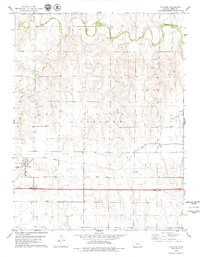
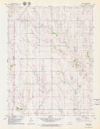
(16)- 1972 Map of Castle Rock NW, 1974 Print
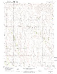
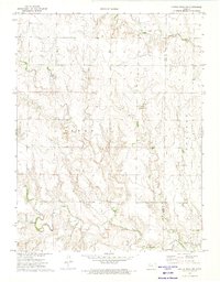 1972 Castle Rock NW1974 Print · USGSThe Kansas high plains meet the historic westward route in the early seventies, spanning the border of Gove and Trego counties. Trace the Butterfield Overland Trail (Approx Location) past the Red Top Cem and local Well sites.
 - 1972 Map of Castle Rock NE, 1974 Print
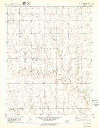
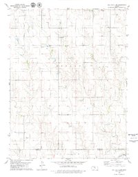
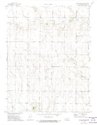 1972 Castle Rock NE1974 Print · USGSThe Trego County plains are captured here in the early 1970s, showcasing a landscape defined by deep creek drainages and rural life. Genealogists and historians can trace family-named landmarks like Banner Ch and the winding paths of Big Creek and Downer Creek.
 - 1974 Map of Castle Rock, 1976 Print
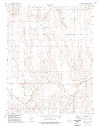 1974 Castle Rock1976 Print · USGSWestern Kansas in the mid-seventies is documented here through its high plains terrain and historical transit corridors. Researchers can trace the path of the Butterfield Overland Trail and locate landmarks like the Castle Rock formations and the Smoky Hill River.
 - 1974 Map of Cedar Bluff Dam, 1976 Print
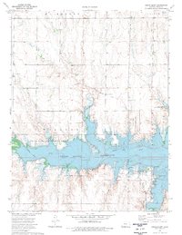
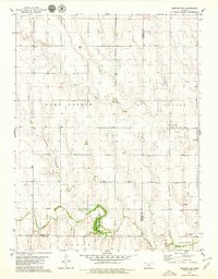
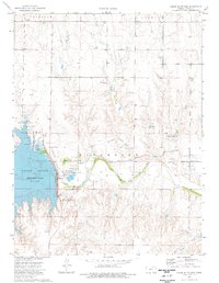 1974 Cedar Bluff Dam1976 Print · USGSThe Trego County plains are captured here in the mid-seventies, showing the impact of the Cedar Bluff Dam on the Smoky Hill River. Researchers can trace the Overland Trail or locate early energy sites like the Younger Oil Field.
 - 1974 Map of Gibson Creek, 1976 Print
 1974 Gibson Creek1976 Print · USGSWestern Kansas at the height of the 1970s reveals a landscape deeply connected to its pioneer past. You can trace the historic Butterfield (Approximate Overland Location) Trail and locate family-named landmarks like Gibson Creek and Hackberry Creek.
 - 1974 Map of Cedar Bluff, 1977 Print
 1974 Cedar Bluff1977 Print · USGSTrego County was defined by its water resources and pioneer routes during the mid-1970s. Trace the path of the historic Butterfield Trail near the Smoky Hill River and explore the development around the Cedar Bluff Reservoir.
 - 1974 Map of Ellis SE, 1977 Print
 1974 Ellis SE1977 Print · USGSWestern Kansas at the height of the 1970s oil boom reveals a landscape where historic wagon routes meet modern energy extraction. You can trace the Butterfield Trail across the plains or locate numerous oil sites like the Solburn Oil Field and West Ellis Oil Field.
 - 1974 Map of Fort Downer, 1977 Print
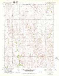
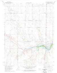 1974 Fort Downer1977 Print · USGSWestern Kansas in the mid-1970s reveals a landscape of frontier history and modern water management. Trace the Butterfield Overland Trail near the Ruins Fort Downer and the shoreline of the Cedar Bluff Reservoir.
 - 1979 Map of St Peter
 1979 St Peter1979 Print · USGSWestern Kansas at the close of the 1970s is defined by a landscape of grain and energy. Researchers can trace the rural infrastructure around St Peter, locating family landmarks like St Anthony Cem and the Leland Ch among active oil fields.
 - 1979 Map of Hay Hollow
 1979 Hay Hollow1979 Print · USGSThe Graham and Trego county line comes into focus in the late seventies, showing a High Plains landscape centered on petroleum production. Researchers can trace the extensive Oil Field development and local drainages like Hay Hollow and Happy Creek.
 - 1979 Map of Collyer
 1979 Collyer1979 Print · USGSWestern Kansas during the late seventies is characterized here by the rail-and-road corridor through Trego County. Trace the development of the Union Pacific line near Collyer and find smaller rail-side locations like Voda and Voda 2.2 unique versions available
 - 1979 Map of Hill City 4 NW
 1979 Hill City 4 NW1979 Print · USGSGraham County petroleum and prairie life intersect in the late 1970s across these High Plains townships. Genealogists and historians can trace local landmarks like Redline Ch, Township Cem, and the industry of the Cooper Oil Field.2 unique versions available
 - 1979 Map of Quinter NW
 1979 Quinter NW1979 Print · USGSThis late-seventies survey of Sheridan County explores the transition from agricultural townships to active energy production areas. Genealogists and researchers can trace the rural landscape through landmarks like Bethel Cem and the Sheridan State Game Management Area along the Saline River.
 - 1979 Map of Wild Horse Creek
 1979 Wild Horse Creek1979 Print · USGSIn the late 1970s, this Rooks County landscape was a hub of energy production and rail transport. Genealogists and historians can trace the community structures of Palco and find landmarks like Pleasantview Cem and the Marcotte Oil Field.2 unique versions available
 - 1979 Map of Quinter
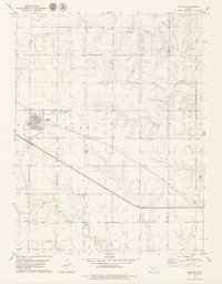 1979 Quinter1979 Print · USGSQuinter and the surrounding High Plains are captured in the late seventies at a crossroads of rail and road. Genealogists and local historians can trace the town grid and find significant sites like the Old Order Ch, Cem, and the Union Pacific line.
 - 1979 Map of Togo
 1979 Togo1979 Print · USGSThe Graham and Trego County borderlands are captured here during a busy era of late-century petroleum production. Local historians and genealogists can trace the rural community around Togo, the Prairie Home Ch, and the extensive Oil Field infrastructure.
End of results
Showing maps 1-16 of 16
Top cities of Trego County
Frequently asked questions
- What are the different types of historical maps available for Trego County?
- What is the oldest map of Trego County?
- Where can I purchase historical maps of Trego County for my home or office?
- Where can I download high-res historical maps of Trego County?
- Are there historical topographic maps available for Trego County?
- Is there historical aerial imagery available for Trego County?
- Where are historical maps of Trego County sourced from?