1960s Maps of Calcasieu Parish, Louisiana
Explore 5 historic maps of Calcasieu Parish from the 1960s. These maps offer a rare glimpse into what life looked like during the 1960s — showing old roads, neighborhoods, homes, and landmarks that have changed or disappeared over time.
Whether you're researching your family's past, planning a metal detecting trip, or studying how Calcasieu Parish's landscape evolved across the 1960s, these high-resolution maps are a powerful tool for exploring the history of this region.
- Focus on a specific era: All maps on this page are from the 1960s, giving you a focused view of this time period.
- See what’s changed: Compare century-old streets, trails, and buildings to today's modern landscape using overlays and satellite layers.
- Research with precision: Use these maps for genealogy, historical research, land use analysis, or educational projects.
- View, download, or print: Maps are fully viewable online in high resolution, and can be downloaded or printed for your own records.
Start exploring Calcasieu Parish's history through authentic maps from the 1960s. This is your window into the past.
Calcasieu Parish, LA maps
(5)- 1960 Map of Echo, 1961 Print
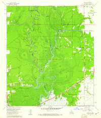 1960 Echo1961 Print · USGSThe Sabine River bottomlands on the Texas-Louisiana border are captured here at the start of the 1960s. Researchers can trace the winding river at Niblett Bluff and locate family landmarks like Comier Cem and Crossroad Ch.4 unique versions available
 - 1960 Map of Vinton, 1961 Print
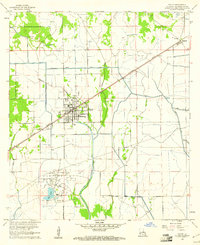 1960 Vinton1961 Print · USGSCalcasieu Parish in the early sixties reveals a landscape shaped by oil production and heavy irrigation. Genealogists and industrial historians can trace the derrick-lined Vinton Oil Field and old settlements like Ged, Edgerly, and Hampton.4 unique versions available
 - 1960 Map of Orange, 1961 Print
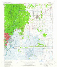
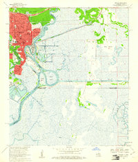 1960 Orange1961 Print · USGSOrange and the Sabine River borderlands at the start of the sixties reveal a thriving maritime and industrial hub. Genealogists and researchers can locate the U S Naval Station, historical schools like Stark High Sch, and Evergreen Cem.5 unique versions available
 - 1960 Map of Cameron Farms, 1961 Print
 1960 Cameron Farms1961 Print · USGSCoastal Louisiana marshes at the dawn of the 1960s reveal a landscape of oil extraction and maritime transit. Researchers can trace the development of the Gum Cove Oil and Gas Field and locate historic crossings like the Gum Cove Ferry.3 unique versions available
 - 1960 Map of Orange, 1961 Print
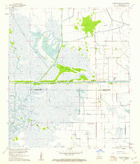
 1960 Orange1961 Print · USGSThe Texas-Louisiana borderlands come alive in the early sixties, showing the industrial waterfront of Orange alongside the rail-tied towns of Vinton and Edgerly. Genealogists and historians can locate rural landmarks like Granger Cem, Manley Sch, and the riverside Niblett Bluff.2 unique versions available
End of results
Showing maps 1-5 of 5
Top cities of Calcasieu Parish
- Lake Charles historical maps
- Sulphur historical maps
- Westlake historical maps
- Vinton historical maps
- DeQuincy historical maps
- Iowa historical maps
See more
Frequently asked questions
- What are the different types of historical maps available for Calcasieu Parish?
- What is the oldest map of Calcasieu Parish?
- Where can I purchase historical maps of Calcasieu Parish for my home or office?
- Where can I download high-res historical maps of Calcasieu Parish?
- Are there historical topographic maps available for Calcasieu Parish?
- Is there historical aerial imagery available for Calcasieu Parish?
- Where are historical maps of Calcasieu Parish sourced from?