1990s Maps of Calcasieu Parish, Louisiana
Explore 25 historic maps of Calcasieu Parish from the 1990s. These maps offer a rare glimpse into what life looked like during the 1990s — showing old roads, neighborhoods, homes, and landmarks that have changed or disappeared over time.
Whether you're researching your family's past, planning a metal detecting trip, or studying how Calcasieu Parish's landscape evolved across the 1990s, these high-resolution maps are a powerful tool for exploring the history of this region.
- Focus on a specific era: All maps on this page are from the 1990s, giving you a focused view of this time period.
- See what’s changed: Compare century-old streets, trails, and buildings to today's modern landscape using overlays and satellite layers.
- Research with precision: Use these maps for genealogy, historical research, land use analysis, or educational projects.
- View, download, or print: Maps are fully viewable online in high resolution, and can be downloaded or printed for your own records.
Start exploring Calcasieu Parish's history through authentic maps from the 1990s. This is your window into the past.
Calcasieu Parish, LA maps
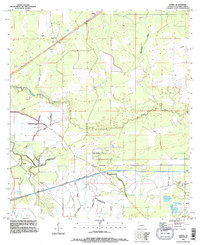
(25)- 1994 Map of Gordon, 1996 Print
 1994 Gordon1996 Print · USGSThe Beauregard and Calcasieu Parish border comes into focus in the mid-1990s, showing a landscape shaped by timber and oil. Genealogists can locate Gillie Cem and Alston Cem while tracing landmarks like the Lookout Tower and Boy Scout Camp.
 - 1994 Map of Echo, 1996 Print
 1994 Echo1996 Print · USGSThe Sabine River borderlands in the mid-nineties reveal a landscape of dense wetlands and river-edge settlements. Researchers can trace family history through sites like Cormier Cem and Lee Cem or explore named landmarks like Niblett Bluff and Echo.
 - 1994 Map of Starks, 1996 Print
 1994 Starks1996 Print · USGSThe Louisiana-Texas borderlands come to life in the mid-1990s, centered on the Sabine River and the community of Starks. Researchers can trace the river's winding oxbows around Sabine Island or locate family history at St Mary Cem and Doyle Cem.
 - 1994 Map of De Quincy, 1996 Print
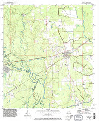
 1994 De Quincy1996 Print · USGSCalcasieu Parish in the mid-1990s was a landscape defined by the intersection of rail, timber, and the energy industry. Researchers can trace the layout of De Quincy and locate outlying communities like Hargrove or the resource-rich North De Quincy Oil Field.
 - 1994 Map of Iowa, 1996 Print
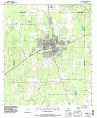
 1994 Iowa1996 Print · USGSCalcasieu Parish's industrial and agricultural character is on full display in the mid-1990s. Researchers can trace oil and gas history at Iowa Oil and Gas Field and explore old settlements like Chalkley and Holmwood.
 - 1994 Map of Vinton, 1996 Print
 1994 Vinton1996 Print · USGSCoastal Louisiana in the mid-nineties shows a landscape defined by petroleum and water management. Trace the industrial footprint of the Vinton Oil Field and the complex drainage networks of the Vinton Canal and Sabine Canal.
 - 1994 Map of Lunita, 1996 Print
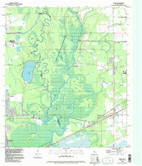
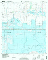
 1994 Lunita1996 Print · USGSCalcasieu Parish in the mid-nineties shows a landscape defined by significant water engineering and small rural settlements. Genealogists and local historians can locate Big Woods Cem and Benevolent Cem, or trace the massive SABINE RIVER DIVERSION SYSTEM and the course of the Houston River.
 - 1994 Map of Sulphur, 1996 Print
 1994 Sulphur1996 Print · USGSCalcasieu Parish comes into focus during the mid-nineties as the industrial and residential centers of Sulphur and Carlyss expand. Researchers can trace local landmarks like Roseland Cem, the historic site of Brimstone, and the regional Southland Field.
 - 1994 Map of Hecker, 1996 Print
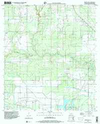
 1994 Hecker1996 Print · USGSCalcasieu and Jefferson Davis Parishes are shown in the mid-1990s, revealing a landscape defined by industrial oil fields and deep-rooted bayou settlements. Local researchers can trace family landmarks like Hebert Cem and La France Cem or explore the wetlands surrounding Hecker and the Iowa Oil and Gas Field.
 - 1994 Map of Gaytine, 1996 Print
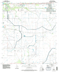
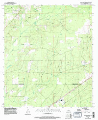
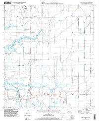
 1994 Gaytine1996 Print · USGSThe rural borders of Beauregard, Allen, and Calcasieu Parishes come together in the mid-1990s. Researchers can trace the local drainage along Indian Bayou and Marsh Bayou or locate small settlements like Gaytine and Turps.
 - 1994 Map of Lake Charles, 1996 Print
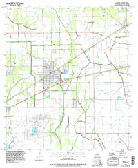
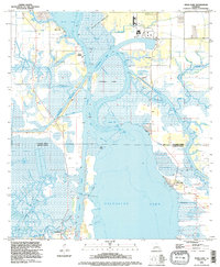
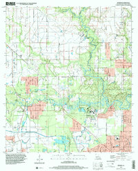
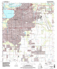 1994 Lake Charles1996 Print · USGSLake Charles and the surrounding Calcasieu Parish are shown here in the mid-1990s, caught between industrial growth and the surrounding coastal marsh. Genealogists and local historians can locate several burial grounds including Highland Cemetery, Bilbo Cem, and LeBleu Cem.
 - 1994 Map of Westlake, 1996 Print
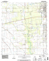
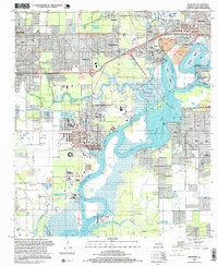
 1994 Westlake1996 Print · USGSThe industrial and maritime heart of Calcasieu Parish is revealed here during the mid-nineties, showing the intersection of heavy industry and residential growth. Genealogists and historians can locate family plots at Farquerar Cem and Burleson Cem or trace the early waterfront at Vincent Landing.
 - 1994 Map of Clark Hollow, 1996 Print
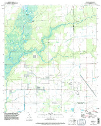
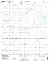
 1994 Clark Hollow1996 Print · USGSThe borderlands of Beauregard and Calcasieu Parishes are captured here in the mid-1990s, showing a landscape defined by timber, oil extraction, and deep watercourses. Researchers can locate family sites at Hyatt Cem or trace the drainage of Mule Pond and Sweet Gum Gully.
 - 1994 Map of Moss Bluff, 1996 Print
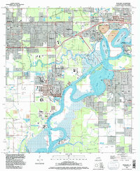
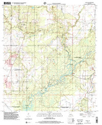
 1994 Moss Bluff1996 Print · USGSCoastal Louisiana north of Lake Charles comes into focus in the mid-nineties as Moss Bluff expands amidst a dense network of bayous and wetlands. Researchers can trace historic family burial sites like Rhodes Cem and West Fork Cem or explore the river-driven landscape around Bridge Junction.
 - 1994 Map of Moss Lake, 1996 Print
 1994 Moss Lake1996 Print · USGSCoastal Louisiana's industrial waterways dominate the landscape in the mid-1990s as the ship channels cut through the marshes. Researchers can trace family history at Dutch Cove Cem or explore the energy infrastructure of the Big Lake Oil Field.
 - 1996 Map of Westlake, 1999 Print
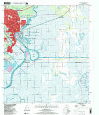
 1996 Westlake1999 Print · USGSThe Calcasieu River waterfront was a hub of petrochemical industry and maritime commerce in the mid-nineties. Genealogists and historians can trace family locations through Farquarer Cem or the settlements of Mossville and Vincent Landing.
 - 1996 Map of Starks, 1999 Print
 1996 Starks1999 Print · USGSThe Sabine River bottomlands come to life in the mid-nineties, showing the border country between Louisiana and Texas. Genealogists and local historians can locate St Mary Cem, trace the Kansas City Southern tracks through Starks, and explore the wetlands of Sabine Island.
 - 1996 Map of Orange, 1999 Print
 1996 Orange1999 Print · USGSNear the Texas-Louisiana border in the late nineties, the Sabine River supports a massive industrial and naval hub. Researchers can trace the development of Orange through its numerous schools like Solomon Johnson Sch and waterfront sites like Harbor Island.
 - 1998 Map of Sulphur, 2000 Print
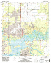
 1998 Sulphur2000 Print · USGSCalcasieu Parish at the close of the twentieth century shows a landscape defined by industry and water management. Researchers can trace the development of Sulphur and Carlyss, locating landmarks like Roseland Cem and the historic area of Brimstone.
 - 1998 Map of Black Lake, 2000 Print
 1998 Black Lake2000 Print · USGSThe marshlands of Calcasieu Parish meet the coastal waters of Cameron Parish in this late-twentieth-century study of Louisiana's energy landscape. Researchers can locate family landmarks like Moss Cem and Landry Cem amid the massive West Hackberry Oil Field.
 - 1998 Map of Brimstone, 2000 Print
 1998 Brimstone2000 Print · USGSThe industrial wetlands of Calcasieu Parish are documented here at the end of the millennium, showing a landscape defined by oil extraction. Researchers can trace the extensive pipelines and the operations at Edgerly Oil Field or locate the De Quincy Lookout Tower.
 - 1998 Map of Lake Charles SW, 2001 Print
 1998 Lake Charles SW2001 Print · USGSCoastal Louisiana at the close of the twentieth century shows a landscape defined by industry and water management across the Calcasieu-Cameron parish line. Trace local history at the Hebert Cem, Grand Lake Sch, and the Oil Field near the Intracoastal Waterway.
 - 1998 Map of Lake Charles SE, 2001 Print
 1998 Lake Charles SE2001 Print · USGSCalcasieu and Cameron Parishes are shown in the late 1990s, revealing a landscape of coastal prairie and managed waterways. Researchers can locate the community of Holmwood and local landmarks like St Joseph Ch and the Sweet Lake Pumping Station.
 - 1998 Map of Buhler, 2002 Print
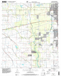
 1998 Buhler2002 Print · USGSCalcasieu Parish comes to life in this late twentieth-century survey, showcasing the river-bound communities north of Lake Charles. Researchers can trace rural landmarks like the Indian Bayou Ferry and the Willow Spring School alongside family sites like Lyle Cem.
 - 1998 Map of Topsy, 2002 Print
 1998 Topsy2002 Print · USGSThe Calcasieu River lowlands at the turn of the millennium reveal a complex web of bayous and cutoffs where three Louisiana parishes meet. Researchers can trace rural lineages at Creel Cem or Nevils Cem and locate landmarks like Camp Pearl and Topsy.
End of results
Showing maps 1-25 of 25
Top cities of Calcasieu Parish
- Lake Charles historical maps
- Sulphur historical maps
- Westlake historical maps
- Vinton historical maps
- DeQuincy historical maps
- Iowa historical maps
See more
Frequently asked questions
- What are the different types of historical maps available for Calcasieu Parish?
- What is the oldest map of Calcasieu Parish?
- Where can I purchase historical maps of Calcasieu Parish for my home or office?
- Where can I download high-res historical maps of Calcasieu Parish?
- Are there historical topographic maps available for Calcasieu Parish?
- Is there historical aerial imagery available for Calcasieu Parish?
- Where are historical maps of Calcasieu Parish sourced from?