1940s Maps of Calcasieu Parish, Louisiana
Explore 23 historic maps of Calcasieu Parish from the 1940s. These maps offer a rare glimpse into what life looked like during the 1940s — showing old roads, neighborhoods, homes, and landmarks that have changed or disappeared over time.
Whether you're researching your family's past, planning a metal detecting trip, or studying how Calcasieu Parish's landscape evolved across the 1940s, these high-resolution maps are a powerful tool for exploring the history of this region.
- Focus on a specific era: All maps on this page are from the 1940s, giving you a focused view of this time period.
- See what’s changed: Compare century-old streets, trails, and buildings to today's modern landscape using overlays and satellite layers.
- Research with precision: Use these maps for genealogy, historical research, land use analysis, or educational projects.
- View, download, or print: Maps are fully viewable online in high resolution, and can be downloaded or printed for your own records.
Start exploring Calcasieu Parish's history through authentic maps from the 1940s. This is your window into the past.
Calcasieu Parish, LA maps
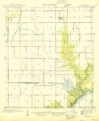
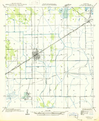
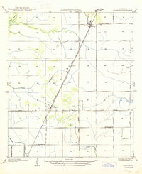
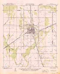
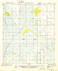
(23)- 1942 Map of Lake Charles
 1942 Lake Charles1942 Print · USGSLake Charles and the surrounding coastal prairies are captured here in the early 1940s, just as modern aviation and industrial shipping were reshaping the parish. Genealogists can locate family landmarks like Higgins School, Sweet Lake Church, and the neighborhood of Goosport.
 - 1946 Map of Moss Lake
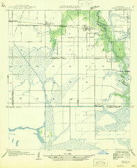
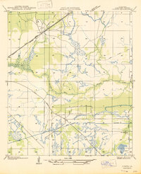
 1946 Moss Lake1946 Print · USGSThe coastal marshlands of southwest Louisiana come alive in the 1940s, showing a world of bayous and boat landings. Trace the early routes around Hackberry or locate historic sites like Ellender Ferry and Dutch Cove Cemetery along the river.
 - 1946 Map of Phoenix Lake
 1946 Phoenix Lake1946 Print · USGSThe Louisiana-Texas borderlands along the Sabine River are captured here in the mid-1940s, showing a transition from swampy wilderness to industrial waterway. Researchers can trace the development of the Intracoastal Waterway and locate named landmarks like Sassafras Island and Perry Ridge.
 - 1946 Map of Lacassine
 1946 Lacassine1946 Print · USGSSouthwestern Louisiana’s prairie and marshland are captured here in the mid-1940s as the rail and canal systems shaped local industry. Family historians can trace the area around Lacassine and Verrett, identifying landmarks like St Joseph Ch and Yount Lee Siding.
 - 1946 Map of Hayes
 1946 Hayes1946 Print · USGSCoastal prairie and marshlands meet along the Calcasieu-Jefferson Davis Parish line just after the war. Local researchers can trace the intricate network of the Morgan Canal, the Southern Pacific rail line, and the location of the Hayes Sch.
 - 1947 Map of Sulphur
 1947 Sulphur1947 Print · USGSIn Calcasieu Parish during the mid-1940s, the rail and road networks around Sulphur supported a growing industrial landscape. Genealogists and researchers can trace local landmarks like Choupique Sch and the vanished stop at Brimstone.
 - 1947 Map of Starks
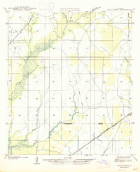
 1947 Starks1947 Print · USGSCoastal Louisiana meets the Texas border in the mid-1930s, where the winding Sabine River and extensive timber tracks define the land. Trace old family sites at Fountain Cem, the timber-era Old Logging Railroad Grade, and the ferry landing at Deweyville.
 - 1947 Map of Gaytine
 1947 Gaytine1947 Print · USGSLouisiana's bayou country is captured in the mid-1930s as the timber and rail era left its mark across Beauregard Parish. Researchers can trace the path of the Southern Pacific and the Old Logging Railroad Grade near Gaytine and Turps.
 - 1947 Map of Vinton
 1947 Vinton1947 Print · USGSCalcasieu Parish comes to life in the late 1940s, showing the intersection of rail-era commerce and early coastal drainage engineering. Genealogists and historians can trace the street grids of Vinton and find smaller locales like Ged or the railway siding at Edgerly.
 - 1947 Map of Toomey
 1947 Toomey1947 Print · USGSCalcasieu Parish at the Texas border is seen here in the late 1940s, where the winding river bottoms meet the railroad corridor. Researchers can trace family sites like Comier Cemetery and the settlement at Toomey along the Southern Pacific line.
 - 1947 Map of Fenton
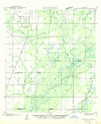
 1947 Fenton1947 Print · USGSMid-century Jefferson Davis Parish comes alive along the Missouri Pacific rail line and U.S. Highway 165 during this post-war period. Genealogists and local historians can trace the foundations of Fenton, find the Rose Hill School, and locate the Woodlawn Cem near the parish line.
 - 1947 Map of Moss Bluff
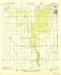
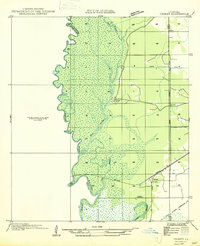
 1947 Moss Bluff1947 Print · USGSCalcasieu Parish's river-driven geography comes alive in this mid-century survey as the northern edge of Lake Charles begins to expand. Researchers can trace the era's vital river crossings at Goss Ferry and Perkins Ferry or locate the historic Ritchie Cem.
 - 1947 Map of Carter Creek
 1947 Carter Creek1947 Print · USGSThe Louisiana-Texas borderlands along the Sabine River are documented here in the mid-1940s, showing a landscape shaped by river bends and logging. Researchers can trace the Old Logging Railroad Grade and locate family landmarks like Duetts Ch and Clarks Cem.
 - 1947 Map of Hecker
 1947 Hecker1947 Print · USGSCalcasieu Parish was undergoing a significant transition between the world wars as timber harvesting and irrigation-based farming shaped the land. Researchers can trace the path of the Logging Railroad and locate family homes near Hecker and Stackpole.
 - 1947 Map of DeQuincy
 1947 DeQuincy1947 Print · USGSDe Quincy functioned as a vital rail crossroads in the late 1930s, situated at the meeting point of the Calcasieu and Beauregard parishes. Genealogists and historians can trace old homesteads near Rigmaiden Cem and the rail-side settlements at Sompayrac and Perkins.
 - 1947 Map of Sulphur Mines
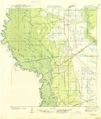
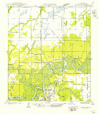
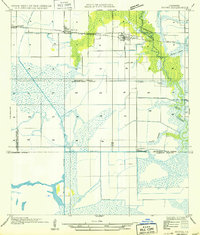
 1947 Sulphur Mines1947 Print · USGSCalcasieu Parish was a hub of resource extraction and water engineering in the years surrounding the Second World War. Researchers can trace the industrial footprint of the Edgerly Oil Field and the complex waterway network of the Union Sulphur Canal and Houston River.
 - 1947 Map of West Lake
 1947 West Lake1947 Print · USGSCalcasieu Parish was undergoing significant maritime expansion just after the war, centered on the vital ship canal and river system. Genealogists and historians can trace family roots at Farquhar Cemetery, find the old Vincent Sch, or locate the historic Vincent Landing.
 - 1947 Map of Thompson Bluff
 1947 Thompson Bluff1947 Print · USGSSouthwestern Louisiana's timber and river country is captured here during the late 1930s and 1940s. Researchers can trace the winding Calcasieu River and locate historic rural landmarks like Barnes Creek Ch and the Thompson Sch.
 - 1947 Map of Lunita
 1947 Lunita1947 Print · USGSCalcasieu Parish in the late 1930s shows an economy transitioning from timber to oil extraction. You can trace early industrial footprints like the Union Sulphur Canal (Abandoned), the Edgerly Oil Field, and the Big Woods Cem.
 - 1947 Map of Long Marsh
 1947 Long Marsh1947 Print · USGSLouisiana's timber and rail history is etched into the landscape at the Beauregard and Calcasieu parish line during the mid-1930s. Genealogists and historians can trace the Old Logging Railroad Grade and find family-named landmarks like Cowards Gully and Green Island.
 - 1949 Map of Cameron Farms
 1949 Cameron Farms1949 Print · USGSThe coastal marshlands of Calcasieu and Cameron Parishes are shown in the late 1940s during a period of significant water management. Researchers can trace the engineering of the Intracoastal Waterway and locate the rural settlement of Cameron Farms near Suttons Slip.
 - 1949 Map of Black Lake
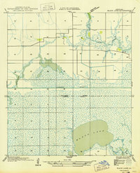 1949 Black Lake1949 Print · USGSCoastal wetlands and parish boundaries meet in the late 1940s as the Intracoastal Waterway transforms the marsh. Trace the natural shorelines of Black Lake and follow the winding path of Bayou Choupique across the prairie.
 - 1949 Map of Hayes
 1949 Hayes1949 Print · USGSCalcasieu and Jefferson Davis Parishes are shown during a period of agricultural expansion and marshland management in the late nineteen-forties. Researchers can trace the rail-and-water economy through features like the Southern Pacific line, the Hayes Sch, and the Illinois Plant.
End of results
Showing maps 1-23 of 23
Top cities of Calcasieu Parish
- Lake Charles historical maps
- Sulphur historical maps
- Westlake historical maps
- Vinton historical maps
- DeQuincy historical maps
- Iowa historical maps
See more
Frequently asked questions
- What are the different types of historical maps available for Calcasieu Parish?
- What is the oldest map of Calcasieu Parish?
- Where can I purchase historical maps of Calcasieu Parish for my home or office?
- Where can I download high-res historical maps of Calcasieu Parish?
- Are there historical topographic maps available for Calcasieu Parish?
- Is there historical aerial imagery available for Calcasieu Parish?
- Where are historical maps of Calcasieu Parish sourced from?