Old Maps of Calcasieu Parish, Louisiana for Metal Detecting
Plan your next treasure hunt with 255 historic maps of Calcasieu Parish. Find old homesites, ghost towns, trails, and gathering spots that may be lost to time — perfect for identifying promising metal detecting locations.
- Locate forgotten sites: Uncover places like long-lost settlements, abandoned rail lines, or gathering spots.
- Plan better hunts: Use map overlays combined with LiDAR or satellite views to narrow in on historically rich areas.
- Made for detectorists: Thousands of hobbyists use these maps to discover relics, coins, and hidden history.
Use these historic maps to boost your research and find new opportunities beneath the surface of Calcasieu Parish.
Calcasieu Parish, LA maps
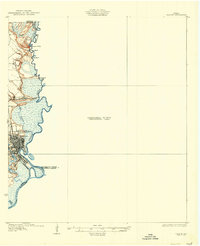
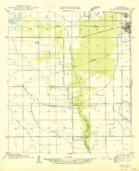
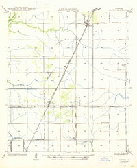
(255)- 1932 Map of Lake Charles NE
 1932 Lake Charles NE1932 Print · USGSCalcasieu Parish at the start of the 1930s shows an intricate landscape of prairie agriculture and vital rail connections. Genealogists and historians can trace old homesteads and community hubs like Chloe, Bon Air, and the Holmwood Sch.
 - 1932 Map of Moss Lake
 1932 Moss Lake1932 Print · USGSCoastal Calcasieu Parish comes to life in the early 1930s as the Intracoastal Waterway begins to reshape the landscape. Researchers can trace family roots at Hackberry or locate the historic Dutch Cove Cemetery and Ellender Ferry crossings.
 - 1932 Map of Lake Charles NW
 1932 Lake Charles NW1932 Print · USGSLake Charles and Calcasieu Parish are shown here in the early thirties as the region’s rail and water networks supported a growing coastal economy. Genealogists can locate family landmarks like La Grange High Sch, Davies, and the Lake Charles Landing Field.
 - 1932 Map of Orange
 1932 Orange1932 Print · USGSSoutheastern Texas at the dawn of the 1930s is defined by the bustling riverfront of Orange and the intricate bends of the Sabine River. Researchers can trace the early street plan of the city, the Southern Pacific rail lines, and river landmarks like Morgan Bluff.2 unique versions available
 - 1932 Map of Lake Charles SW
 1932 Lake Charles SW1932 Print · USGSIn the early 1930s, this portion of southern Louisiana was a landscape defined by the meeting of coastal wetlands and rural prairie. Genealogists and local historians can locate early educational and religious centers like Grand Lake Sch and Prairieland Community Ch near the banks of Black Bayou.
 - 1932 Map of Lake Charles SE
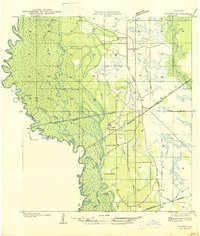
 1932 Lake Charles SE1932 Print · USGSCalcasieu and Cameron Parishes are captured here in the early thirties, showing a rural landscape shaped by rail and irrigation. Genealogists can locate the Sweet Lake Sch and the settlement of Holmwood along the Southern Pacific line.
 - 1935 Map of Buhler
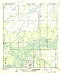
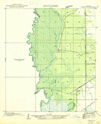
 1935 Buhler1935 Print · USGSCalcasieu Parish was undergoing a significant transition in the mid-1930s as logging infrastructure gave way to modern highways and canals. Genealogists and researchers can trace early river crossings like Anthony Ferry and the remnants of the Old Logging Railroad Grade near Buhler.
 - 1935 Map of Moss Bluff
 1935 Moss Bluff1935 Print · USGSCalcasieu Parish at the midpoint of the thirties reveals a river-driven landscape being reshaped by the Southern Pacific railroad. Genealogists and historians can locate family landmarks like Ritchie Cem, the old Moser Mill, and river crossings at Goss Ferry.
 - 1935 Map of Gordon
 1935 Gordon1935 Print · USGSLouisiana timber and rail history intersect at the small settlement of Gordon during the mid-1930s. Genealogists and researchers can trace early transport networks through the Old Logging Railroad, Pilgrims Rest Ch, and the Missouri Pacific line.
 - 1935 Map of Gaytine
 1935 Gaytine1935 Print · USGSSouthwestern Louisiana's wetlands and timber country are captured here in the mid-1930s as the logging era left its mark on the landscape. Researchers can trace old industrial footprints through the Old Logging Railroad Grade and find small communities like Gaytine and Turps.
 - 1942 Map of Lake Charles
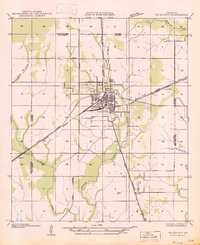
 1942 Lake Charles1942 Print · USGSLake Charles and the surrounding coastal prairies are captured here in the early 1940s, just as modern aviation and industrial shipping were reshaping the parish. Genealogists can locate family landmarks like Higgins School, Sweet Lake Church, and the neighborhood of Goosport.
 - 1946 Map of Moss Lake
 1946 Moss Lake1946 Print · USGSThe coastal marshlands of southwest Louisiana come alive in the 1940s, showing a world of bayous and boat landings. Trace the early routes around Hackberry or locate historic sites like Ellender Ferry and Dutch Cove Cemetery along the river.
 - 1946 Map of Phoenix Lake
 1946 Phoenix Lake1946 Print · USGSThe Louisiana-Texas borderlands along the Sabine River are captured here in the mid-1940s, showing a transition from swampy wilderness to industrial waterway. Researchers can trace the development of the Intracoastal Waterway and locate named landmarks like Sassafras Island and Perry Ridge.
 - 1946 Map of Lacassine
 1946 Lacassine1946 Print · USGSSouthwestern Louisiana’s prairie and marshland are captured here in the mid-1940s as the rail and canal systems shaped local industry. Family historians can trace the area around Lacassine and Verrett, identifying landmarks like St Joseph Ch and Yount Lee Siding.
 - 1946 Map of Hayes
 1946 Hayes1946 Print · USGSCoastal prairie and marshlands meet along the Calcasieu-Jefferson Davis Parish line just after the war. Local researchers can trace the intricate network of the Morgan Canal, the Southern Pacific rail line, and the location of the Hayes Sch.
 - 1947 Map of Sulphur
 1947 Sulphur1947 Print · USGSIn Calcasieu Parish during the mid-1940s, the rail and road networks around Sulphur supported a growing industrial landscape. Genealogists and researchers can trace local landmarks like Choupique Sch and the vanished stop at Brimstone.
 - 1947 Map of Starks
 1947 Starks1947 Print · USGSCoastal Louisiana meets the Texas border in the mid-1930s, where the winding Sabine River and extensive timber tracks define the land. Trace old family sites at Fountain Cem, the timber-era Old Logging Railroad Grade, and the ferry landing at Deweyville.
 - 1947 Map of Gaytine
 1947 Gaytine1947 Print · USGSLouisiana's bayou country is captured in the mid-1930s as the timber and rail era left its mark across Beauregard Parish. Researchers can trace the path of the Southern Pacific and the Old Logging Railroad Grade near Gaytine and Turps.
 - 1947 Map of Vinton
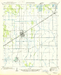 1947 Vinton1947 Print · USGSCalcasieu Parish comes to life in the late 1940s, showing the intersection of rail-era commerce and early coastal drainage engineering. Genealogists and historians can trace the street grids of Vinton and find smaller locales like Ged or the railway siding at Edgerly.
 - 1947 Map of Toomey
 1947 Toomey1947 Print · USGSCalcasieu Parish at the Texas border is seen here in the late 1940s, where the winding river bottoms meet the railroad corridor. Researchers can trace family sites like Comier Cemetery and the settlement at Toomey along the Southern Pacific line.
 - 1947 Map of Fenton
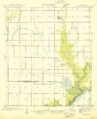
 1947 Fenton1947 Print · USGSMid-century Jefferson Davis Parish comes alive along the Missouri Pacific rail line and U.S. Highway 165 during this post-war period. Genealogists and local historians can trace the foundations of Fenton, find the Rose Hill School, and locate the Woodlawn Cem near the parish line.
 - 1947 Map of Moss Bluff
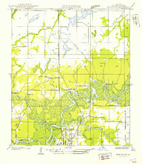 1947 Moss Bluff1947 Print · USGSCalcasieu Parish's river-driven geography comes alive in this mid-century survey as the northern edge of Lake Charles begins to expand. Researchers can trace the era's vital river crossings at Goss Ferry and Perkins Ferry or locate the historic Ritchie Cem.
 - 1947 Map of Carter Creek
 1947 Carter Creek1947 Print · USGSThe Louisiana-Texas borderlands along the Sabine River are documented here in the mid-1940s, showing a landscape shaped by river bends and logging. Researchers can trace the Old Logging Railroad Grade and locate family landmarks like Duetts Ch and Clarks Cem.
 - 1947 Map of Hecker
 1947 Hecker1947 Print · USGSCalcasieu Parish was undergoing a significant transition between the world wars as timber harvesting and irrigation-based farming shaped the land. Researchers can trace the path of the Logging Railroad and locate family homes near Hecker and Stackpole.
 - 1947 Map of DeQuincy
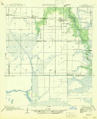
 1947 DeQuincy1947 Print · USGSDe Quincy functioned as a vital rail crossroads in the late 1930s, situated at the meeting point of the Calcasieu and Beauregard parishes. Genealogists and historians can trace old homesteads near Rigmaiden Cem and the rail-side settlements at Sompayrac and Perkins.
Showing maps 1-25 of 255
Top cities of Calcasieu Parish
- Lake Charles historical maps
- Sulphur historical maps
- Westlake historical maps
- Vinton historical maps
- DeQuincy historical maps
- Iowa historical maps
See more
Frequently asked questions
- What are the different types of historical maps available for Calcasieu Parish?
- What is the oldest map of Calcasieu Parish?
- Where can I purchase historical maps of Calcasieu Parish for my home or office?
- Where can I download high-res historical maps of Calcasieu Parish?
- Are there historical topographic maps available for Calcasieu Parish?
- Is there historical aerial imagery available for Calcasieu Parish?
- Where are historical maps of Calcasieu Parish sourced from?