1940s Maps of St. Landry Parish, Louisiana
Explore 6 historic maps of St. Landry Parish from the 1940s. These maps offer a rare glimpse into what life looked like during the 1940s — showing old roads, neighborhoods, homes, and landmarks that have changed or disappeared over time.
Whether you're researching your family's past, planning a metal detecting trip, or studying how St. Landry Parish's landscape evolved across the 1940s, these high-resolution maps are a powerful tool for exploring the history of this region.
- Focus on a specific era: All maps on this page are from the 1940s, giving you a focused view of this time period.
- See what’s changed: Compare century-old streets, trails, and buildings to today's modern landscape using overlays and satellite layers.
- Research with precision: Use these maps for genealogy, historical research, land use analysis, or educational projects.
- View, download, or print: Maps are fully viewable online in high resolution, and can be downloaded or printed for your own records.
Start exploring St. Landry Parish's history through authentic maps from the 1940s. This is your window into the past.
St. Landry Parish, LA maps
(6)- 1940 Map of Arnaudville, 1964 Print
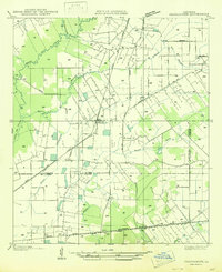
 1940 Arnaudville1964 Print · USGSThe Cajun heartland of the 1940s is detailed here as it manages its complex relationship with the Atchafalaya. Genealogists can trace family names through landmarks like Le Bourgeois Plantation, Magenta Plantation, and the St Elizabeth Ch & Sch.
 - 1947 Map of Redland
 1947 Redland1947 Print · USGSThe prairies of southern Louisiana come alive in this post-war map of the area around Eunice and the Bayou des Cannes. Researchers can trace old rail corridors like the Southern Pacific and locate rural landmarks such as Duralde Sch and Fenris.
 - 1947 Map of Chataignier
 1947 Chataignier1947 Print · USGSCoastal prairie life and Bayou country are captured here in the late Forties at the edge of the Evangeline and St. Landry Parish line. Genealogists can trace early homesteads and landmarks like St. Joseph Ch and Point Blue Sch along the Texas and Pacific rail line.
 - 1947 Map of Eunice
 1947 Eunice1947 Print · USGSThe rail-and-bayou landscape of south Louisiana comes alive in the mid-1940s, centered on the growing town of Eunice. Local researchers can trace family roots through rural landmarks like Bozyone Sch and the smaller settlements of Mowata and Amy.
 - 1947 Map of Pitreville
 1947 Pitreville1947 Print · USGSLouisiana's Acadia and St. Landry parishes are captured here in the mid-1940s, showing a rural landscape shaped by winding bayous and early highways. Genealogists and local historians can locate family landmarks like Courville Cem, Hundley Sch, and the Acadia Academy.
 - 1948 Map of Bunkie, 1950 Print
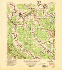 1948 Bunkie1950 Print · USGSThe Bunkie area during the late 1940s reveals a landscape defined by Bayou Boeuf and a dense network of early oil infrastructure. Genealogists can trace family roots through numerous rural landmarks like St Lukes Ch & Cem and the Goudeau Sch.
End of results
Showing maps 1-6 of 6
Top cities of St. Landry Parish
- Opelousas historical maps
- Eunice historical maps
- Sunset historical maps
- Port Barre historical maps
- Melville historical maps
- Krotz Springs historical maps
See more
Frequently asked questions
- What are the different types of historical maps available for St. Landry Parish?
- What is the oldest map of St. Landry Parish?
- Where can I purchase historical maps of St. Landry Parish for my home or office?
- Where can I download high-res historical maps of St. Landry Parish?
- Are there historical topographic maps available for St. Landry Parish?
- Is there historical aerial imagery available for St. Landry Parish?
- Where are historical maps of St. Landry Parish sourced from?