1970s Maps of St. Landry Parish, Louisiana
Explore 9 historic maps of St. Landry Parish from the 1970s. These maps offer a rare glimpse into what life looked like during the 1970s — showing old roads, neighborhoods, homes, and landmarks that have changed or disappeared over time.
Whether you're researching your family's past, planning a metal detecting trip, or studying how St. Landry Parish's landscape evolved across the 1970s, these high-resolution maps are a powerful tool for exploring the history of this region.
- Focus on a specific era: All maps on this page are from the 1970s, giving you a focused view of this time period.
- See what’s changed: Compare century-old streets, trails, and buildings to today's modern landscape using overlays and satellite layers.
- Research with precision: Use these maps for genealogy, historical research, land use analysis, or educational projects.
- View, download, or print: Maps are fully viewable online in high resolution, and can be downloaded or printed for your own records.
Start exploring St. Landry Parish's history through authentic maps from the 1970s. This is your window into the past.
St. Landry Parish, LA maps
(9)- 1970 Map of Carencro, 1972 Print
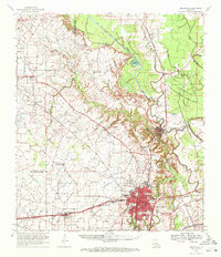
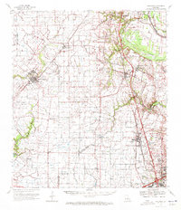 1970 Carencro1972 Print · USGSCajun country at the start of the seventies reveals a landscape where deep-rooted parish settlements like Grand Coteau exist alongside a booming energy industry. Trace family roots and local landmarks from Mt Pleasant Ch Cem to the Vatican Oil Field.
 - 1970 Map of Odenburg, 1972 Print
 1970 Odenburg1972 Print · USGSThe Atchafalaya Basin in the early seventies shows a landscape defined by massive flood control projects and traditional bayou settlements. Genealogists can locate family-named landmarks and rural congregations like Dunbar High Sch, St Matthew Ch, and Taterville.
 - 1970 Map of Fordoche, 1972 Print
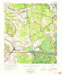
 1970 Fordoche1972 Print · USGSPointe Coupee Parish in the early seventies reveals a landscape defined by massive flood control projects and a growing oil economy. Genealogists and historians can trace family locations near Stonewall Plantation, the Valverda Sch, or the Indian Mound Valley Cem.
 - 1970 Map of Palmetto, 1972 Print
 1970 Palmetto1972 Print · USGSSt. Landry and Pointe Coupee Parishes are shown in the early seventies as a landscape of deep bayous and massive flood control works. Genealogists and historians can trace family locations near Rideau Settlement, Palmetto Cem, and Sacred Heart Ch.
 - 1970 Map of Portage, 1972 Print
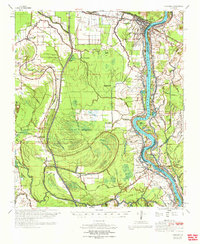
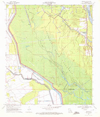 1970 Portage1972 Print · USGSThe Atchafalaya bottomlands near the St. Landry and St. Martin parish line are captured here in the early 1970s. Researchers can trace the hydraulic engineering of the era through the Levee system, the Krotz Springs Oil and Gas Field, and the settlement at Portage.2 unique versions available
 - 1970 Map of Arnaudville, 1972 Print
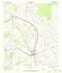
 1970 Arnaudville1972 Print · USGSThe heart of Acadiana is captured here in the early seventies as Cajun communities grew along the winding Bayou Teche. Genealogists and historians can trace family roots through sites like Ridge Zion Cem, Leonville Sch, and the Missouri Pacific Railroad corridor.2 unique versions available
 - 1970 Map of Opelousas, 1972 Print
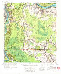
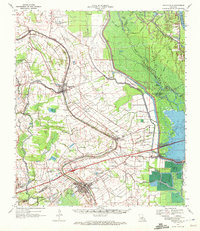
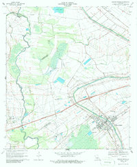
 1970 Opelousas1972 Print · USGSSt. Landry Parish in the early 1970s reveals a landscape defined by its bayous and a significant rail-to-river economy centered on Opelousas. Genealogists can trace family landmarks like Sacred Heart Chapel & Cem and Bertrand Cem across this detailed 1970 survey.2 unique versions available
 - 1970 Map of Arnaudville, 1972 Print
 1970 Arnaudville1972 Print · USGSThe Acadiana bayou country comes alive in the early seventies, centered on the junction of the Bayou Teche and Bayou Fusilier. Researchers can trace old family land patterns near Arnaudville and locate rural landmarks like Ring Zion Cemetery and Sacred Heart Chapel.2 unique versions available
 - 1970 Map of Breaux Bridge, 1972 Print
 1970 Breaux Bridge1972 Print · USGSBreaux Bridge and the surrounding Cajun heartland are shown here in the early seventies, where water and industry shape the landscape. Genealogists and historians can trace family sites from Anse La Butte to Bushville or locate Strauss Cem and the Anse La Butte Oil and Gas Field.3 unique versions available
End of results
Showing maps 1-9 of 9
Top cities of St. Landry Parish
- Opelousas historical maps
- Eunice historical maps
- Sunset historical maps
- Port Barre historical maps
- Melville historical maps
- Krotz Springs historical maps
See more
Frequently asked questions
- What are the different types of historical maps available for St. Landry Parish?
- What is the oldest map of St. Landry Parish?
- Where can I purchase historical maps of St. Landry Parish for my home or office?
- Where can I download high-res historical maps of St. Landry Parish?
- Are there historical topographic maps available for St. Landry Parish?
- Is there historical aerial imagery available for St. Landry Parish?
- Where are historical maps of St. Landry Parish sourced from?