1960s Maps of St. Landry Parish, Louisiana
Explore 16 historic maps of St. Landry Parish from the 1960s. These maps offer a rare glimpse into what life looked like during the 1960s — showing old roads, neighborhoods, homes, and landmarks that have changed or disappeared over time.
Whether you're researching your family's past, planning a metal detecting trip, or studying how St. Landry Parish's landscape evolved across the 1960s, these high-resolution maps are a powerful tool for exploring the history of this region.
- Focus on a specific era: All maps on this page are from the 1960s, giving you a focused view of this time period.
- See what’s changed: Compare century-old streets, trails, and buildings to today's modern landscape using overlays and satellite layers.
- Research with precision: Use these maps for genealogy, historical research, land use analysis, or educational projects.
- View, download, or print: Maps are fully viewable online in high resolution, and can be downloaded or printed for your own records.
Start exploring St. Landry Parish's history through authentic maps from the 1960s. This is your window into the past.
St. Landry Parish, LA maps
(16)- 1960 Map of Ville Platte, 1961 Print
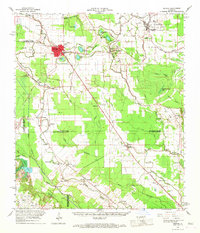
 1960 Ville Platte1961 Print · USGSEvangeline Parish at the start of the sixties shows a landscape of prairie rice farms, oil fields, and traditional Acadian settlements. Researchers can locate many family cemeteries and community landmarks like St Ann's Cem, Savoy Hosp, and the Mamou Oil Field.3 unique versions available
 - 1961 Map of Baton Rouge, 1966 Print
 1961 Baton Rouge1966 Print · USGSSoutheastern Louisiana in the early sixties remains a landscape of deep river bends and sprawling coastal lakes. Genealogists and historians can trace the rail-and-river economy through landmarks like Free-Nigger Point, Donaldsonville, and the Illinois Central Railroad.
 - 1962 Map of Baton Rouge
 1962 Baton Rouge1962 Print · USGSSouth Louisiana in the early sixties reveals a landscape of river-bend parishes and emerging interstate corridors. Genealogists and historians can trace family roots through historic river towns like Donaldsonville and Plaquemine, or follow the path of the Illinois Central Railroad through the swamp basins.
 - 1963 Map of Arnaudville, 1966 Print
 1963 Arnaudville1966 Print · USGSThe Acadiana region comes alive in this mid-century survey of the Bayou Teche country and the Atchafalaya Basin. Local historians can trace family-named sites like La Bourgeois Plantation and Nina Station, alongside old gathering places such as Ring Zion Ch. & Cem.2 unique versions available
 - 1965 Map of Morrow, 1967 Print
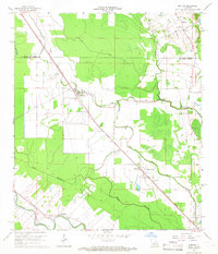 1965 Morrow1967 Print · USGSThe borderlands of St. Landry and Avoyelles Parishes were a grid of rail-side settlements and bayou-side farms in the mid-sixties. Local history researchers can trace the old rail corridors of the Texas and Pacific and locate rural landmarks like Lincoln Sch and Morrow Cem.2 unique versions available
 - 1966 Map of Whiteville, 1967 Print
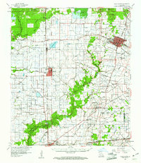
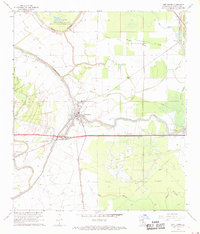
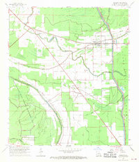
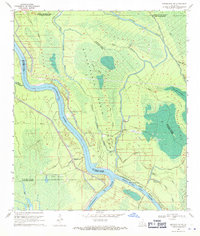
 1966 Whiteville1967 Print · USGSSt. Landry Parish in the mid-1960s was a landscape defined by Bayou waterways and the crossing of two major railroads. Researchers can trace the rail-and-river economy through sites like the Ville Platte Oil and Gas Field and communities like Gold Dust or St Louis.3 unique versions available
 - 1966 Map of Bunkie, 1967 Print
 1966 Bunkie1967 Print · USGSBunkie and the surrounding bayou country are captured in the mid-1960s as the regional rail and oil economies flourished. Genealogists can locate family landmarks like Lincoln Sch, Snowden Cem, and the Morning Star Ch Cem near Evergreen.
 - 1968 Map of Krotz Springs, 1969 Print
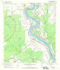
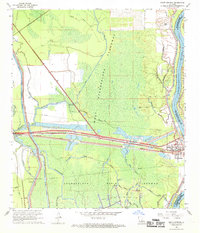 1968 Krotz Springs1969 Print · USGSSt. Landry Parish was a landscape of intensive water management and energy extraction in the late sixties. Trace the industrial footprint of the Krotz Springs Oil and Gas Field or locate burials at Midway Cem near the riverbanks.3 unique versions available
 - 1968 Map of Port Barre, 1969 Print
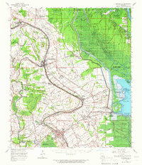
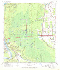
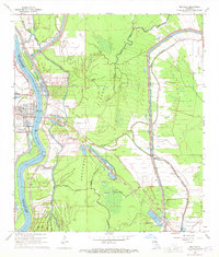
 1968 Port Barre1969 Print · USGSPort Barre and the surrounding St. Landry Parish lowlands are captured here in the late sixties at the junction of Bayou Teche and Bayou Courtableau. Researchers can trace family sites like Saquette Cemetery and St. Mary Church alongside the industrial footprint of the Port Barre Oil and Gas Field.2 unique versions available
 - 1968 Map of Lottie, 1969 Print
 1968 Lottie1969 Print · USGSPointe Coupee Parish is shown here in the late sixties as the industrial landscape of the Atchafalaya Basin matured. Local historians can trace the energy and rail network through the Lottie Oil and Gas Field and the Missouri Pacific line near Lottie.2 unique versions available
 - 1968 Map of Palmetto, 1970 Print
 1968 Palmetto1970 Print · USGSSt. Landry Parish in the late sixties shows a landscape of bayous and rail-side towns at the edge of the Atchafalaya basin. Genealogists and local historians can trace family locations near Rideau Settlement, the Palmetto Sch, and Immaculate Conception Sch.3 unique versions available
 - 1968 Map of Melville, 1970 Print
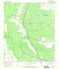
 1968 Melville1970 Print · USGSThe Atchafalaya basin in the late sixties reveals a landscape of levee-protected river towns and expanding energy infrastructure. Genealogists and historians can locate Melville, find rural churches like Zion Traveler Ch, and trace the Ravenswood Oil Field.2 unique versions available
 - 1968 Map of Swayze Lake, 1970 Print
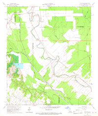
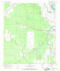 1968 Swayze Lake1970 Print · USGSSt. Landry Parish in the late 1960s is defined by the massive flood control infrastructure of the West Atchafalaya Floodway. Genealogists and local historians can trace the Texas and Pacific rail line through Sambo or locate the United Pentecostal Ch and nearby Cem.2 unique versions available
 - 1969 Map of Bayou Jack, 1971 Print
 1969 Bayou Jack1971 Print · USGSThe Atchafalaya Basin transition in the late 1960s reveals a landscape defined by flood control and rural bayou settlements. Genealogists and researchers can trace family landmarks like Mt Olive Ch Cem and Cason Cem near the banks of Bayou Rouge.3 unique versions available
 - 1969 Map of Maringouin NW, 1971 Print
 1969 Maringouin NW1971 Print · USGSThe Atchafalaya Basin in the late sixties shows a landscape defined by industrial extraction and flood control. Researchers can trace the footprints of the Happytown Oil and Gas Field and the complex waterways of Alabama Bayou and Lake Valerie.3 unique versions available
 - 1969 Map of Bayou Current, 1971 Print
 1969 Bayou Current1971 Print · USGSThe Atchafalaya River basin in the late sixties reveals a landscape of riverfront settlements and vast flood control works. Researchers can trace the river's human history through the Old Railroad Grade, an ancient Indian Mound, and numerous rural sites like Mason Chapel Cem.2 unique versions available
End of results
Showing maps 1-16 of 16
Top cities of St. Landry Parish
- Opelousas historical maps
- Eunice historical maps
- Sunset historical maps
- Port Barre historical maps
- Melville historical maps
- Krotz Springs historical maps
See more
Frequently asked questions
- What are the different types of historical maps available for St. Landry Parish?
- What is the oldest map of St. Landry Parish?
- Where can I purchase historical maps of St. Landry Parish for my home or office?
- Where can I download high-res historical maps of St. Landry Parish?
- Are there historical topographic maps available for St. Landry Parish?
- Is there historical aerial imagery available for St. Landry Parish?
- Where are historical maps of St. Landry Parish sourced from?