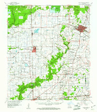
1960 Map of Ville Platte
USGS Topo · Published 1961About this map
Ville Platte serves as the focal point of this South Louisiana landscape, surveyed just as the region's agricultural traditions met the expanding petroleum industry. The map reveals a dense network of rice irrigation flumes and bayous, including Bayou des Cannes and Bayou Mallet, which crisscross the prairie between established settlements like Mamou and Chataignier. The Mamou Oil Field and various oil and gas operations signify the mid-century energy boom that transformed Evangeline Parish.
Find a feature on this map
75 named features on this map. Tap any name to fly to it.
Don’t see what you’re looking for? This feature index may not catch every label — zoom into the map to look around manually.
Map Details
Editions of this 1960 Ville Platte Map
3 editions found
Other maps of this area

1935 · Beaver
USGS Topo · 1:31,680

1935 · Turkey Creek
USGS Topo · 1:62,500

1939 · Opelousas
USGS Topo · 1:62,500

1942 · Oakdale
USGS Topo · 1:62,500

1947 · Ville Platte
USGS Topo · 1:31,680

1947 · Fruge Lake
USGS Topo · 1:31,680

1947 · Redland
USGS Topo · 1:31,680

1947 · Chataignier
USGS Topo · 1:31,680

1947 · Bond
USGS Topo · 1:31,680

1947 · Eunice
USGS Topo · 1:31,680