1960s Maps of Tangipahoa Parish, Louisiana
Explore 15 historic maps of Tangipahoa Parish from the 1960s. These maps offer a rare glimpse into what life looked like during the 1960s — showing old roads, neighborhoods, homes, and landmarks that have changed or disappeared over time.
Whether you're researching your family's past, planning a metal detecting trip, or studying how Tangipahoa Parish's landscape evolved across the 1960s, these high-resolution maps are a powerful tool for exploring the history of this region.
- Focus on a specific era: All maps on this page are from the 1960s, giving you a focused view of this time period.
- See what’s changed: Compare century-old streets, trails, and buildings to today's modern landscape using overlays and satellite layers.
- Research with precision: Use these maps for genealogy, historical research, land use analysis, or educational projects.
- View, download, or print: Maps are fully viewable online in high resolution, and can be downloaded or printed for your own records.
Start exploring Tangipahoa Parish's history through authentic maps from the 1960s. This is your window into the past.
Tangipahoa Parish, LA maps
(15)- 1961 Map of Baton Rouge, 1966 Print
 1961 Baton Rouge1966 Print · USGSSoutheastern Louisiana in the early sixties remains a landscape of deep river bends and sprawling coastal lakes. Genealogists and historians can trace the rail-and-river economy through landmarks like Free-Nigger Point, Donaldsonville, and the Illinois Central Railroad.
 - 1962 Map of Baton Rouge
 1962 Baton Rouge1962 Print · USGSSouth Louisiana in the early sixties reveals a landscape of river-bend parishes and emerging interstate corridors. Genealogists and historians can trace family roots through historic river towns like Donaldsonville and Plaquemine, or follow the path of the Illinois Central Railroad through the swamp basins.
 - 1963 Map of Killian, 1964 Print
 1963 Killian1964 Print · USGSLivingston Parish at the edge of the wetlands in the early sixties reveals a community closely tied to its rivers and bayous. Researchers can trace family sites like McKinney Cem and Davidson Cem or locate old landings such as Carthage Bluff Landing.4 unique versions available
 - 1963 Map of Springfield, 1964 Print
 1963 Springfield1964 Print · USGSLouisiana's river country comes to life in this early 1960s survey of the parish borderlands near the Natalbany River. Local historians can locate numerous rural landmarks like Warsaw Landing, Hungarian Ch, and the Albany-Springfield High Sch.4 unique versions available
 - 1963 Map of Springfield, 1967 Print
 1963 Springfield1967 Print · USGSThe Louisiana bayou country north of Lake Maurepas comes alive in the mid-1960s, showing a landscape of river landings and parish crossroads. Genealogists can trace family roots through sites like Redding Cem, Jefferson Cem, and the rural James Chapel.2 unique versions available
 - 1965 Map of Springfield
 1965 Springfield1965 Print · USGSLivingston Parish in the mid-1960s reveals a complex network of river landings and lowland settlements as they existed before modern expansion. Genealogists and historians can locate the Hungarian Settlement, numerous country churches like Holly Ch, and family cemeteries including McLin Cem and Carters Cem.
 - 1967 Map of Spanish Fort, 1969 Print
 1967 Spanish Fort1969 Print · USGSThe Jefferson and Orleans Parish lakefronts are shown here in the late sixties as suburban expansion reached the shores of Lake Pontchartrain. Trace the development of neighborhoods like Bucktown and Indian Beach alongside the New Orleans Lakefront Airport.
 - 1968 Map of Covington SW, 1969 Print
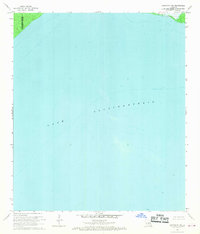 1968 Covington SW1969 Print · USGSCoastal Louisiana in the late sixties is defined by the sweeping waters of Lake Pontchartrain along the parish lines. Researchers can trace the submerged topography and key maritime markers like the scattered Light aids used for navigation.2 unique versions available
 - 1968 Map of Madisonville, 1969 Print
 1968 Madisonville1969 Print · USGSThe Tchefuncta River basin in the late sixties shows a transition from traditional river life to modern parish growth. Genealogists and local researchers can locate numerous historical burial sites and landmarks like Rosenwald Sch Cem, Penns Chapel, and Goodbee.4 unique versions available
 - 1968 Map of Manchac, 1969 Print
 1968 Manchac1969 Print · USGSThe Louisiana marshlands come alive in the late sixties as the rail-and-river network connects the shores of Lake Maurepas. Genealogists and historians can trace the small rail outposts of Manchac (Akers PO), Strader, and Galva along the Illinois Central corridor.2 unique versions available
 - 1968 Map of Ponchatoula, 1969 Print
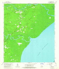
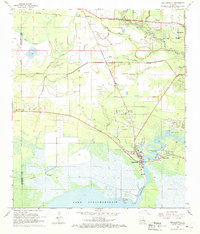
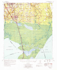
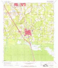 1968 Ponchatoula1969 Print · USGSTangipahoa Parish at the end of the sixties shows the steady growth of Ponchatoula and Hammond alongside the vital Illinois Central corridor. Genealogists can locate family landmarks such as Wetmore Cem, Mitchell Cem, and the French Corner Ch.3 unique versions available
 - 1968 Map of Ponchatoula NE, 1969 Print
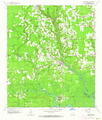
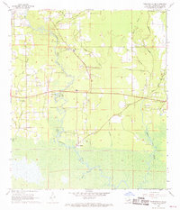 1968 Ponchatoula NE1969 Print · USGSTangipahoa Parish river life and rural settlements are captured here in the late sixties as the wilderness meets developing industry. Genealogists can trace family roots through numerous sites like Champ Cooper Sch, Lees Landing, and the Robertson Cem.4 unique versions available
 - 1968 Map of Ponchatoula SE, 1969 Print
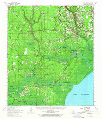
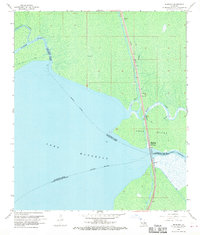
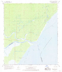 1968 Ponchatoula SE1969 Print · USGSIn the late sixties, the Tangipahoa parish shoreline remained a dense labyrinth of marshland and maritime passages. Trace the historic Indian Mounds on Jones Island or follow the shipping routes through Pass Manchac and North Pass.3 unique versions available
 - 1969 Map of Ponchatoula, 1971 Print
 1969 Ponchatoula1971 Print · USGSThe Florida Parishes meet the marshlands of the Lake Pontchartrain basin in the late sixties. Genealogists and historians can trace family-named sites like Arnold Cem, Lees Landing, and the Champ Cooper Sch near the ILLINOIS CENTRAL line.
 - 1969 Map of Covington, 1971 Print
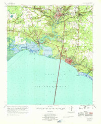 1969 Covington1971 Print · USGSSt. Tammany Parish's north shore of Lake Pontchartrain is shown in detail during the late sixties. Trace the development of Covington and Mandeville, or locate family sites like Daussin Cem and White Chapel.
End of results
Showing maps 1-15 of 15
Top cities of Tangipahoa Parish
- Hammond historical maps
- Ponchatoula historical maps
- Kentwood historical maps
- Independence historical maps
- Roseland historical maps
- Tangipahoa historical maps
See more
Frequently asked questions
- What are the different types of historical maps available for Tangipahoa Parish?
- What is the oldest map of Tangipahoa Parish?
- Where can I purchase historical maps of Tangipahoa Parish for my home or office?
- Where can I download high-res historical maps of Tangipahoa Parish?
- Are there historical topographic maps available for Tangipahoa Parish?
- Is there historical aerial imagery available for Tangipahoa Parish?
- Where are historical maps of Tangipahoa Parish sourced from?