1990s Maps of Tangipahoa Parish, Louisiana
Explore 6 historic maps of Tangipahoa Parish from the 1990s. These maps offer a rare glimpse into what life looked like during the 1990s — showing old roads, neighborhoods, homes, and landmarks that have changed or disappeared over time.
Whether you're researching your family's past, planning a metal detecting trip, or studying how Tangipahoa Parish's landscape evolved across the 1990s, these high-resolution maps are a powerful tool for exploring the history of this region.
- Focus on a specific era: All maps on this page are from the 1990s, giving you a focused view of this time period.
- See what’s changed: Compare century-old streets, trails, and buildings to today's modern landscape using overlays and satellite layers.
- Research with precision: Use these maps for genealogy, historical research, land use analysis, or educational projects.
- View, download, or print: Maps are fully viewable online in high resolution, and can be downloaded or printed for your own records.
Start exploring Tangipahoa Parish's history through authentic maps from the 1990s. This is your window into the past.
Tangipahoa Parish, LA maps
(6)- 1994 Map of McComb
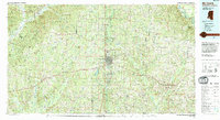 1994 McComb1994 Print · USGSSouthern Mississippi's rail-and-timber country is documented here in the early nineties as the region balanced its industrial corridors with vast forest preserves. Genealogists can trace hundreds of family-named rural landmarks, from Holmesville and Chatawa to the historic Zion Hill Ch.
 - 1994 Map of Springfield, 1996 Print
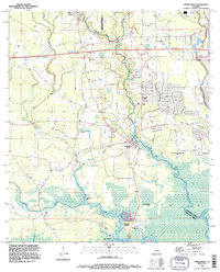 1994 Springfield1996 Print · USGSLivingston and Tangipahoa Parishes are shown in the mid-1990s as modern highway infrastructure met the ancient wetlands of the Tickfaw basin. Genealogists can locate family sites at Galilee Cem or Carters Cem and trace the old river settlements at Springfield and Warsaw Landing.
 - 1994 Map of Hammond, 1996 Print
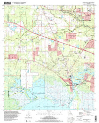
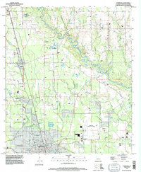 1994 Hammond1996 Print · USGSTangipahoa Parish in the mid-1990s shows a landscape of growing towns and deep-rooted family history. Researchers can trace the layout of Southeastern Louisiana University and locate numerous small burial grounds like Colonial Cem and Narretto Cem.
 - 1994 Map of Ponchatoula, 1996 Print
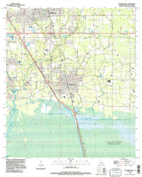 1994 Ponchatoula1996 Print · USGSThe Strawberry Capital of the World and the surrounding Tangipahoa Parish wetlands are captured here in the mid-nineties. Trace family roots at Arnold Cem or Mitchell Cem, and explore the reach of the Joyce State Wildlife Management Area.
 - 1998 Map of Madisonville, 2001 Print
 1998 Madisonville2001 Print · USGSThe lower Tchefuncta River and the shores of Lake Pontchartrain define this late-century landscape. Genealogists and historians can trace family roots at Helping Hands Cem, find the site of the Rosenwald Sch, or follow the Old Railroad Grade.
 - 1998 Map of Ponchatoula NE, 2001 Print
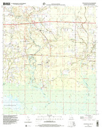 1998 Ponchatoula NE2001 Print · USGSTangipahoa Parish in the late 1990s showcases a landscape of river landings and remote wetlands before modern expansion. Genealogists can locate specific family burial sites at Sand Hill Cem and Edwards Cem or trace rural landmarks like Lees Landing.
End of results
Showing maps 1-6 of 6
Top cities of Tangipahoa Parish
- Hammond historical maps
- Ponchatoula historical maps
- Kentwood historical maps
- Independence historical maps
- Roseland historical maps
- Tangipahoa historical maps
See more
Frequently asked questions
- What are the different types of historical maps available for Tangipahoa Parish?
- What is the oldest map of Tangipahoa Parish?
- Where can I purchase historical maps of Tangipahoa Parish for my home or office?
- Where can I download high-res historical maps of Tangipahoa Parish?
- Are there historical topographic maps available for Tangipahoa Parish?
- Is there historical aerial imagery available for Tangipahoa Parish?
- Where are historical maps of Tangipahoa Parish sourced from?